Süderdorf
| coat of arms | Germany map | |
|---|---|---|

|
Coordinates: 54 ° 12 ' N , 9 ° 21' E |
|
| Basic data | ||
| State : | Schleswig-Holstein | |
| Circle : | Dithmarschen | |
| Office : | Parish land parishes of Eider | |
| Height : | 25 m above sea level NHN | |
| Area : | 16.21 km 2 | |
| Residents: | 345 (Dec. 31, 2019) | |
| Population density : | 21 inhabitants per km 2 | |
| Postal code : | 25782 | |
| Primaries : | 04802, 04838 | |
| License plate : | HEI, MED | |
| Community key : | 01 0 51 139 | |
| Office administration address: | Kirchspielsschreiber-Schmidt-Straße 1 25779 Hennstedt |
|
| Website : | ||
| Mayor : | Heino Grimm (WGS) | |
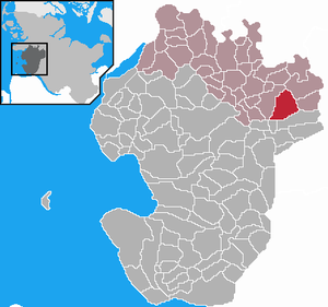
| Location of the community of Süderdorf in the district of Dithmarschen | ||
Süderdorf is a municipality in the Dithmarschen district in Schleswig-Holstein .
geography
The community is on the federal highway 203 about halfway between Heide and Rendsburg .
Community structure
The place is an area municipality on the Dithmarscher Geest , which is predominantly agricultural. It consists of the districts of Lendern, Lüdersbüttel, Schelrade and Wellerhop. A real town center does not exist.
history
On January 1, 1974, the previously independent municipalities of Lendern, Lüdersbüttel, Schelrade and Wellerhop were merged to form the new municipality of Süderdorf. They all emerged on April 1, 1934 from the disbanded parish Tellingstedt.
politics
Community representation
Since the local elections in 2013, the WGS community of voters has all nine seats in the municipal council.
coat of arms
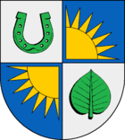
Blazon : “Quartered. 1 in silver a green horseshoe with upturned studs, 2 and 3 in blue a floating golden sun cut at the crossing, 4 in silver a green leaf. "
Sports
The game and sports club Süderdorf is very active in the village . Its membership reaches almost three quarters of the community's residents. Fistball, badminton, volleyball, cycling, running, bowling, sports badges and card games are offered.
Web links
- Municipality of Süderdorf at the parish regional authorities of Eider
Individual evidence
- ↑ North Statistics Office - Population of the municipalities in Schleswig-Holstein 4th quarter 2019 (XLSX file) (update based on the 2011 census) ( help on this ).
- ↑ Schleswig-Holstein topography. Vol. 9: Schönberg - Tielenhemme . 1st edition Flying-Kiwi-Verl. Junge, Flensburg 2007, ISBN 978-3-926055-91-0 , p. 276 ( dnb.de [accessed on August 6, 2020]).
- ^ Federal Statistical Office (ed.): Historical municipality directory for the Federal Republic of Germany. Name, border and key number changes in municipalities, counties and administrative districts from May 27, 1970 to December 31, 1982 . W. Kohlhammer, Stuttgart / Mainz 1983, ISBN 3-17-003263-1 , p. 181 .
- ↑ State Statistical Office Schleswig-Holstein (Ed.): The population of the communities in Schleswig-Holstein 1867-1970 . State Statistical Office Schleswig-Holstein, Kiel 1972, p. 251 .
- ↑ Final result of the local elections 2013 ( page no longer available , search in web archives ) Info: The link was automatically marked as defective. Please check the link according to the instructions and then remove this notice.
- ↑ Schleswig-Holstein's municipal coat of arms


