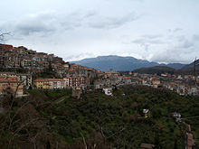
Segni (Lazio)
| Segni | ||
|---|---|---|

|
|
|
| Country | Italy | |
| region | Lazio | |
| Metropolitan city | Rome (RM) | |
| Coordinates | 41 ° 41 ' N , 13 ° 1' E | |
| height | 668 m slm | |
| surface | 61 km² | |
| Residents | 9,192 (Dec. 31, 2019) | |
| Population density | 151 inhabitants / km² | |
| Post Code | 00037 | |
| prefix | 06 | |
| ISTAT number | 058102 | |
| Popular name | Segnini | |
| Patron saint | San Bruno | |
| Website | Segni | |
Segni (Latin Signia) is an Italian commune with 9192 inhabitants (as of December 31, 2019) in the metropolitan city of Rome in the Lazio region .
geography
Segni is 58 km southeast of Rome and 40 km northwest of Frosinone . It is on the edge of the Monti Lepini on a ridge above the Sacco valley . The municipality extends from 187 to 1,378 m slm, on Monte Lupone. The districts Pantano, Pietrafalla, Recchia and Torre Santi, which lie in the valley, belong to the municipality.
Segni is a member of the Comunità Montana Monti Lepini . The community is located in earthquake zone 2 (medium risk).
The neighboring municipalities are Artena , Colleferro , Cori ( LT ), Gavignano , Montelanico , Paliano (FR) and Rocca Massima (LT).
traffic
The municipal area of Segni is crossed by the strada regional Carpinetana (SR 609) , which leads from Colleferro in the Saccotal to Priverno in the Pontine plain . The nearest motorway exit is Colleferro on the A1 Autostrada del Sole , 11 km away.
The Roma – Napoli high-speed line crosses the municipality without stopping. The nearest train station, Colleferro-Segni-Paliano, in Colleferro-Scalo on the Roma – Cassino – Napoli line , is 9 km away.
history
Segni, the ancient Signia, goes back to a settlement of the Volscians . The Roman king Tarquinius Superbus is said to be 513 BC. BC founded a colony here. 89 BC Signia Municipium became , after which the abbreviation SPQS (Senatus Populusque Signinus) was used. In Roman antiquity, the city was a flourishing community in a strategic position above the Saccotal, but it was badly affected by the Gothic Wars in the 6th century. As a result, it became part of the Patrimony of Petri . In the 12th and 13th centuries it was the residence of popes several times. Sixtus V made it a duchy in 1585. In 1870 Segni became part of the Kingdom of Italy .
Population development
| year | 1881 | 1901 | 1921 | 1936 | 1951 | 1971 | 1991 | 2001 |
|---|---|---|---|---|---|---|---|---|
| Residents | 5,789 | 6,942 | 7,323 | 8,183 | 9,202 | 8,284 | 8,306 | 8,780 |
Source: ISTAT
politics
Stefano Corsi (Citizen List Impegno e Cambiamento per Segni ) was elected mayor in June 2009. He replaced Renato Cacciotti ( center-left alliance ) (since 2004), who was no longer a candidate.
coat of arms
A silver castle on a red shield, above a golden griffin , underneath the letters SPQS, surrounded by a tape with the motto “Signia Civitas prima romanorum colonia”.
Twin town
-
 Mykines, the ancient Mycenae
religion
The majority of the population of Segni belongs to the Roman Catholic Church. The diocese of Segni was founded in the 5th century and merged with the diocese of Velletri in 1981 .
Attractions
- The co-cathedral Santa Maria Assunta was built in the 17th century over the previous church from the 10th century. The neoclassical facade is by Valadier .
- The city wall made of cyclops masonry from the 6th century BC Chr. Is still well preserved.
- The church of San Pietro (13th century) was built into the cella of the temple of Iuno Moneta (3rd - 2nd century BC). There are remains of the Acropolis around them.
- The Archaeological Museum ( Museo archeologico ) shows finds from the more than 2500 year old history of Segni.
sons and daughters of the town
- Vitalian († 672), Pope
- Vincenzo Cardinal Fagiolo (1918 - 2000), Cardinal of the Curia
- Angelo Cardinal Felici (1919 - 2007), Cardinal of the Curia
- Ettore Felici (* 1881; † 1951), Archbishop and Diplomat of the Holy See
- Pericle Cardinal Felici (1911 - 1982), Curia Cardinal
- Lorenzo Loppa (* 1947), Bishop of Anagni-Alatri
- Luigi Vari (* 1957), Archbishop of Gaeta
Individual evidence
- ↑ Statistiche demografiche ISTAT. Monthly population statistics of the Istituto Nazionale di Statistica , as of December 31 of 2019.
- ^ Italian civil defense
- ^ Titus Livius , Ab urbe condita , 1.55.
- ↑ Homepage of the Segni municipality
Web links
- Segni, History and Culture ( Memento of April 24, 2006 in the Internet Archive ) (Italian)
- Segni on www.comuni-italiani.it (Italian)
- Archaeological Museum (Italian)


