
Bad Staffelstein
| coat of arms | Germany map | |
|---|---|---|

|
Coordinates: 50 ° 6 ′ N , 11 ° 0 ′ E |
|
| Basic data | ||
| State : | Bavaria | |
| Administrative region : | Upper Franconia | |
| County : | Lichtenfels | |
| Height : | 272 m above sea level NHN | |
| Area : | 99.4 km 2 | |
| Residents: | 10,434 (Dec. 31, 2019) | |
| Population density : | 105 inhabitants per km 2 | |
| Postal code : | 96231 | |
| Area code : | 09573 | |
| License plate : | LIF, STE | |
| Community key : | 09 4 78 165 | |
| LOCODE : | DE SFF | |
| City structure: | 28 districts | |
City administration address : |
Marktplatz 1 96231 Bad Staffelstein |
|
| Website : | ||
| First Mayor : | Jürgen Kohmann ( CSU ) | |
| Location of the city of Bad Staffelstein in the Lichtenfels district | ||
  |
||

Bad Staffelstein (until 2001 Staffelstein) is a town in the Upper Franconian district of Lichtenfels on the Bavarian Porcelain Road , in the " Gottesgarten am Obermain", which has many sights. These include the Basilica Vierzehnheiligen built by Balthasar Neumann and the Banz Monastery . The excursion destination is the nearby Staffelberg .
geography


Geographical location
The place extends on both sides of the Main , with the core community on the left bank. The local mountain is the left Main Staffelberg with a height of 539 m above sea level. NN , to the right of the Main , the 451.1 m above sea level rise NN high egg mountains.
City structure


The city of Bad Staffelstein has 39 officially named municipal parts:
history


Until the 18th century
The Staffelberg has been settled since the Neolithic . There was an oppidum there in the Celtic times , which the geographer Ptolemy mentioned as " Menosgada ". It was probably given up at the turn of the century with the advance of the Germanic tribes who settled in the Main Valley. On the Chamnitzen, a 300 meter long rocky reef between Kümmersreuth and Lahm, shattered clay pots of Germanic origin were found, which indicate a place of worship. However, the rock is unsuitable for settlement.
Staffelstein first appeared around 800 in the Codex Eberhardi , in which the manor district of Banz was described. Since the middle of the 9th century the place was owned by the Fulda monastery, in the 11th century it came to the prince-bishopric of Bamberg. King Lothar III. in 1130 granted the George Brothers (the capitulars of Bamberg Cathedral ) market, ban and customs rights for Staffelstein. Four city gates from 1418 are occupied. 1422 received Staffelstein from Bamberg Bishop Friedrich III. von Aufseß the right to build a city fortification. In 1473 there was a devastating city fire due to an attack by the knight Ulrich von der Weide.
During the Thirty Years War , the Swedes took the city on February 7, 1633 and destroyed the suburb. In 1634 the plague claimed 400 lives. On July 5, 1684 there was another fire in the town, which destroyed almost all houses in the town. Today's cityscape is shaped by the reconstruction in the baroque style. The two most important church buildings in the vicinity, the Banz monastery (consecrated in 1719) and the Vierzehnheiligen basilica (completed in 1772) also emphasize the baroque character of the area.

19th to 21st century
At the beginning of the 19th century, the Bamberg prince diocese , which from 1500 also belonged to the Franconian Empire , and thus Staffelstein to the Kingdom of Bavaria . With the construction of the Ludwigs-Süd-Nord-Bahn in 1846, the city was connected to the railway network of the Bamberg – Hof railway line . In 1975 a 50 ° C hot, brine-rich thermal spring was developed at a depth of over a thousand meters. In 1999 a spa park and two graduation towers were created, and in 2001 the city was given the name Bad .
Incorporations
The district reform , which came into force on July 1, 1972, brought decisive changes for the city. In addition to the district office, other administrative authorities were also dissolved. On January 1, 1975, the previously independent municipality of Wiesen was incorporated. On July 1, 1976, Grundfeld was added. Horsdorf and Schönbrunn followed on January 1, 1977. As a result of the municipal reform , which came into force on January 1, 1978, the municipalities of Banz (created on July 1, 1972 from the merger of Altenbanz, Nedensdorf, Stadel, Unnersdorf and parts of Weingarten), Schwabthal, Serkendorf, Stublang, Uetzing and Wolfsdorf and parts of the area of the dissolved community of Unterzettlitz were incorporated, so that the population almost doubled.
Population development
- 1840: 1,309 inhabitants
- 1900: 1,724 inhabitants
- 1961: 4,625 inhabitants (without the incorporated places), 9,531 inhabitants (with the later incorporated places)
- 1970: 5,024 inhabitants (without the incorporated places), 9,804 inhabitants (with the later incorporated places)
- 1977: 4,985 inhabitants (before the municipal reform)
- 1978: 9,881 inhabitants (after the municipal reform)
- 1991: 10,454 inhabitants
- 1995: 10,661 inhabitants
- 2005: 10,686 inhabitants
- 2010: 10,618 inhabitants
- 2015: 10,231 inhabitants
politics
City council

City council election 2020
After the local elections on March 15, 2020 , the city council will be composed as follows:
| Party / list | Share of votes | Seats |
|---|---|---|
| CSU | 37.3% | 9 |
| Greens / SBUN * | 13.7% | 3 |
| SPD | 7.5% | 2 |
| Free voters | 24.6% | 6th |
| JB (Young Citizens) | 14.9% | 4th |
| AfD | 2.0% | 0 |
* Staffelstein citizens for environmental and nature protection
Allocation of seats according to previous elections
| Party / list | 2014 | 2008 | 2002 |
|---|---|---|---|
| CSU | 9 seats | 10 seats | 12 seats |
| SBUN * | 2 seats | 2 seats | 1 seats |
| SPD | 3 seats | 3 seats | 4 seats |
| Free voters | 6 seats | 5 seats | 5 seats |
| JB (Young Citizens) | 4 seats | 4 seats | 2 seats |
* Staffelstein citizens for environmental and nature protection
mayor
Jürgen Kohmann (CSU), who was re-elected in 2012 and 2018, has been mayor since 2006. His predecessor was Georg Müller (SPD). The unscheduled election dates came about in 1994 because the then First Mayor Reinhard Leutner (CSU) had been elected district administrator.
Town twinning
Culture and sights
Museums
- Museum of the city of Bad Staffelstein
- Collection of petrefacts at Banz Monastery
Buildings
- The town hall (built from 1684 to 1687 using the late medieval ground floor) is a three-story Franconian half-timbered house and characterizes the town's marketplace .
- The Bamberg Tower ( called city tower in everyday life ) is the only remaining tower in the city fortifications and dates from 1422. It has been used for art exhibitions for several years.
- Catholic parish church St. Kilian and Georg from the 14th and 15th centuries
- Medieval Catholic St. Anne's Chapel, destroyed by fire in 1684, rebuilt in 1693/94
- St. George's Chapel, first mentioned in 1413, destroyed in 1473 and 1684, rebuilt in 1728
- Catholic Holy Cross Chapel in front of the Bamberg Gate, built in 1677/78 in post-Gothic forms
- City fountain with the figure of St. John Nepomuk on a curved base (around 1730)
- Larger-than-life Adam Ries (e) bronze sculpture in Bahnhofstrasse in the pedestrian zone, created by the sculptor Andreas Krämmer , unveiled on the 450th anniversary of the mathematician's death in November 2009
- Basilica of the fourteen saints
- Banz Castle or Monastery
- Statue of the Staffelstein legend Pass Auf by Hubert Weber in Bahnhofstrasse
- Listed station building made of sandstone blocks, built in 1845 according to plans by Friedrich Bürklein
- Evangelical Trinity Church (built 1957)
- Sights in and around Bad Staffelstein

Bad Staffelstein station building
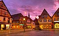
Market square, autumn 2010

Catholic parish church St. Kilian and Georg, 2005
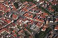
Aerial view of the city center with town hall and city tower, 2005


Gasthof Adam Riese , birthplace of Johann Baptist Schubert, 2010

Bronze sculpture of the mathematician Adam Riese

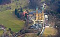
Banz Monastery, 2009
Fourteen Saints, 2009


Architectural monuments
Regular events
- Big SKK carnival ball (January)
- Staffelsteiner car spring (March)
- Obermain Marathon (April)
- Classic car meeting or classic car friends (May / June)
- Shooting Festival (June)
- Since 2017 the songwriting festival " Lieder auf Banz " has been taking place against the backdrop of Banz Monastery (July)
- Old Town Festival (end of July)
- Bad Staffelsteiner Bierbrauerfest with all 10 breweries active in the city area on Maria Himmelfahrt (15th August)
- Staffelstein-Kommers of the Coburg Old-Men-Seniors-Convent and the Corpsphilisterverband Bamberg (September)
- Brass Music Highlights (October 3rd)
- Cult party (Saturday before 1st Advent)
- Bad Staffelsteiner Advent Market (1st Advent weekend)
Economy and Infrastructure
traffic
The Bad Staffelstein station is located on the route Bamberg-Lichtenfels , which leads in the direction of Coburg, Saalfeld and yard.
Authorities
- Office of the Office for Food, Agriculture and Forests Coburg
Baths
- Aquariese (leisure pool)
- Obermain-Therme (thermal bath)
- Bad Staffelstein swimming lake
clinic
- THERAmed rehab and health center Bad Staffelstein (outpatient rehab orthopedics, EAP, rehabilitation aftercare, physiotherapy, occupational therapy)
- Schön Klinik Bad Staffelstein (orthopedics, neurology and psychosomatics ) ⊙
education
- Adam Riese School (elementary and middle school)
- Ivo Hennemann Primary School
- Viktor-von-Scheffel-Schule (Bad Staffelstein State Realschule)
- Vocational school for home economics and child care St. Kunigund (Vierzehnheiligen)
- Education center of the BAFzA
Breweries
- Staffelberg Bräu GmbH & Co. KG, Loffeld , owner of the Geldner-Wehrfritz family, 15,000 hl annual production
- Brewery Trunk , Vierzehnheiligen , owned by the Trunk family, 10,000 hl annual production
- Hetzel Brewery, Frauendorf , owner Anton Hetzel, 3000 hl annual production
- Metzgerbräu, Uetzing , owner Manfred Reichert, 900 hl annual production
- Dinkel brewery, Stublang , owned by the Dinkel family, annual production of 500 hl
- Thomann Brewery, Wiesen , owner of the Thomann family, 450 hl annual production
- Hellmuth Brewery, Wiesen , owner Georg Helmuth, 400 hl annual production
- Reblitz brewery, Nedensdorf , owned by the Reblitz family, annual production of 350 hl
- Hennemann brewery, Stublang , owner Peter Hennemann, 300 hl annual production
- Dinkel brewery, Uetzing , owner Marianne Dinkel, last 150 hl annual production, brewery operations stopped
coat of arms
"In blue on a gold-bridled silver horse jumping left over a four-tier golden stone mountain, a gold-armored knight with a silver shield and a silver spear flag, each with a continuous red cross."
Personalities
sons and daughters of the town

- The most famous Staffelsteiner is the arithmetic master Adam Ries (1492–1559). His arithmetic books were used as teaching aids in schools until the 18th century. Today we still know the saying "That does after Adam Ries (e) ...".
- Johann Jakob Joseph Sündermahler (1712–1775), lawyer and professor at the University of Würzburg
- Pankraz von Dinkel (1811-1894), Bishop of Augsburg 1861-1894
- Konrad Hofmann (1819–1890), Romanist, Germanist, Medievalist and university professor born in Banz Monastery
- Johann Baptist Schubert (1847–1920), educator and chairman of the Bavarian elementary school teachers' association
- Peter Zillig (1855–1929), teacher and educational writer
- Georg Heilmann (1892–1981), administrative lawyer, ministerial director
- Paul Böhmer (1907-1983), wrestler
- Hubert Weber (1920–2013), painter and sculptor
- Armin Geus (* 1937) biologist and medical historian
- Winfred Bogdahn (1952–2016), local politician
- Stefan Schorn (* 1971), classical philologist
Persons connected to Bad Staffelstein
- Franz Michael Rudhart (1830–1879), music writer and Bavarian district administrator in Staffelstein
- Georg Hagel (* 1968), basilica organist and regional cantor
literature
- Working group art of the cultural initiative Staffelstein (Hrsg.): Fine arts in Staffelstein . Volume 1, Staffelstein 2000, ISBN 3-9802943-8-2 .
- Working group art of the cultural initiative Staffelstein (Hrsg.): Fine arts in Staffelstein . Volume 2, Bad Staffelstein 2002, ISBN 3-935302-01-0 .
- Johann Kaspar Bundschuh : Staffelstein . In: Geographical Statistical-Topographical Lexicon of Franconia . tape 5 : S-U . Verlag der Stettinische Buchhandlung, Ulm 1802, DNB 790364328 , OCLC 833753112 , Sp. 403-404 ( digitized version ).
- Günter Dippold, Alfred Meixner (ed.): Staffelsteiner life pictures . Staffelstein 2000, ISBN 3-9802943-9-0 .
- Günter Dippold: Bad Staffelstein. Gem in the Gottesgarten on the Obermain . Stuttgart 2001, ISBN 3-09-303893-6 .
- Dorothea Fastnacht: Staffelstein: Former district of Staffelstein (= historical place names book of Bavaria, Upper Franconia . Volume 5 ). Commission for Bavarian State History, Munich 2007, DNB 986642908 , p. 350-362 .
- Heinrich Karl: Staffelsteiner Chronicle . Staffelstein 1905.
- Karl-Ludwig Lippert : District Staffelstein (= Bavarian art monuments . Volume 28 ). Deutscher Kunstverlag, Munich 1968, DNB 457441232 .
- Karl-Ludwig Ostertag-Henning: The apple tree in God's garden . Staffelstein 1998, ISBN 3-9802943-6-6 .
- Pleikard Joseph Stumpf : Staffelstein . In: Bavaria: a geographical-statistical-historical handbook of the kingdom; for the Bavarian people . Second part. Munich 1853, p. 608 ( digitized version ).
Web links
- Homepage
- Bad Staffelstein: Official statistics of the LfStat (PDF; 1 MB)
Individual evidence
- ↑ "Data 2" sheet, Statistical Report A1200C 202041 Population of the municipalities, districts and administrative districts 1st quarter 2020 (population based on the 2011 census) ( help ).
- ↑ a b c Members of the City Council. City of Bad Staffelstein, accessed on May 24, 2020 .
- ^ City of Bad Staffelstein in the local database of the Bayerische Landesbibliothek Online . Bavarian State Library, accessed on October 20, 2017.
- ↑ H. Jakob: The Klotzgau - a Slavic small district on the edge of the Franconian Alb. In: Journal of Archeology. Year 16, 1982.
- ^ Federal Statistical Office (ed.): Historical municipality directory for the Federal Republic of Germany. Name, border and key number changes in municipalities, counties and administrative districts from May 27, 1970 to December 31, 1982 . W. Kohlhammer, Stuttgart / Mainz 1983, ISBN 3-17-003263-1 , p. 694 f .
- ↑ Thomas Gunzelmann: The cultural landscape around 1840. In: Günther Dippold: In the upper Main valley on the Jura to Rodach and Itz. Self-published by Kreissparkasse Lichtenfels, Lichtenfels 1990, p. 75.
- ↑ BAD STAFFELSTEIN The week 25 years ago in the Obermain-Tagblatt: Review: Baptist Faulstich elected mayor. obermain.de, March 11, 2019, accessed on May 25, 2020 .
- ↑ A huge Adam Riese monument in the Adam Riese City , Helmut Kuzina, October 13, 2010
- ↑ Georg Lechner: Lechner's List Oelde, 2008
- ^ Entry on the Bad Staffelstein coat of arms in the database of the House of Bavarian History
Altenbanz | End | Frauendorf | Goessmitz | Basic field | Hausen | Horsdorf | Kaider | Krögelhof | Kümmersreuth | Spoon field | Nedensdorf | Neubanz | Püchitz | Romansthal | Schönbrunn | Schwabthal | Serkendorf | Barn | Stublong | Tiefenthal | Uetzing | Unnersdorf | Unterzettlitz | Fourteen saints | Weisbrem | Meadows | Wolfsdorf | Zilgendorf

Altenkunstadt | Bad Staffelstein | Burgkunstadt | Ebensfeld | Hochstadt am Main | Lichtenfels | Marktgraitz | Marketers | Michelau in Upper Franconia | Redwitz an der Rodach | Weismain
Unregulated areas: Breitengüßbacher Forst | Neuensorger Forest