
Plochingen
| coat of arms | Germany map | |
|---|---|---|

|
Coordinates: 48 ° 43 ' N , 9 ° 25' E |
|
| Basic data | ||
| State : | Baden-Württemberg | |
| Administrative region : | Stuttgart | |
| County : | Esslingen | |
| Height : | 276 m above sea level NHN | |
| Area : | 10.65 km 2 | |
| Residents: | 14,433 (Dec. 31, 2018) | |
| Population density : | 1355 inhabitants per km 2 | |
| Postal code : | 73207 | |
| Area code : | 07153 | |
| License plate : | ES, NT | |
| Community key : | 08 1 16 056 | |
| LOCODE : | DE PLO | |
City administration address : |
Schulstrasse 5-7 73207 Plochingen |
|
| Website : | ||
| Mayor : | Frank Buß (independent) | |
| Location of the city of Plochingen in the Esslingen district | ||
  |
||

Plochingen is a small town in the Esslingen district of Baden-Württemberg at the tributary of the Fils into the Neckar . It belongs to the Stuttgart region (until 1992 the Middle Neckar region ) and the European metropolitan region of Stuttgart .
geography
location
Plochingen is about nine kilometers east-southeast from the district town of Esslingen am Neckar and about 19 kilometers in the same direction from the state capital Stuttgart . The small town is located on the right banks of the Fils and runoff Neckar, which here at the mouth of the first of its four major tributaries of the characteristic Plochinger Neckar knee shows where it changes from long Northeast for a short distance to the west-northwest course. In the area of the city, three natural areas collide: the foreland of the central Swabian Alb in the southeast, the Schurwald sub- area of the Schurwald and Welzheimer Forest natural area in the north-east, and the Nürtinger-Esslinger Neckar valley, which is part of the Filder , along the larger of the two rivers in the west. The lowest point in the urban area is in the far west at the outflow of the Neckar at a little over 247 m above sea level. NN , the highest in the north at the White Stone on the Schurwald ridge at about 448 m above sea level. NN , from which forest areas cover a large part of the urban area.
Neighboring communities
Adjacent municipalities are in turn in the west the municipality Altbach , in the northwest the district town Esslingen am Neckar , in the northeast the municipality Baltmannsweiler , in the east the municipality Reichenbach an der Fils , in the southeast the municipality Hochdorf for short , in the south the city Wernau (Neckar) , im Southwest the municipality of Deizisau , all of which also belong to the Esslingen district.
City structure
The town of Plochingen and the district of Stumpenhof to the northeast of the town belong to Plochingen.
Division of space

According to data from the State Statistical Office , as of 2014.
history


antiquity
Due to the convenient location at the confluence of the Fils in the Neckar, people stayed in the area from the earliest times, which is attested by finds from the Stone Age. Weapons finds and grave goods from the Bronze Age give evidence of a settlement belonging to the urn field culture . Burial mounds from the Hallstatt period also indicate that there could have been continuous Celtic settlement up to Roman times. In classical antiquity the Romans and in the early Middle Ages the Alamanni settled on the spot.
From the Middle Ages to the 19th century
In the High Middle Ages, Plochingen was part of the Duchy of Swabia and formed part of the Neckargau. The place was in 1146 as Blochingen for the first time in a document from King Konrad III. mentioned by Hohenstaufen . There were two castles in Plochingen, but nothing is left of them. From the 12th to the 14th century, Plochingen was the seat of a noble family. In 1331 the lord of the castle Johann von Plochingen sold some property in Plochingen to the hospital in Esslingen . Since 1447, Württemberg had high jurisdiction in Plochingen, whereas the lower jurisdiction was divided between the imperial city of Esslingen and the Duchy of Württemberg until mediatization at the beginning of the 19th century. The Württemberg portion of Plochingen, originally with the Vogtei Nellingen, was subordinated to the office in Stuttgart at the beginning of the 15th century. Since the 12th century Plochingen had a market for building materials, salt and agricultural goods, including in particular wine, grain, fishing and cattle. In 1536 Duke Ulrich von Württemberg pushed through the Reformation. In 1545 the first bridge was built over the Neckar, which replaced a medieval footbridge. There was also a bridge over the Fils so that bridge tariffs could be levied. After the battle of Nördlingen , which was lost for Württemberg, the convenient location of Plochingen had a disadvantageous effect during the Thirty Years' War, as imperial troops looted the place as early as 1634 and many houses burned down. The population of about 1300 people before the war fell to about 500 after the war. In 1698 Plochingen became a post office on the imperial post line between Antwerp and Venice operated by the House of Thurn- und Taxis . In 1778 the master craftsman Johann Christian Adam Etzel (1743–1801; uncle of Gottlieb Christian Eberhard von Etzel ) built the covered wooden bridge, which then became famous in Europe, with a cantilever span of 70 meters without intermediate piers over the Neckar, which in 1905 was completely intact after the extension of the Railway station facilities had to give way. During the implementation of the new administrative structure in the Kingdom of Württemberg, the municipality came from the Stuttgart District Office to the newly established Esslingen District Office in 1808 . In 1846 the Filstalbahn was built up to Plochingen to connect to the emerging route network of the Württemberg State Railways , just one year after a train first ran in Württemberg on the route between Cannstatt and Untertürkheim . In 1888 the Swabian Alb Association was founded in the Waldhorn restaurant .
20th century
In 1905 the wooden bridge from 1778 was replaced by an iron bridge over the Neckar. On June 1, 1913, a tornado destroyed numerous buildings in Plochingen. During the district reform during the Nazi era in Württemberg , Plochingen came to the Esslingen district in 1938. After the Second World War, the community came under the American zone of occupation and was in the state of Württemberg-Baden from 1945 to 1952 . On April 13, 1948, the municipality of Plochingen was elevated to the status of a city, which from 1952 belonged to the new state of Baden-Württemberg. On July 12, 1968 the inauguration of the Neckar port in Plochingen took place. Since the S-Bahn began operating in the greater Stuttgart area on October 1, 1978, the vehicles have been technically serviced and cleaned in the Plochingen depot .
In 1998 Plochingen hosted the Baden-Württemberg State Horticultural Show .
religion
Plochingen has been evangelical since the Reformation . In addition to the Protestant parish of Plochingen , there is also a Roman Catholic parish again. In recent years a Methodist and a New Apostolic congregation have also emerged.
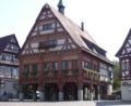
The old City Hall

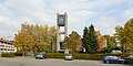
View of the Stumpenhof district
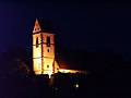
The Evangelical City Church at night
Paul-Gerhardt-Church, Stumpenhof district


Population development
The population figures are estimates, census results (¹) or official updates from the State Statistical Office ( main residences only ).
|
politics
Administrative association
Together with Altbach and Deizisau, Plochingen forms the Plochingen municipal administration association . Frank Buss, mayor of the city of Plochingen, is chairman of the administrative association.
The city of Plochingen also has its own operations: the municipal utilities , the sewage disposal company and the residential company
mayor
- 1946–1947: Gerhard Kühlkopf
- 1947–1951: August Schöck
- 1951–1969: Emil Hartung
- 1969–2008: Eugen Beck
- since 2008: Frank Buß (* 1964)
Municipal council
The municipal council consists of the elected voluntary councilors and the mayor with voting rights as their chairman. The municipal council in Plochingen has 22 members. The local elections on May 26, 2019 led to the following official final result:
| Parties and constituencies |
% 2019 |
Seats 2019 |
% 2014 |
Seats 2014 |
||
| CDU WG | Christian Democratic Union of Germany - electoral community | 31.64 | 7th | 30.75 | 7th | |
| SPD | Social Democratic Party of Germany | 26.79 | 6th | 29.78 | 7th | |
| OGL | Open Green List Plochingen eV | 22.39 | 5 | 19.06 | 4th | |
| ULP | Independent list Plochingen | 19.19 | 4th | - | - | |
| FW | Free voters Plochingen eV | - | - | 20.41 | 4th | |
| total | 100.0 | 22nd | 100.0 | 22nd | ||
| voter turnout | 55.64% | 47.01% | ||||
coat of arms
The city coat of arms is divided diagonally left five times by blue and gold. The city colors are blue-yellow.
Town twinning
Sister cities of Plochingen are
-
 Landskrona in southern Sweden, since 1971
 -
 Zwettl in the Lower Austrian Waldviertel, since 1993
 -
 Oroszlány in Hungary, since 2010
Economy and Infrastructure
traffic

The city can be reached by car in about 25 minutes from Stuttgart via federal highway 10 . At the Plochinger Dreieck , the B 313 branches off from the B 10 in the direction of Tübingen and Stockach . In addition to this motorway-like structure, two other road bridges and a pedestrian bridge span the Neckar near Plochingen.
The Plochingen train station is the traffic junction of the Deutsche Bahn on the Neckar-Alb-Bahn (Stuttgart - Tübingen - Horb ) and the Filstalbahn (Stuttgart - Ulm - Munich ). It is served by long-distance trains, regional trains and the S1 line of the Stuttgart S-Bahn . The maintenance of the railcars of the Stuttgart S-Bahn takes place in the Plochingen depot .


The Neckarhafen in Plochingen has been the end point of the navigable Neckar since July 12, 1968 . It was designed as a port for commercial inland shipping exclusively for the pure transport of goods without passenger shipping. The port area extends along two port basins. From 1954 to 1992, port director Dr. rer. pole. Heinz Kreeb. Since 1992 port director Eberhard Weiß has been entrusted with the management. Almost 20 companies with an investment volume of around EUR 100,000,000 have settled in Neckarhafen. The main goods handled are iron / steel products / scrap, animal feed / grain, mineral oil and wood. The annual goods turnover is around 1,400,000 tons.
Established businesses
_in_2005.jpg)
- German headquarters of Decathlon SA (sports retail chain)
- CeramTec GmbH ( Technical Ceramics )
- Robert Bosch GmbH (vehicle testing technology, training)
For several years now, wine has been grown again in Plochingen. The Plochinger locations are part of the Weinsteige area in the Remstal-Stuttgart area.
Educational institutions
Plochingen has a grammar school ( Gymnasium Plochingen ), a secondary school , a primary and technical secondary school , a special needs school and a pure primary school. There are also nine kindergartens in the city. There is also a GARP training center for the IHK Region Stuttgart eV in Plochingen
Culture and sights

Plochingen is located on the Württemberger Wine Road with many sights.
Buildings
- The market square with half-timbered houses, including the old town hall (1530)
- The Gothic town church of St. Blaise (1488)
- The Ottilien Chapel (1328)
- The Gablenberg House (1799)
- The Hundertwasser House "Living under the Rain Tower" (1991–1994)
- Today's town hall (1900) with the municipal gallery
- The Catholic Church of St. Konrad (1929)
- The vineyard tower
- The observation tower on the Stumpenhof
- The public toilet block "Les Toilettes" (2007) designed by Tomi Ungerer next to the Ottilien chapel
nature

- The Bühleiche at the Stumpenhof
leisure
The Parkbahn in the Neckar floodplains is a 1.5-kilometer-long parkway that is operated every weekend from Easter Monday to October.
Personalities
sons and daughters of the town
- Christian Friedrich Löw (1778–1843), mayor in Beuren, member of the state parliament
- Ludwig Friedrich Wilhelm Hallberger (1796–1879), bookseller and publisher
- Ferdinand Huttenlocher (1856–1925), sculptor and painter, specialist teacher a. a. at the Bern School of Applied Arts
- Heinz Mauser (1919–1995), chemist and professor of physical chemistry
- Gotthilf Fischer (* 1928), choirmaster, known for the Fischer choirs he founded
- Werner Niefer (1928–1993), automobile manager, CEO of Mercedes-Benz AG
- Gerhard Mahler (1930–1996), entrepreneur and politician (CDU), member of the state parliament, from 1972 to 1976 State Secretary
- Willrecht Wöllhaf (1933–1999), Swabian dialect poet and writer
- Egon Eigenhaler (* 1938), commercial artist and politician (Republican), former member of the state parliament
- Siegfried K. Wiedmann (* 1938), electrical engineer
- Herbert Henzler (* 1941), management consultant, head of McKinsey Germany (1985–1999)
- Thomas Franz (* 1953), Major General in the Air Force
- Jürgen Resch (* 1960), Federal Managing Director of Deutsche Umwelthilfe
- Dieter Haller (* 1962), ethnologist, professor of social anthropology at the Ruhr University Bochum (previously New School University / New York, University of Texas / Austin).
- Andreas Tilp (* 1963), lawyer
People related to Plochingen
- Otto Löffler (1871–1949), composer, choir director, conductor and music publisher
Trivia
In the Karl May film adaptations “ The Pyramid of the Sun God ” and “ The Aztec Treasure ”, the story of which takes place in 1864, the traveling salesman Andreas Hasenpfeffer - loyal companion Dr. Sternaus - to come from “Plochingen am Neckarstrand”. He introduces himself with the words "Andreas Hasenpfeffer from beautiful Plochingen on Neckarstrand, 2,413 inhabitants, including 99 Catholics."
The water flow of the Neckar is indicated by the Plochingen gauge . This was the only gauge of the Neckar after the inflow of the Fils in the free fall of the river until the Deizisau weir was built in 1962. To keep the traffic jam fluctuations away, a threshold was built around 100 m below the Plochingen road bridge and the water level was moved there. During the great flood in February 1970, the rubble stone threshold was destroyed. Since the construction of a new concrete sleeper was too expensive, the water flow is only calculated mathematically. The runoff values from Wendlingen am Neckar and Reichenbach an der Fils are transferred to a computer and added up. From this, the theoretical water level for the relocated gauge Plochingen is calculated and published.
The German Fire Brigade Association was founded on July 10, 1853 by the Ulm fire brigade commander Conrad Dietrich Magirus in Plochingen.
literature
- Otto Wurster: Local History Plochingen (publisher: City of Plochingen 1949)
- Otto Wurster: Eßlinger Heimatbuch for town and surroundings . Eßlingen 1931. In it: Plochingen (pp. 259–267, with city map).
- Baden-Wuerttemberg State Archive, Esslingen District (Ed.): The Esslingen District. Jan Thorbecke Verlag, Ostfildern 2009, ISBN 978-3-7995-0842-1 , Volume 2, page 377.
Web links
Individual evidence
- ↑ State Statistical Office Baden-Württemberg - Population by nationality and gender on December 31, 2018 (CSV file) ( help on this ).
- ^ The state of Baden-Württemberg. Official description by district and municipality. Volume III: Stuttgart District, Middle Neckar Regional Association. Kohlhammer, Stuttgart 1978, ISBN 3-17-004758-2 , pp. 236-237.
- ↑ State Statistical Office, area since 1988 according to actual use for Plochingen.
- ^ Leo BW Plochingen old community - location and settlement
- ↑ Castles and palaces of the Esslingen district ( Memento of the original from April 24, 2008 in the Internet Archive ) Info: The archive link was inserted automatically and has not yet been checked. Please check the original and archive link according to the instructions and then remove this notice.
- ^ A b Max Miller , Gerhard Taddey (Ed.): Handbook of the historical sites of Germany . Volume 6: Baden-Württemberg (= Kröner's pocket edition . Volume 276). 2nd, improved and enlarged edition. Kröner, Stuttgart 1980, ISBN 3-520-27602-X , p. 634.
- ^ Leo BW Plochingen Altgemeinde - Church and Religion
- ↑ Illustration from 1905 available on [1] , last accessed on June 30, 2019
- ^ City of Plochingen - From history . Retrieved January 15, 2013.
- ↑ https://www.plochingen.de/-/behoerdenwegweiser/gemeindeverwaltungsverband---plochingen-altbach-deizisau-stadt-plochingen/oe6010204
- ↑ https://www.plochingen.de/start/verwalten+_+gestalten/eigenbetriebe+der+stadt+plochingen.html
- ↑ https://www.staatsanzeiger.de/staatsanzeiger/wahlen/buergermeisterwahlen/plochingen/
- ↑ Election information for the municipal data center
- ↑ The Plochingen gauge ( memento from May 4, 2013 in the Internet Archive ) at the Electronic Waterways Information System (ELWIS)
- ^ History of the German Fire Brigade Association

Aichtal | Aichwald | Altbach | Altdorf | Altenriet | Baltmannsweiler | Bempflingen | Beuren | Bissingen on the Teck | Deizisau | Denkendorf | Dettingen under Teck | Erkenbrechtsweiler | Esslingen am Neckar | Filderstadt | Frickenhausen | Großbettlingen | Hochdorf | Holzmaden | Kirchheim unter Teck | Kohlberg | Kings | Leinfelden-Echterdingen | Lenningen | Lichtenwald | Neckartailfingen | Neckartenzlingen | Neidlingen | Neuffen | Neuhausen on the Fildern | Notzingen | Nürtingen | Oberboihingen | Ohmden | Ostfildern | Owen | Plochingen | Reichenbach an der Fils | Schlaitdorf | Unterensingen | Weilheim an der Teck | Wendlingen am Neckar | Wernau (Neckar) | Wolfschlugen