Weddingstedt
| coat of arms | Germany map | |
|---|---|---|

|
Coordinates: 54 ° 14 ' N , 9 ° 6' E |
|
| Basic data | ||
| State : | Schleswig-Holstein | |
| Circle : | Dithmarschen | |
| Office : | Parish Landgemeinde Heider Umland | |
| Height : | 10 m above sea level NHN | |
| Area : | 17.79 km 2 | |
| Residents: | 2303 (Dec. 31, 2019) | |
| Population density : | 129 inhabitants per km 2 | |
| Postal code : | 25795 | |
| Area code : | 0481 | |
| License plate : | HEI, MED | |
| Community key : | 01 0 51 122 | |
| Office administration address: | Kirchspielsweg 6 25746 Heide |
|
| Website : | ||
| Mayor : | Dirk Haalck (FWW) | |
| Location of the municipality Weddingstedt in the Dithmarschen district | ||
Weddingstedt is a municipality in the Dithmarschen district in Schleswig-Holstein .
history
Weddingstedt was probably the meeting point of farmers from the Norderdöfft , the northern part of the farmers' republic, in the Dithmarschen peasant republic.
After the Meldorfer Dom , the second church in the region was built here; however, it was burned down in 1559 when Dithmarschen finally lost its independence. The then rebuilt St. Andrew's Church is still one of the oldest cultural monuments in the district.
On April 1, 1934 the parish of Weddingstedt was dissolved. All of their village communities, village communities and farmers became independent communities / rural communities, including their main town, Weddingstedt.
On January 1, 1969, the previously independent municipalities of Borgholz and Weddinghusen were incorporated into the municipality of Weddingstedt. Since then, the population has been between around 1700 and around 2320.
The Hamburg-Westerland railway goes through Weddingstedt. Until the beginning of the 1980s there was also a stop in Weddingstedt.
The municipality was until the merger with the office parish county Heide-Land on January 1, 2008, the administrative seat of the office parish county Weddingstedt .
geography
The municipality of Weddingstedt is located on the Geest, right on the edge of the march. It consists of the districts Borgholz, Rüsdorf, Waldstedt, Weddinghusen and Weddingstedt.
politics
Local council, mayor
Of the 13 seats in the municipal council has SPD 2013 five seats since the local elections, the voter community FWW (CDU Weddingstedt) and the voter community KWV (Municipal Voters Association) each have four seats.
Mayor has been Dirk Haalck (FWW) since June 19, 2013
coat of arms
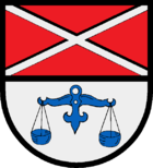
Blazon : “Divided by red and silver. Above a continuous silver St. Andrew's cross, below a blue scale. "
Economy and Infrastructure
Today Weddingstedt is mainly characterized by its proximity to the district town of Heide . On the one hand, a comparatively large number of city commuters live in Weddingstedt, and on the other hand, industrial areas have been created here that benefit from the proximity to the city and the connection to the federal highway 23 .
Attractions
The list of cultural monuments in Weddingstedt includes the cultural monuments entered in the list of monuments of Schleswig-Holstein.
Web links
Individual evidence
- ↑ North Statistics Office - Population of the municipalities in Schleswig-Holstein 4th quarter 2019 (XLSX file) (update based on the 2011 census) ( help on this ).
- ↑ State Statistical Office Schleswig-Holstein (Ed.): The population of the communities in Schleswig-Holstein 1867-1970 . State Statistical Office Schleswig-Holstein, Kiel 1972, p. 251 .
- ↑ State Statistical Office Schleswig-Holstein (Ed.): The population of the communities in Schleswig-Holstein 1867-1970 . State Statistical Office Schleswig-Holstein, Kiel 1972, p. 54 .
- ↑ Information on the local history of Weddingstedt ( Memento of the original from July 9, 2017 in the Internet Archive ) Info: The archive link was inserted automatically and has not yet been checked. Please check the original and archive link according to the instructions and then remove this notice. on the website of the parish district authority Heider Umland . Retrieved March 20, 2013.
- ↑ Schleswig-Holstein topography. Vol. 10: Timmaspe - Ziethen . 1st edition Flying-Kiwi-Verl. Junge, Flensburg 2008, ISBN 978-3-926055-92-7 , p. 180 ( dnb.de [accessed on August 9, 2020]).
- ↑ Schleswig-Holstein's municipal coat of arms


