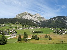
Wildhaus (pass)
| Wildhaus Pass | |||
|---|---|---|---|
|
Pass crossing towards Gams |
|||
| Compass direction | west | east | |
| Pass height | 1090 m above sea level M. | ||
| Canton | St. Gallen | ||
| Valley locations | New St. Johann | Gams SG | |
| expansion | Hauptstrasse 16 | ||
| Mountains | Appenzell Alps | ||
| profile | |||
| Ø pitch | 2.1% (331 m / 15.9 km) | 6.7% (600 m / 8.9 km) | |
| Max. Incline | 6.5% | 15% | |
| Map (Canton of St. Gallen) | |||
|
|
|||
| Coordinates | 744 837 / 229815 | ||
The Wildhauspass is a pass crossing in the canton of St. Gallen in Switzerland .
The pass height is 1090 m above sea level. M. in the center of Wildhaus in the municipality of Wildhaus-Alt St. Johann . It connects Gams in the St. Gallen Rhine Valley with Neu St. Johann and Wattwil in Toggenburg . The pass leads on the main road 16 between the Säntis and the Churfirsten .
Postbus lines on this route ensure the connection to the railway network via the stations in Buchs SG , as well as in Nesslau and Wattwil .
The orographic pass height is only 1027 m above sea level. M. , because the deepest saddle is a little south of the pass summit. (However, the data in the info box refer to the culmination point of the main street.)


