
Col de Larche
| Col de Larche | |||
|---|---|---|---|
 The place Argentera near the pass |
|||
| Compass direction | northwest | Southeast | |
| Pass height | 1991 m | ||
| region | Department Alpes-de-Haute-Provence | Province of Cuneo | |
| Watershed | Ubayette → Ubaye → Rhone | Stura di Demonte → Tanaro → Po | |
| Valley locations | Saint-Paul-sur-Ubaye | Pietraporzio | |
| expansion | D900 |
|
|
| Mountains | Cottian Alps / Maritime Alps | ||
| profile | |||
| Ø pitch | % (? m / 16.1 km) | % (? m / 18 km) | |
| Max. Incline | 4.2% | 4.4% | |
| map | |||
|
|||
| Coordinates | 44 ° 25 '18 " N , 6 ° 53' 55" E | ||

The Col de Larche ( double . Col de Larche , ital . Colle della Maddalena ) is a 1,991 m high, but in the course of relatively flat road crossing between France and Italy . It connects the French community of Barcelonnette with the city of Cuneo in Italy. On the French side, the pass road follows the Vallée de l'Ubaye and then flows into the Valle Stura di Demonte in Italy . The pass lies between the Alpine peaks of Tête de Moise ( 3104 m ) in the northeast and Tête de l'Enchastraye ( 2954 m ) in the south and is considered the border between the Cottian Alps in the north and the Maritime Alps in the south.
The next road crossing in the north is the Col d'Agnel , in the south the Col de la Lombarde .
On the Italian side just below the top of the pass is the 360 meter long Lago della Maddalena ( 1974 m slm ). It is the headwaters of the Stura di Demonte .
Illustrations
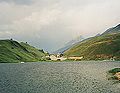
Lago della Maddalena with a view of the top of the pass

Web links
Individual evidence
Agnel • Allos • Andrion • Aravis • Bonette • Braus • Cayolle • Champs • Colle-Saint-Michel • Colombière • Croix de Fer • Croix-Fry • Cuillole • Galibier • Gets • Glandon • Granon • Iseran • Izoard • Jambaz • Joux Plane • Joux Verte • Larche • Lautaret • Lebraut • Lombarde • Madeleine • Saint Martin • Méraillet • Mollard • Mont Cenis • Montets • Montgenèvre • Morgins • Moutière • Ornon • Pré • Petit Saint-Bernard • Pontis • Ramaz • Roselend • Rousset • Saisies • Télégraphe • Tende • Turini • Valberg • Vars
Agnello • Aprica • Assietta • Aurine • Borcola • Bordala • Brennero / Brenner • Brocon • Cadibona • Campo Carlo Magno • Campolongo • Camporosso (Saifnitzer) • Carnizza • Castrin / Hofmahd • Cereda • Ciampigotto • Cibiana • Cimabanche • Coe • Colombardo • Croce d'Aune • Croce Domini • Crocette • Costalunga / Karer • Duran • Eira • Eores / Kofel • Esischie • Erbe / Würz • Falzarego • Fauniera • Fedaia • Finero • Finestre • Foppa • Foscagno • Furcia / Furkel • Fusine (Ratschacher ) • Gavia • Gardena / Grödner • Giau • Gola / Klamml • Gran San Bernardo • Kreit • Lavazè • Livigno • Lombarda • Lúsia • Lys • Maddalena • Manghen • Mauria • Mendola / Mendel • Mont Rest • Monte Croce / Plöcken • Monte Croce di Comélico / Kreuzberg • Monte Giovo / Jaufen • Mortirolo • Nevea • Nigra / Niger • Palade / Gampen • Pampeago / Pale / Reiter • Pénnes / Penser • Pian delle Fugazze • Piccolo San Bernardo • Pordoi • Pramollo (Nassfeld) • Predil • Resia / Reschen • Rolle • Russis • Rombo / Timmel • Sampeyre • San Antonio • San Boldo • San Giovanni • San Lugano • San Marco • San Pellegrino • Santa Maria (Umbrail) • Sella • Sestriere • Sommo • Spluga (Splügen) • Stalle / Staller • Staulanza • Stelvio / Stilfser • Tanamea • Tenda • Tonale • Tre Croci • Tremalzo • Valles • Valcavera • Valparola • Vezzena • Vivione • Zovo