Geography of Carinthia
The geography of Carinthia , the southernmost Austrian state, is shaped by its location in the Eastern Alps and by the Klagenfurt Basin , the largest inner-Alpine basin landscape . Most of the cities and the Carinthian lakes, which are important for summer tourism, are located in the Klagenfurt Basin .
location
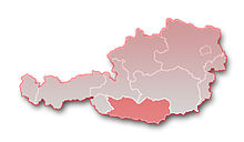
Carinthia forms roughly a rectangle and extends from north to south for around 70 km (from 46 ° 23 'to 47 ° 08' north latitude). The west-east extension is around 180 km from 12 ° 40 'to 15 ° 03' east longitude. With an area of 9,536 km², it is the fifth largest of the nine Austrian federal states.
Carinthia is bordered by East Tyrol in the west, Salzburg in the north-west , Styria in the north-east and east, and Slovenia and the Italian regions of Friuli-Venezia Giulia and Veneto in the south . The national border is almost entirely formed by mountain ridges: in the north by the Hohe Tauern and the Gurktal Alps, in the east by the Koralpe, in the south by the Carnic Alps and the Karawanken, in the west by the Lienz Dolomites and the Schober group.
The narrowing of the state area roughly in the middle to only 44 km, together with the different terrain forms, results in the subdivision into the Upper Carinthia , which is characterized by the high mountains, and the Lower Carinthia , which is dominated by the Klagenfurt Basin and extensive river valleys . The border runs roughly from Königstuhl (Gurktal Alps) in the north to the Mittagskogel (Karawanken) in the south, so Villach is on the border line. The term Central Carinthia, on the other hand, is less clearly defined, mostly referring to the area between the Nockberge and Saualpe.
Large landscapes and spatial units
Mountains
Carinthia is bordered by mountains all around. While Upper Carinthia is characterized by high mountains, Lower Carinthia is dominated by the Lavanttal Alps with less high peaks. The Drau, which flows lengthways through the country, separates the primary rock region (north) from the limestone Alps (south). The exception to this scheme is the Goldeck , the only primary rock south of the Drau.
Central Alps
The Carinthian mountain ranges of the Central Alps are:
Hohe Tauern
The Hohe Tauern are divided into:
- Glockner Group : The Glockner Group is the highest mountain group in Carinthia. The highest peak of the Glockner group and at the same time the highest peak in Austria is the Großglockner (3,798 m). The Glockner group is heavily glaciated, the largest glacier is the Pasterze. The Grossglockner High Alpine Road runs east of the group .
- Schobergruppe : The highest mountain in this glaciated mountain group is the Petzeck (3,283 m).
- Sonnblickgruppe or Goldberggruppe : The highest peak in this group is the Hocharn (3,254 m). Other peaks are the Hohe Sonnblick (3,105 m) and the Schareck (3,122 m).
- Kreuzeck group : The highest peak of the Kreuzeck group is the Polinik (2,784 m). Other peaks are the Kreuzeck (2,702 m), the Hochkreuz (2,708 m) and the Scharnik (2,665 m).
- Ankogel Group : The highest mountain in this group is the Hochalmspitze (3,360 m). The second highest peak in this group is the Ankogel (3,246 m). The Ankogel group is also glaciated.
- Reisseckgruppe : The Reisseckgruppe, which adjoins the Ankogelgruppe to the southeast, has the Reisseck (2,955 m) as its highest peak . Other peaks are the Tristenspitze (2,929 m) and the Gmeineck (2,592 m).
Gurktal Alps
The Gurktal Alps extend from the Liesertal in the west to the Neumarkter Sattel in the east and from the Murtal in the north to the Untere Drautal and the Klagenfurt Basin in the south. The highest mountain in the mountain range is the Eisenhut (2,441 m). They are divided into:
- Nockberge : The highest peak is the Rosennock (2,440 m). Other peaks are the Große Königsstuhl (2,336 m), Rinsennock (2,334 m), the Moschelitzen (2,310 m), the Schwarzwand (2,214 m), Millstätter Alpe (2,091 m), and the Wöllaner Nock (2,145 m).
- Metnitz Mountains between Mur and Metnitztal: The highest peak is the Pranker Höhe (2,166 m).
- Mödringbergzug between Metnitz and Gurktal.
- Wimitzer Mountains between Gurk and Glantal: The highest peak is the Schneebauer Berg (1,338 m).
Saualpe

The Saualpe and then the Carinthian part of the Seetal Alps in the north lie between the Görtschitztal in the west and the Lavanttal in the east. The highest peak of the Saualpe is the Ladinger Spitz (2,079 m).
Styrian border mountains
The Carinthian part of the Styrian Randgebirge separates the Lavant valley in the west from the western Styrian hill country in the east. The Stub and Packalpe is north of the Packsattels. The highest peak is the Ameringkogel (2,187 m). The Koralpe extends from the Packsattel to Lavamünd. Its highest peak is the Große Speikkogel (2,140 m).
Southern Limestone Alps
The mountain ranges south of the Drau belong - with the exception of the Goldeck-Latschur group - to the Southern Limestone Alps :
Gailtal Alps
The Gailtal Alps between the Drau and Gail are divided into the Lienz Dolomites from the western border to the Gailbergsattel . To the east are the Reisskofel Group (between Gailbergsattel and Gitschtal), the Goldeck-Latschur Group (between Weissensee-Weissenbach and Drautal, mostly crystalline), the Spitzegel Group and the Dobratsch . The highest peak in the Gailtal Alps is in East Tyrol and is the Große Sandspitze (2,772 m). Other peaks: Spitzkofel (2,717 m), Tamerlanhöhe (2,377 m), Reißkofel (2,371 m), Latschur (2.236 m), Goldeck (2.142 m), Spitzegel (2.119 m) and Dobratsch (2,166 m).
Carnic Alps
The Carnic Alps form the natural border between Carinthia and Italy . They lie south of the Gailtal and extend in the east to the Gailitz. The highest peaks are: Hohe Warte (2,780 m), Zwölferspitze (2,593 m), Pfannspitze (2,678 m), Trogkofel (2,279 m) and Gartnerkofel (2,195 m).
Karawanken
The Karawanken are connected to the Carnic Alps in the east and form the southern border between Carinthia and Slovenia . Your highest mountain is the high chair (2,237 m). The Mittagskogel (2,143 m) and the Petzen massif (2,113 m) lie in the Karawanken .
Steiner Alps
Carinthia also has a small part of the Steiner Alps , which are located south of the Karawanken mainly in Slovenia.
Klagenfurt Basin
The Klagenfurt Basin extends from Villach to Lavamünd, from the Rosental in the south to Feldkirchen and Althofen in the north. It is the main settlement area of the state with the cities of Klagenfurt , Villach , Sankt Veit an der Glan , Völkermarkt and Feldkirchen .
The basin is divided into valleys and basins, which are separated by hills and low mountain ranges. The following is an - incomplete - overview.
Lowlands are:
- The Villacher Feld around the city of Villach.
- The Rosental between Villach and the Gurk estuary lies between Karawanken in the south and Sattnitz in the north.
- The Klagenfurt field lies between Klagenfurt and Völkermarkt.
- The Zollfeld lies between Klagenfurt and St. Veit.
- The Krappfeld stretches from St. Veit to Althofen .
- The Jauntal lies between the Vellach estuary near Goritschach and Schwabegg south of the Drau and extends as far as the Karawanken.
Hills and mountain ranges are:
- The Sattnitz lies between Wörthersee and Drau.
- The Magdalensberg is located southeast of St. Veit.
- In many cases, the Ossiacher Tauern are included in the Klagenfurt Basin.
- The Glantaler Bergland with the Ulrichsberg lies north of Klagenfurt.
Rivers and valleys
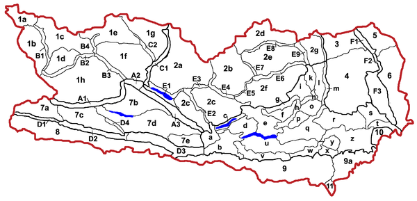
The largest river in Carinthia is the Drau (1). It reaches Carinthia near Oberdrauburg and flows through a number of valleys and basins.
- The Upper Drautal extends from Oberdrauburg via Greifenburg and Steinfeld to Sachsenburg and lies between the Kreuzeck mountain ranges in the north and the Drauzug in the south.
- The subsequent Lurnfeld extends to Spittal.
- The Lower Drautal extends to Villach and runs between the Gailtal Alps in the south and Mirnock in the north from northwest to southeast.
- The rest of the course of the Drau lies in the Klagenfurt Basin. These include the Villacher Feld ; the Rosental between Sattnitz in the north and Karawanken in the south with St. Jakob im Rosental, Ferlach and Maria Rain ; the Jauntal ; and the deeply cut Lavamünder Drautal . The Drau leaves Carinthia around 4 km southeast of Lavamünd .
The main tributaries of the Drava are in the order of their confluence:
- The Möll (2) rises at the foot of the Großglockner, is 80 km long and flows into the Drau at Möllbrücke . The Mölltal lies between the Sonnblick and Reisseck groups in the north and the Schober and Kreuzeck groups in the south. The largest towns are Heiligenblut , Winklern and Obervellach .
- The Lieser (3) rises below the Kleiner Sonnblick. It flows through the Pöllatal , which merges into the Katschtal at Rennweg , which in turn merges into the Liesertal after the confluence of the Malta at Gmünd . The Lieser separates the Hohe Tauern from the Gurktal Alps and flows into the Drau at Spittal .
- The Malta (4) rises below the Ankogel, is dammed up by the Kölnbreinsperre and flows through the Maltatal over a length of 38 km . The valley is bordered in the west by the Reisseckgruppe, in the east by the Rittenck der Hafnergruppe. The only bigger place is Malta . The Malta flows into the Lieser in Gmünd.
- The Tiebel (5) rises at Auserteuchen north of the Gerlitzen, flows around it in a wide arc over Himmelberg and Feldkirchen and flows into the Ossiacher See. The Ossiacherseebach flows into the Treffner Bach , this one near Villach into the Drau.
- The Gail (6) rises in East Tyrol and flows over a length of 122 km through the Lesachtal (to Kötschach-Mauthen), the Upper Gailtal (to Hermagor) and the Lower Gailtal (to Villach) and flows into the Drau in Villach.
- The Gailitz (7) rises near the Nevea saddle in Italy and flows from Thörl-Maglern on Austrian territory. After a few kilometers it flows into the Gail at Arnoldstein .
- The Gössering (8) flows through the Gitschtal and joins the Gail south of Hermagor.
- The Vellach (9) rises in the Steiner Alps and flows through the Vellach valley and the Sittersdorf valley of the Jauntal. It flows into the Drava near Gallizien .
- The Gurk (10) is the largest river after the Drava and is 120 km long. It rises on the Lattersteig, flows through the Obere Gurktal (main town Patergassen ), the Enge Gurk (Sirnitzer Gurkenge) and the Middle Gurktal (main town Strasbourg ) in the Gurktal Alps. In the Klagenfurt Basin, it flows through the Krappfeld between Althofen and Launsdorf as well as the Klagenfurt Feld and flows into the Drau at the Völkermarkt reservoir.
- The Glan (11) rises in the Ossiacher Tauern. It flows through Feldkirchen , the Glantal (to St. Veit), the Zollfeld and the Klagenfurt Feld and flows into the Gurk above Grafenstein .
- The Wimitz (12) rises from the Goggau lake , flows through the Wimitz mountains and flows into the Glan in St. Veit.
- The Görtschitz (13) is created in Hüttenberg by the confluence of two streams. It flows through the Görtschitztal and flows into the Gurk at Brückl .
- The Metnitz (14) rises on the Flattnitz , flows through the Metnitztal and from Friesach the Friesacher Feld and flows into the Gurk at Althofen. The largest places are Metnitz and Friesach.
- The Glan (11) rises in the Ossiacher Tauern. It flows through Feldkirchen , the Glantal (to St. Veit), the Zollfeld and the Klagenfurt Feld and flows into the Gurk above Grafenstein .
- The Wölfnitz (16) rises near the Ladinger Spitz on the Saualpe, flows through the town of the same name as well as Griffen and Ruden and flows into the Drau at St. Nikolai.
- The Lavant (17) rises in Styria on the Zirbitzkogel . Between the Seetal Alps and Saualpe in the west and the Pack and Koralpe in the east, it flows through the Upper Lavant Valley , the Twimberger Graben and the basin-like Lower Lavant Valley . After 64 km it flows into the Drau in Lavamünd. The largest towns are Bad St. Leonhard , Wolfsberg and St. Andrä .
The area valley in the Nock Mountains between Radenthein and Villach cannot be clearly assigned to a river. The northern part of the Brennsee northwards is drained by the Feldbach, the larger southern part from the Afritzer See southwards from the Afritzerbach, which flows into the Treffner Bach.
Lakes
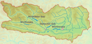
Carinthia has around 1270 lakes, mostly tongue basin lakes with a total area of around 60 km², of which the four largest alone take up almost 50 km²:
- Wörthersee (area: 19 km²): The Wörthersee is located west of Klagenfurt. Villages on the Wörthersee are Velden , Pörtschach and Krumpendorf .
- Millstätter See (area: 13 km²): Millstätter See is located northeast of Spittal / Drau. Places on Lake Millstatt are Millstatt and Seeboden .
- Ossiacher See (area: approx. 11 km²): Ossiacher See is northeast of Villach. Places on Lake Ossiach are Ossiach and Bodensdorf .
- Weissensee (area: 6 km²): The Weissensee is north of Hermagor. The only place on Lake Weissensee is Techendorf .
For further information see Carinthian Lakes .
See also
- List of Slovenian field names in Carinthia
- Ordinance on Slovenian place names
- List of municipalities in Carinthia (section Slovenian place names)
literature
- Paul Mildner, Helmut Zwander (Ed.): Carinthia - Nature. The diversity of a country in the south of Austria. Publishing house of the Natural Science Association for Carinthia, 2nd edition Klagenfurt 1999. ISBN 3-85328-018-8
- Herbert Paschinger: Carinthia. A geographic study of the country. Two volumes. Publishing house of the State Museum for Carinthia, Klagenfurt 1976 and 1979.
Web links
- Digital Carinthia atlas of the state government
- Slovenian field and farm names in Carinthia . nationalagentur.unesco.at
- Carinthian place names as a cultural asset
- Slavic and Slovenian (Alpine Slavonic) place names in Austria (focus on Carinthia)
Individual evidence
- ↑ Martin Seger: Introduction to regional studies and geographical structure . In: Paul Mildner, Helmu Zwander (Ed.): Carinthia - Nature. The diversity of a country in the south of Austria . 2nd Edition. Publishing house of the Natural Science Association for Carinthia, Klagenfurt 1999, ISBN 3-85328-018-8 , p. 25-62, especially 34 f .


