
Munster (Haut-Rhin)
| Muenster | ||
|---|---|---|
.svg)
|
|
|
| region | Grand Est | |
| Department | Haut-Rhin | |
| Arrondissement | Colmar-Ribeauvillé | |
| Canton | Wintzenheim | |
| Community association | Vallée de Munster | |
| Coordinates | 48 ° 2 ' N , 7 ° 8' E | |
| height | 341-794 m | |
| surface | 8.64 km 2 | |
| Residents | 4,606 (January 1, 2017) | |
| Population density | 533 inhabitants / km 2 | |
| Post Code | 68140 | |
| INSEE code | 68226 | |
| Website | http://www.ville-munster68.fr/ | |

Munster (German Münster im Alsace , Alsatian Mínschter ) is a French city in the Haut-Rhin department in the Grand Est region (until 2015 Alsace ). The municipality has 4606 inhabitants (as of January 1, 2017) and an area of 8.64 km².
geography
_2008.JPG)
Munster is located in the Vosges at the intersection of two valleys (a larger one in the south towards Metzeral and a smaller one in the northwest towards Soultzeren ), which unite here to form the valley of the Fecht or Münstertal (Vallée de Munster). In the west, the summit of the Hohneck rises 1,362 meters above sea level. To the east the Fecht flows into the plain towards Colmar , which is about 20 km away. The D 417 runs through Munster from Colmar over the gorge pass (1139 m above sea level) to Gérardmer . Munster also has a train station on the Colmar – Metzeral railway line .
history
Around 660 AD, Benedictine monks founded the St. Gregory monastery (Latin monasterium ) near Munster , after which the town and the valley were named. In 1308 the city was walled. In 1354 the city merged with other cities in Alsace to form the League of Ten . In the 16th century, the city joined the Reformation . Mayor Friedrich Zeringer signed the Lutheran concord formula of 1577 for the “City Council of Münster in S. Georgental” .
In the Thirty Years War Munster and its surroundings were badly affected. In 1791, under the influence of the French Revolution , the monastery was dissolved.
From 1871 until the end of World War I , Munster belonged to the German Empire as part of the realm of Alsace-Lorraine and was assigned to the Colmar district in the Upper Alsace district . In the First World War, 85% of the city was destroyed. The area also suffered greatly during World War II . Munster was captured by the Allies on February 5, 1945 .
- Population development
| year | 1910 | 1962 | 1968 | 1975 | 1982 | 1990 | 1999 | 2007 | 2017 |
| Residents | 5974 | 4965 | 4888 | 4932 | 4661 | 4657 | 4884 | 4990 | 4686 |
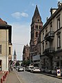
View of the street with the Protestant and Catholic Church in the background

Protestant Church
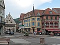
View of: the Place du Marché - the Rue Saint-Gregoire - the Grand 'Rue with the town hall

town hall
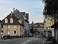
Street view: Rue du 9e Zouaves


politics
Munster is a member and seat of the municipality association Vallée de Munster . In addition to the mayor, the town council has six councilors and 20 other people.
Partnerships
Munster maintains city partnerships to
- Ihringen in Baden-Württemberg (Germany)
- Romanèche-Thorins in the Saône-et-Loire department (France)
economy
Munster was a center of the textile industry for a long time , until the decline brought this branch of the economy to a standstill. Furthermore, the plays forestry an important role.
In addition, tourism is increasingly an economic factor. Munster is located in the Ballons des Vosges Regional Nature Park , whose park administration and exhibition center are located here.
The place is famous for the production of the strong smelling Munster cheese , which is made here. The dairy farming required for this has an alpine character: the dairy cattle spend the summer on the mountain heights and overwinter in the valley. For this reason, the area is also nicknamed Kleini Schwitz (Little Switzerland).
Personalities
- Thomas Gyrfalk († 1559), Swiss reformer
- Andreas Lamey (1726–1802), historian and librarian
- Caroline Hartmann (1807–1834), pianist, student of Frédéric Chopin
- Jean Ruhland (1834–1907), mayor from 1886 to 1907, member of the Reichstag
- Martin Graff (* 1944), publicist
literature
- Le Patrimoine des Communes du Haut-Rhin. Flohic Editions, Volume 2, Paris 1998, ISBN 2-84234-036-1 , pp. 891-898.
See also
Web links
- Official website (French)
Individual evidence
- ↑ Municipal directory Germany 1900 - Colmar district ( Memento of the original from February 21, 2016 in the Internet Archive ) Info: The archive link was inserted automatically and has not yet been checked. Please check the original and archive link according to the instructions and then remove this notice.