
Deaf
| Deaf | ||
 Map of the deaf course |
||
| Data | ||
| Water code | EN : 246 | |
| location |
Southwest German step country
Baden-Württemberg Bavaria |
|
| River system | Rhine | |
| Drain over | Main → Rhine → North Sea | |
| source | about 0.5 km east of Rot am See - Weikersholz 49 ° 15 ′ 0 ″ N , 10 ° 6 ′ 53 ″ E |
|
| Source height | approx. 447 m above sea level NN | |
| muzzle | in Wertheim in the Main Coordinates: 49 ° 45 '48 " N , 9 ° 30' 49" E 49 ° 45 '48 " N , 9 ° 30' 49" E |
|
| Mouth height | 133.5 m above sea level NN | |
| Height difference | approx. 313.46 m | |
| Bottom slope | approx. 2.4 ‰ | |
| length | 129.1 km from Klingenbrunnen | |
| Catchment area | 1,809.29 km² | |
| Discharge at the Archshofen A Eo gauge : 286 km² Location: 89.482 km above the mouth |
NNQ (08/17/1993) MNQ MQ Mq |
50 l / s 340 l / s 2.18 m³ / s 7.6 l / (s km²) |
| Discharge at the Bad Mergentheim A Eo gauge : 1017 km² Location: 51.99 km above the mouth |
NNQ (10/17/1991) MNQ MQ Mq |
500 l / s 1.44 m³ / s 6.61 m³ / s 6.5 l / (s km²) |
| Discharge at the Tauberbischofsheim A Eo gauge : 1583 km² Location: 32.142 km above the mouth |
NNQ (09/01/1991) MNQ MQ Mq |
1.23 m³ / s 2.74 m³ / s 9.53 m³ / s 6 l / (s km²) |
| Medium-sized cities | Bad Mergentheim , Wertheim | |
| Small towns | Rothenburg ob der Tauber , Creglingen , Röttingen , Weikersheim , Lauda-Königshofen , Tauberbischofsheim | |
 The Tauber near Waldenhausen (Wertheim) |
||
The Tauber is a river in southern Germany on both sides of the border between Baden-Württemberg and Bavaria . It rises at the west foot of the Frankenhöhe , flows in a north-westerly direction through the Franconia region and flows into the Main from the left and south-east in Wertheim .
Surname
In the first documentary mentions, the Tauber is referred to as tubri (gowe) (= Tauber (gau)) and dubra (goe). The name is derived from the Celtic word dubr (or Pl . : dubra ) for water. Other derivations explain it by Dubron (Celtic) meaning fast moving water . The Celtic word dubr goes back to the Indo-European language root dhav (= wash, flow), which is why one can assume that flowing water is meant. In today's Welsh (Cymric), dwfr simply stands for the word water, which corresponds to the word dour (= dowr) in Cornwall . Several place names like Dover in Great Britain are considered anglicized forms of it. In Great Britain there is also the place name Doverdale (a parish near Droitwich , a place in Worcestershire ), which not only resembles the word Taubertal aurally and externally, but probably has an analogous word origin (Dover and Tauber both from Kelt. Dubr- , Dale and Tal both later added Germanic explanatory word part). Some attribute Tauber to the Celtic word dubo (= black), which, however, is to be regarded as linguistically and factually unfounded.
geography
History of origin
The valley line of the Tauber traces an earlier tributary of the original Danube , which flowed against the current direction of flow to the southeast. Parts of today's Main Square also belonged to it . Before the Pleistocene , the Taubertal was wider and flatter. Today's narrow valley was only formed during the cold ages in connection with extensive tectonic uplifts. Presumably, the Taubertal was also included in the phases of the Main's valley filling. The most recent formation processes in the Taubertal can also be seen. For example, the St. Achatius Chapel in Grünsfeldhausen is now more than three meters below the level of the floodplain , which is due to the deposits of floodplain clay , which raised the valley floor by at least nine meters over the course of several centuries.
Decisive for the emergence of the relief in the Taubertal and in the catchment areas of its tributaries are the extensive soil erosion, which is anthropogenic and caused by heavy rain events , as well as the linear soil erosion in the small ravines , blades , notches and gorges on the steep slopes of the Tauber. Both processes have both natural causes (geological subsoil, slope, soil type, precipitation) as well as those set by the people involved (agriculture, type of soil cultivation such as viticulture or arable farming, clearing, pasture management, road construction). Soil erosion such as soil erosion are due to historical evidence u. a. proven in the Wertheim-Bronnbach State Archives. These describe the soil damage since the late Middle Ages, which was particularly intense in the 18th century.
In addition, the landscape also shows evidence of the erosion of soil in the form of forest edge steps, arable terraces and especially the stone bars on the vineyards that are now often abandoned. Cross-sections on the stone bars show the ground surface preserved at its original height under the reading ceiling. In addition to the stone bars, the soil was constantly loosened by the cultivation of the vine and thus exposed to rinsing off by rain. A loss of soil on vineyards of up to 150 centimeters in historical time can be read from such outcrops. The complementary deposits of these amounts of soil in the alluvial clay layers of the Taubertal have already been pointed out above.
source

During the 1970s, a difference of opinion between Wettringen in Bavaria and Weikersholz near Rot am See in Baden-Württemberg over the question of where the Tauber actually came from reached its peak. Since the blade fountain marked with a stone near Weikersholz is the uppermost spring that pours constantly, this fountain has been regarded as the origin of the Tauber since 1976. From here, about half a kilometer east of Weikersholz, the river has a length of about 129.1 km, a trench upper course, which then brings its length to 131.6 km, arises on the northeast edge of the Espan forest about half a kilometer northwest at around 467 m above sea level NN .
Further course


Less than a kilometer below its source, the Tauber crosses into Bavarian Middle Franconia and then flows in a north-northeastern direction through Wettringen and Diebach to Gebsattel , with a short section in Baden-Württemberg at the Thomasmühle (Rot am See municipality). From Gebsattel it directs its course to the north-northwest. After the inflow of the shameful magicians , it begins to dig its valley deep into the layers of shell limestone , initially in tight loops. In one of these loops, she passes Rothenburg ob der Tauber , which is 50 meters above the valley floor on her right. Below Tauberzell it changes at the Holdermühle to Baden-Württemberg and flows past Archshofen and Craintal , then through the town of Creglingen . Once again it crosses Bavarian soil ( Lower Franconia ) around Bieberehren , Röttingen and Tauberrettersheim in a north-facing arc , before it finally crosses to Baden-Württemberg.
Below Weikersheim , it initially flows for a short stretch to the west, but turns to the northwest at Bad Mergentheim, about 10 km away (as the crow flies), and continues on this course. Your valley widens more and more to its next 20 km; between Tauberbischofsheim and Werbach in Impfingen, the valley floor reaches its maximum width of around one and a half kilometers. Immediately below Werbach it narrows again to almost only a tenth of this value in some places, the river here again creates a deep meander valley , this time in the red sandstone . This winding and unsettled section stretches for 23 kilometers of the river (as the crow flies only a little over 12 km), at its end the Tauber finally reaches Wertheim and flows there from the left into the Main.
The river has a length of 131 kilometers from the Klingenbrunnen source to the mouth.
Catchment area and tributaries

The catchment area of the Tauber covers around 1,800 square kilometers, 660 of which are in Bavaria. The Tauber drains larger parts of the Hohenlohe plain , the Gollachgau and the Tauberland . In the south and east the catchment area borders on the Frankenhöhe and the Steigerwald , in the northwest on building land and Odenwald .
The most important tributaries are the Gollach near Bieberehren, the Vorbach near Weikersheim, the Umpfer near Königshofen and the Grünbach near Gerlachsheim. Other tributaries with lengths between 10 and 20 km are Herrgottsbach (in Creglingen), Steinach (near Bieberehren), Nassauer Bach (near Schäftersheim), Aschbach (near Elpersheim / Markelsheim), Wachbach (in Bad Mergentheim), Balbach (near Unterbalbach), Brehmbach (in Tauberbischofsheim) and Welzbach (near Werbach).
- Diagram showing the tributaries of the Tauber (length greater than 10 km)

Tauber river system
environment
Water quality
As of 2004, the Tauber was moderately exposed to its entire run in Baden-Württemberg, namely from Tauberscheckenbach to shortly after Creglingen and then again from Schäftersheim to the mouth (quality class II).
River straightening in the 19th century

In the 1860s, when the Lauda railway bridge was being built, an oxbow lake was shut down. At the end of the 20th century, the Tauber Altarm was designated as an extensive natural monument, the Altarm der Tauber, at Chausseehaus Renig ( ⊙ ; since March 10, 1992). During the construction of the Bronnbach railway bridge , an old arm of the Tauber was also shut down, so that the railway bridge only has to cross the Tauber once instead of twice. The two Tauber-Altarm parts to the left and right of the Brückendamm were at the end of the 20th century as extensive natural monuments Alte Tauber Bergrain ( ⊙ ; since December 21, 1981) and Tauber-Altarm Bergrainwiese ( ⊙ ; since March 10, 1992) expelled.
In the 1890s the Tauber near Tauberbischofsheim was straightened , which lowered the water table; As a result, the local farmers harvested less green fodder for their livestock. In order to achieve more yield again, they built water barriers and dug ditches to irrigate some sections of the meadow.
Renaturation measures in the 21st century
In 2016, the Tauber got a new river bed between the district town of Tauberbischofsheim and Impfingen. The formerly straightened Tauber was renatured to improve the conditions for fauna and flora.
- Renaturation of the Tauber between Tauberbischofsheim and Impfingen in 2016

Renaturation of the formerly straightened Tauber, meandering of the river bed

Creation of gravel banks, islands and kingfisher walls

A newly created river division near Impfingen


flora
The middle and large parts of the lower Taubertal harbor flora that is adapted to dry summer conditions. Here warmth-loving plants meet, whose original home is on the one hand the Eastern European steppe heaths and on the other hand the dry Mediterranean grasslands. Since viticulture is not carried out on a large scale here, some of these plants can still be found in sufficient numbers in various locations. The blood-red cranesbill ( Geranium sanguineum ) is characteristic of many dry grasslands and can cover large areas. The common pasque flower ( Pulsatilla vulgaris ) has several occurrences, but often consists of only a few plants. The Easter lucei ( Aristolochia clematitis ) can be found regularly. The Apennine sun rose ( Helianthemum apenninum ) has already been identified several times; it has migrated from the lower main valley . The diptame ( Dictamnus albus ) grows in large numbers , mainly on forest fringes. The feather grass ( Stipa pennata ) and the field man litter ( Eryngium campestre ) have only a few locations with larger populations. So far, very few specimens of the monkey orchid ( Orchis simia ) have been found. It may have been anointed . The orchid orchid ( Orchis militaris ) is much more common. The burnt orchid ( Orchis ustulata ) is also very rare ; it was only detected again in 2005. One of the few deposits of Lorraine linseed ( Linum leonii ) in Germany is located high above the Taubertal near Werbach . The narrow-leaved flax ( Linum tenuifolium ) is a little more common. In the Taubertal there are now more than 30 nature reserves, which is why endangered plant species find a protected area here.

Diptame
( Dictamnus albus )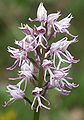
Monkey orchid
( Orchis simia )
Field man litter
( Eryngium campestre )
Helmet orchid ( Orchis militaris ), an albino


fauna
The stone bar and grassland landscapes that are common in the Taubertal are not only home to flora adapted to drought, but also to a large number of warmth-loving animals. On very warm June days in the area around Lauda-Koenigshofen, the butterfly nest can be observed. Sand lizards , red- winged and blue-winged wasteland terrors recharge their batteries on the stone bars, which heat up quickly in sunny weather, while the swallowtail prefers to visit the flowers on the surrounding dry grassland.
For the fish species that occur in the Tauber, the existing obstacles to ascent were removed at 25 of the 28 weirs. The Reicholzheim weir and the weir at the Eulschirbenmühle near Gamburg were equipped with a so-called bypass channel. In the course of the Tauber between Bronnbach and Reicholzheim, side waters were created as compensatory measures, which meanwhile represent biotopes for yellow beetles , reed warblers and, since 2006, for the beaver .
Furthermore, in the Taubertal in Baden-Württemberg the bullhead and in Bavaria also the dark blue-fly , the stag beetle , the pug bat and the great mouse-eared mouse can be found.
economy

The Taubertal is known for its viticulture. The varieties Müller-Thurgau , Silvaner , Kerner , Dornfelder , Acolon , Schwarzriesling and the specialty Tauberschwarz are grown, and the Zweigelt grape variety since 2000 . The Tauber flows through three cultivation areas, through the Baden region of Tauberfranken between Wertheim and Lauda-Königshofen , the Württemberg region in the middle (Markelsheim, Weikersheim and Schäftersheim) and the Bavarian-Franconian region in the upper reaches of Tauberrettersheim , Röttingen and from Tauberzell to Rothenburg ob der Tauber . In addition, tourism plays an important role. The “Liebliches Taubertal” cycle path from Rothenburg ob der Tauber to Wertheim am Main is particularly well-known, and besides the cities, the Bronnbach monastery in the lower Taubertal with its many terraced bank slopes is also worth seeing .
Larger industrial companies have also developed in the larger cities, predominantly the wood processing ( e.g. Weinig and Vereinigte Spezialmöbelfabriken in Tauberbischofsheim, Ruppel GmbH in Lauda, Bembé Parkett GmbH & Co. KG in Bad Mergentheim) and the glass industry (especially in Wertheim) as well as the (Precision) mechanical engineering (e.g. TREPEL Airport Equipment GmbH, the company Lauda Dr. R Wobser or Richard Kablitz & Mitthof GmbH).
traffic
Attempts to make navigable

As early as 1244 attempts were made to make the Tauber navigable. The driving forces behind this were Count Poppo and Rudolf von Wertheim, who promised the Bronnbach Monastery to make the Tauber passable for barges from the abbey to the mouth and to create a towpath for this purpose . However, since expensive locks would have been required for the Wertheim mills, the attempt failed. Similar plans were made again in the 16th century; This time the Tauber was to be made navigable from Tauberbischofsheim, so that goods from the trading cities of Rothenburg and Nuremberg could reach the Main from there on the river route. Wertheim in particular would have benefited from this, since it was off the trade routes; however, these plans were not implemented either. Planning was started again after the Thirty Years' War; this time the navigable route should extend from Weikersheim to Wertheim. The five sovereigns that were neighbors on this route - the Grafschaft Wertheim , Kurmainz , the Hochstift Würzburg , the Teutonic Order and the Grafschaft Hohenlohe - negotiated with each other from 1661. The points of negotiation included the costs and their distribution, the customs duties and the operation of the locks. An expert from Holland, who had already served the Duke of Württemberg in the expansion of the Neckar, was also present at the negotiations. According to his calculations, the total cost should be 8,000 Reichstaler, which should also be used to finance the 34 required locks. Since each rulership should do and carry out the necessary work in its own area, costs of around 1,500 Reichstalers were calculated for each rulership. In November 1662, members of all five neighbors took a ride up the Tauber from Wertheim to get an overview, whereby the Wertheim mills were already recognized as problematic cases. In the period that followed, the vegetation was removed from the bank on which the towpath was to be built; however, it turned out that the cost estimate was too optimistic. The Count of Hohenlohe hoped, for example, that a cost increase of 50% to 12,000 Reichstaler should be sufficient. The Teutonic Order continued to support the project, but other reasons led to the project not being pursued any further: The Wertheim counts feared for their mills and Kurmainz did not expect Tauberbischofsheim and Lauda to benefit significantly from the expansion. A last attempt was made in 1702; this was not implemented either.
Rail transport
With the train station in Lauda, there is an important railway junction in the middle of the Taubertal. This is where the double-track, electrified main line from Würzburg to Osterburken (and on to Stuttgart or Heidelberg ) crosses with the single-track, non-electrified Taubertal Railway between Wertheim and Weikersheim (formerly also to Creglingen), which runs from northwest to southeast and follows the course of the Tauber .
Road traffic
The Tauber also follows the B 290 between Bad Mergentheim and Tauberbischofsheim in the middle of the Taubertal . In the rest of the valley, the valley is opened up by state roads. Parts of it are part of the significant tourist Romantic Road , which in Rothenburg ob der Tauber via Tauber bridge leads from the 1330th
At Tauberbischofsheim the federal highway 81 crosses the Taubertal and provides a connection to the B 290. The girder bridge called Taubertalbrücke in the form of a box girder was built in 1968. It has a maximum pillar height of 13 m with standard spans of 55 m.
Use of hydropower
At the beginning of electrification, several direct current electricity plants were operated along the Tauber to provide local power to the neighboring cities using hydropower. The first power station in the Taubertal was the so-called. Taubermühle in Lauda, which started operations in 1889. Other power stations existed in Bad Mergentheim (from 1909), Bronnbach, Rothenburg, Röttingen and Tauberbischofsheim. Between 1920 and 1950 these small power plants were mostly abandoned in favor of mostly larger and more distant AC power plants. Today, however, there are still or again several small systems in operation that generate their electricity using water power from the Tauber:
- Electricity and power station in Rothenburg ob der Tauber, operated by the Rothenburg municipal works.
- Electricity plant Müller in Tauberrettersheim.
- Mühle & Elektrizitätswerk Karl Kuhn, which has been supplying Markelsheim with electricity since 1898.
- Hydropower plant on the Tauber for Stadtwerke Wertheim, a new power plant that has been operated by Elektrizitätswerk Linner in Engelsberg since 1992.
- Königshofen, Eckert hydropower plant from Königshofen
- Dittigheim, Walter & Marita Eckert hydropower plant from Tauberbischofsheim
- In Hochhausen near Tauberbischofsheim, one of the two 65 kW turbines of a former mill is still operational today, which is still used to power the former mill building (now the residential building).
- Bronnbach, Richard Kail hydroelectric power station from Rittersdorf
Settlement and Territorial History
See Tauberfranken .
The Tauber as namesake
The name Tauber appears in the names of several places on the river. Most prominent among these is the world-famous tourist town of Rothenburg ob der Tauber, which made the name of the river widely known. Other places that have the river in their name are Tauberscheckenbach , Tauberzell , Tauberrettersheim and the city of Tauberbischofsheim, which is known nationwide for the Olympic base for fencing . The base of the railway line is called Taubertalbahn .
The Main-Tauber district in Baden-Württemberg is also named after the river . The region along the Tauber is often also called Tauberfranken , the landscape south of the river between Bad Mergentheim and Creglingen is called Taubergrund.
The Tauber-Franken-Halle in Königshofen has been the largest event hall in the Taubertal since 1967 and is used for industrial fairs, sports competitions (e.g. handball), music events (dance floor and concerts), festivals, folk and sports festivals for the entire region. Every year in September the ten-day Königshöfer fair takes place around the hall , the largest fair in Tauberfränk. The Tauberfranken barracks in Lauda was a 20 hectare site of the Bundeswehr Air Force and was closed in 2004 as part of the nationwide reduction in the number of troops and sites of the Bundeswehr. The area is currently being converted into a commercial area, for which the city founded a development company called i_PARK TAUBERFRANKEN GmbH in 2006 .
The Liebliches Taubertal tourism association , as the umbrella organization for tourism in several districts and municipalities, markets the Taubertal with a focus on a holiday and hiking region. The term Liebliches Taubertal has been used in many brochures and advertising texts for around 60 years and has become a constant phrase in the region. There is also the officially called Tauber Cycle Path from Rothenburg to Wertheim, which has been officially expanded along the Tauber . Very close to the Taubertal bicycle route was in Weikersheim the Tauber Philharmonic Weikersheim , a concert and event hall built.
Furthermore, some, especially younger, companies use the word Tauber as part of their name, for example the company Tauber-Solar in Tauberbischofsheim. The regional savings bank is also named after the Tauber and is called Sparkasse Tauberfranken .
The regional currency Tauber Franconia has existed since 2005 .
The Taubertal 100 ultramarathon has been taking place along the Tauber every year on the first weekend in October since 2014 . Four different distances (100 miles; 100, 71 and 50 kilometers) each start in Rothenburg ob der Tauber.
Musical representation
In September 2012 the orchestral work Dubron - Die Tauber was premiered. It was composed by Roxana Littau, who depicts the Tauber as a lovely river on a summer day as well as on a winter day bathed in fog, so that melancholy moods are reflected and intensified.
See also
Individual evidence
- ↑ Wolf-Dieter Sick : Geographical land survey: The natural space units on sheet 162 Rothenburg o. D. Deaf. Federal Institute for Regional Studies, Bad Godesberg 1962. → Online map (PDF; 4.7 MB)
- ^ Horst Mensching , Günter Wagner : Geographical land survey: The natural space units on sheet 152 Würzburg. Federal Institute for Regional Studies, Bad Godesberg 1963. → Online map (PDF; 5.3 MB)
- ↑ According to the contour line image on the geodata viewer.
- ↑ Reservoir destination in the upper water of the first barrage Faulbach des Main below the mouth according to the web server of the Water and Shipping Directorate South ( Memento of the original from June 13, 2013 in the Internet Archive ) Info: The archive link was automatically inserted and not yet checked. Please check the original and archive link according to the instructions and then remove this notice. .
- ↑ a b After stationing the Steinseebach flowing into the Steinsee at LUBW-FG10 (data record entry) and an appropriate upper section up to the official and designated source.
- ↑ Directory of brook and river areas in Bavaria - Main river area, page 132 of the Bavarian State Office for the Environment, as of 2016 (PDF; 3.3 MB)
- ↑ Archshofen level values , requested from the flood forecast center , State Institute for the Environment Baden-Württemberg on February 21, 2019.
- ↑ Level values Bad Mergentheim , requested from the flood forecast center , State Agency for the Environment Baden-Württemberg on February 21, 2019.
- ^ Level values Tauberbischofsheim , requested from the flood forecast center , State Institute for the Environment Baden-Württemberg on February 21, 2019.
-
↑ a b Hugo Stang: The prehistoric and early historical settlement of the Tauberbischofsheim area and the district . In: Hugo Stang, Anton Ullrich, Wilhelm Ogiermann, Josef Kiefer, August Haun: Tauberbischofsheim . Self-published by the city administration, Tauberbischofsheim 1955, p. 51 (or p. 52).
With reference to: Albert Krieger: Topographical Dictionary of the Grand Duchy of Baden. 2nd edition, Heidelberg 1904–1905. - ↑ Hugo Stang (1955) (see above). With reference to: O. Springer: The river names of Württemberg and Baden. In: Tübinger Germanistische Schriften. 11. Vol. Stuttgart 1930, p. 63.
- ↑ Hugo Stang (1955) (see above). With reference to: Hans Krahe : Old European river names. Contributions to name research. 1st year, Heidelberg 1949–1950. P. 41.
- ^ A b Della Hooke, PH Sawyer: Worcestershire Anglo-Saxon charter bounds. Woodbridge 1990: Boydell Press. ISBN 0-85115-276-7 .
- ↑ Hugo Stang (1955) (see above). With reference to: Hans Krahe : Old European river names. Contributions to name research. 1st year, Heidelberg 1949–1950. P. 250.
-
↑ Hugo Stang (1955) (see above). With reference to:
Karl Schumacher : The river and stream names of the Tauberland and its surroundings. In: Mergentheimer Heimatblätter. 1st year, 1931, 6th
O. Springer: The river names of Württemberg and Baden. In: Tübinger Germanistische Schriften. 11. Vol. Stuttgart 1930, p. 62. - ^ A b Siegfried Albert: Water protection in the realm of the beaver . In: Main-Echo Special for the Michaelis-Messe Wertheim 2009 from October 2009.
- ^ Horst-Günter Wagner: Soil erosion in the historic agricultural landscape of the Taubertal . Würzburg geographer. Manuscripts issue 88, 182 S, Würzburg 2018
- ↑ According to LUBW-FG10 (data record entry).
- ↑ Biological water quality map 1: 350,000 of the State Institute for Environmental Protection Baden-Württemberg (PDF; 11.7 MB)
- ↑ Reserve Characteristics: Natural Monument, areally Altarm der Tauber in Chauseehaus Renig. In: rips-dienste.lubw.baden-wuerttemberg.de. Retrieved May 20, 2020 .
- ↑ Protected area profile: Natural monument, extensive Alte Tauber Bergrain. In: rips-dienste.lubw.baden-wuerttemberg.de. Retrieved May 15, 2020 .
- ↑ Protected area profile: Natural monument, extensive Tauber-Altarm Bergrainwiese. In: rips-dienste.lubw.baden-wuerttemberg.de. Retrieved May 15, 2020 .
- ↑ Fränkische Nachrichten: The Tauberwiesenwässerungsgenossenschaft: A unique piece in the Taubertal from the 19th century. Cultural monument along the Tauber . August 15, 2015. Online at www.fnweb.de. Retrieved December 18, 2016.
- ↑ Fränkische Nachrichten: Renaturation of the Tauber: Complex construction work by the Stuttgart Regional Council increases ecological diversity / costs of over one million euros. New river bed is taking shape . October 27, 2016. Online at www.fnweb.de. Retrieved December 18, 2016.
- ↑ B. Haynold: Orchis ustulata again currently in the Tauberland . In: Journal European Orchids 38 (1) 2006, ISSN 0945-7909 .
- ↑ Habitat Galgenberg ( Memento from February 3, 2015 in the Internet Archive )
- ↑ Wormental
- ^ The Taubertal - Concepts in Bavaria and Baden-Württemberg
- ↑ Source area analysis for the Liebliche Taubertal, 2009/2010 (PDF; 3.7 MB)
- ↑ Martina Heine: Big plans for the deaf . In: Wertheimer Zeitung of September 26, 2012
- ^ Touristikgemeinschaft "Liebliches Taubertal" e. V .: Chronicle of the tourism association "Liebliches Taubertal" e. V. Retrieved September 29, 2010 .
- ↑ www.Fahrrad-Tour.de: Tauberradweg: Liebliches Taubertal. Retrieved September 29, 2010 .
- ^ Tauber-Solar: Home. Retrieved September 29, 2010 .
- ^ Sparkasse Tauberfranken: Portal. Retrieved September 29, 2010 .
- ↑ Tauber-Franken e. V. - Initiative for sustainability: Der Tauberfranken. (No longer available online.) Archived from the original on April 10, 2011 ; Retrieved September 29, 2010 . Info: The archive link was inserted automatically and has not yet been checked. Please check the original and archive link according to the instructions and then remove this notice.
- ^ Taubertal 100: Taubertal 100 home page . Online at www.taubertal100.de. Retrieved October 7, 2018.
- ^ Taubertal 100: Results of the 1st Taubertal 100 in 2014 . Online at www.taubertal100.de. Retrieved October 7, 2018.
- ^ Taubertal 100: Taubertal 100 sequence . Online at www.taubertal100.de. Retrieved October 7, 2018.
- ↑ Peter Riffenach: First performed : Die Tauber . In: Wertheimer Zeitung from September 12, 2012
literature
General
- Johann Kaspar Bundschuh : Deaf . In: Geographical Statistical-Topographical Lexicon of Franconia . tape 5 : S-U . Verlag der Stettinische Buchhandlung, Ulm 1802, DNB 790364328 , OCLC 833753112 , Sp. 507 ( digitized version ).
- Carlheinz Gräter : Most graceful daughter of the Main . Franconian news, Tauberbischofsheim 1986, ISBN 3-924780-08-0 (frankonia book)
- Bernhard Lott: The Tauber from the source to the mouth . Swiridoff, Künzelsau 2005, ISBN 3-89929-048-8
Special topics
- Horst-Günter Wagner: The historical development of soil removal and small form treasure in the area of the Taubertal . In: Mitteilungen der Geographische Gesellschaft München, Vol. 46, 1961, pp. 99–149
- Georg Philippi : Explanations of the vegetation map 1: 25000 sheet 6323 Tauberbischofsheim-West . State collections for natural history Karlsruhe (ed.), State survey office Baden-Württemberg, Stuttgart 1983
- Karl Baur: Explanations of the vegetation map 1: 25000 sheet 6526 Creglingen . State Museum for Natural History Stuttgart (Ed.), State Surveying Office Baden-Württemberg, Stuttgart 1965
Web links
- Course and catchment area of the Tauber on the BayernAtlas
- Reports on the Tauber inventory
- Tauber: flood risk management plan , water system , flood characteristics , flood events , government of Lower Franconia
-
Geoportal Baden-Württemberg ( information ), especially with the partial maps / layers
- the State Institute for the Environment, Measurements and Nature Conservation Baden-Württemberg (LUBW)
- "LUBW-FG10": River 1: 10,000
- "LUBW-SG10": Standing water 1: 10,000
- "LUBW-GEZG": water catchment areas
- the State Institute for the Environment, Measurements and Nature Conservation Baden-Württemberg (LUBW)
- Sub-processing area 50 Tauber with text band (PDF; 714 kB)
- Lovely Taubertal
- Directions
- Information about the Taubertal
- Tauberbischofsheim gauge, State Institute for the Environment, Measurements and Nature Conservation Baden-Württemberg
- Level near Bockenfeld , near Archshofen , near Bad Mergentheim and near Tauberbischofsheim , HND Bavaria