Ittigen
| Ittigen | |
|---|---|
| State : |
|
| Canton : |
|
| Administrative district : | Bern-Mittelland |
| BFS no. : | 0362 |
| Postal code : | 3063 Ittigen 3048 Worblaufen |
| Coordinates : | 603 084 / 202968 |
| Height : | 526 m above sea level M. |
| Height range : | 487–688 m above sea level M. |
| Area : | 4.20 km² |
| Residents: | 11,351 (December 31, 2018) |
| Population density : | 2703 inhabitants per km² |
|
Proportion of foreigners : (residents without citizenship ) |
24.6% (2,017) |
| Mayor : | Marco Rupp (BVI - Ittigen Citizens' Association) |
| Website: | www.ittigen.ch |
|
Ittigen, Talgut |
|
| Location of the municipality | |
Ittigen ( Bern German Ittige [ ˈɪtːɪɡɘ ]) is a municipality in the Bern-Mittelland administrative district in the canton of Bern in Switzerland .
geography
The municipality of Ittigen is located to the northeast, next to the city of Bern in the lower Worblental . Neighboring communities are Moosseedorf , Bern, Bolligen , Ostermundigen and Zollikofen . The Worble flows through the community and flows into the Aare in the Worblaufen district . The highway A1 crosses the municipality in the north and west. The Grauholz motorway service station on this motorway is located in the municipality.
The highest point in the community is the Mannenberg at 688 m above sea level. The lowest point is the Aare in Worblaufen at 493 m above sea level. M.
history
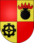
The first mention of the district of Worblaufen dates from the year 1180, the name Ittigen was first mentioned in 1380. In the Middle Ages, the paper mills and powder pounders were particularly well known beyond the state's borders, which is still reflected in the municipal coat of arms today.
Ittigen has only been an independent municipality since the split from Bolligen in 1983, before that it was only a so-called quarter municipality of Bolligen.
The name of the community probably goes back to the Ito clan .
Population development
| year | 1950 | 1960 | 1970 | 1980 | 1990 | 1999 | 2010 | 2015 | 2016 | 2017 | 2018 |
|---|---|---|---|---|---|---|---|---|---|---|---|
| Residents | 2,543 | 3,602 | 6,530 | 9,463 | 11'411 | 10,969 | 10,946 | 11,390 | 11,388 | 11,335 | 11,348 |
politics
The voting shares of the parties on the occasion of the National Council elections in 2019 were: SVP 22.2%, SP 16.1%, FDP 14.6%, GPS 12.9%, glp 11.3%, BDP 9.4%, EPP 5.0 %, CVP 3.2%, EDU (incl. DM) 1.6%.
Partner communities
Economy and business
Various DETEC federal offices are located in Ittigen , namely the ARE , the FEDRO , the FOEN , the FOT , the FOCA and the SFOE . The headquarters of Swisscom and Regionalverkehr Bern – Solothurn (RBS) are in the district of Worblaufen .
In 1619 a powder mill was operated on both sides of the Worble in Worblaufen. The plant, renamed the Eidgenössische Kriegspulverfabrik Worblaufen , was the only one to produce raw celluloid in Switzerland. In 1919 the federal government relocated the company to Wimmis and the celluloid production plant was sold to the newly founded Worbla company in 1923. Worbla AG became Gurit-Worbla AG in 1973 and part of the Gurit-Heberlein group . Starting in 2000, the plant was restructured to refine transparent plastic surfaces for the optical sector.

In a public vote in 2018, the new trains of the Bern – Solothurn RBS regional traffic were given the name “Worbla” based on Worblaufen, Worble and the former Worbla AG.
Attractions
- Several former country estates of Bernese patricians have been preserved in Ittigen, including the Neuhausgut with the high-rise study, the Thalgut and the Altikofengut with the archive of the Gosteli Foundation on the history of the Swiss women's movement.
- There are numerous contemporary works of art in the Swisscom headquarters in the “Worblaufen” district .
literature
- Hans Gugger: Ittigen, a young community with an ancient history. Ittigen municipality 1998, ISBN 3-7272-9277-6 .
Web links
- Anne-Marie Dubler : Ittigen. In: Historical Lexicon of Switzerland .
- Anne-Marie Dubler : Worblaufen. In: Historical Lexicon of Switzerland .
- Official website of the municipality of Ittigen
Individual evidence
- ↑ Permanent resident population from STAT-TAB of the BfS , municipalities see also regional portraits 2020 on bfs.admin.ch, accessed on May 29, 2020
- ↑ Federal Statistical Office Regional portraits of the municipalities Input Ittigen ; accessed on September 14, 2019
- ↑ Ittigen in numbers. Retrieved December 2, 2019 .
- ↑ Elections and Votes. Retrieved November 24, 2019 .
- ↑ RBS: The name Worbla
- ^ Esther Maria Jungo, Hans-Peter von Ah : The headquarters of Swisscom in Worblaufen near Bern. (Swiss Art Guide, No. 660). Ed. Society for Swiss Art History GSK. Bern 2000, ISBN 3-85782-660-6 .


