
Xonrupt-Longemer
| Xonrupt-Longemer | ||
|---|---|---|

|
|
|
| region | Grand Est | |
| Department | Vosges | |
| Arrondissement | Saint-Dié-des-Vosges | |
| Canton | Gerardmer | |
| Community association | Hautes Vosges | |
| Coordinates | 48 ° 5 ' N , 6 ° 56' E | |
| height | 642-1,306 m | |
| surface | 30.71 km 2 | |
| Residents | 1,522 (January 1, 2017) | |
| Population density | 50 inhabitants / km 2 | |
| Post Code | 88400 | |
| INSEE code | 88531 | |
 Location of the commune of Xonrupt-Longemer in the Vosges department |
||

Xonrupt-Longemer is a French commune in the Vosges department in the region of Grand Est (2015 Lorraine ). It belongs to the arrondissement of Saint-Dié-des-Vosges and to the Hautes Vosges community association founded in 2017 .
geography
The municipality of Xonrupt-Longemer, with 1522 inhabitants (January 1, 2017), is located at approx. 720 meters above sea level in the Vosges , immediately east of the town of Gérardmer . The municipality includes the valley of the upper Vologne including its source and the mountain lakes Lac de Longemer and Lac de Retournemer through which it flows . With an area of 76 hectares, Lac de Longemer is the second largest natural lake in the Vosges department after Lac de Gérardmer and is used as a bathing lake in summer. The Karsee Lac de Retournemer is five hectares and, like the other two lakes, was created during the Würm Ice Age . The area of the municipality is almost completely forested outside the settlement areas ( Forêt de Longemer, Forêt de Retournemer ) and extends in the east to the Vosges ridge, which forms the border with the Haut-Rhin department . The ridge of the Vosges is free from forests here, at 1306 meters above sea level, not far from the Hohneck, it is the highest in the municipality.


.jpg)
Neighboring municipalities of Xonrupt-Longemer are Gerbépal in the north, Ban-sur-Meurthe-Clefcy and Le Valtin in the northeast, Stosswihr in the east, La Bresse in the south and Gérardmer in the west.
Surname
The place is attested as Xonruz in 1593, other forms of name are Xonrux (1593), Xonrup (1670) and Xonrupt (1777).
The syllable -rupt is derived from -ru , "Bach". The spelling "ru-pt" comes across later.
Albert Dauzat (1877–1955) understood the Xon- as the original summum and therefore initially interpreted the name Xonrupt as a whole as "creek in the altitude" or "upper creek". As a result of his collaboration with Charles Rostaing , Daurat came to the opinion that Xon- could be derived from the Germanic name Sivo , which also applies to Xonville in the Meurthe-et-Moselle department, which is attested in 849 as Sione villa .
history
The municipality was created on October 22, 1919 when it was separated from the Gérardmer area. In 1938 the parish name was expanded from Xonrupt to Xonrupt-Longemer .
Population development
| year | 1962 | 1968 | 1975 | 1982 | 1990 | 1999 | 2007 | 2017 | |
|---|---|---|---|---|---|---|---|---|---|
| Residents | 930 | 1027 | 1101 | 1333 | 1415 | 1497 | 1573 | 1522 | |
| Sources: Cassini and INSEE | |||||||||
Attractions
- Saint-Florent-des-Graviers chapel
- Pont des Fées, an 18th century bridge over the Vologne
- Roche du Diable, a rock gate
- Vosges ridge with alpine vegetation ( Jardin d'Altitude, Jardin alpin du Haut Chitelet )

Mairie Xonrupt-Longemer

Center with church

Saint-Florent-des-Graviers
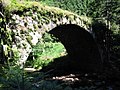
Pont des Fées

Roche du Diable


Economy and Infrastructure
The main line of business is tourism with numerous hotels and pensions. In summer, the Lac de Longemer attracts tourists, in winter it is the ski areas on and on the Vosges ridge. The municipality has a bakery, butcher, grocery store, bookstore, pharmacy, home appliance store, sports shop and several textile stores. A total of 32 retail outlets are located in Xonrupt-Longemer.
The important national road from Colmar over the Col de la Schlucht to Épinal runs through the municipality of Xonrupt-Longemer . From this road (D 417) branches off in Xonrupt-Longemer the road D 8 over the Col de Martimpré to Saint-Dié-des-Vosges . The Vosges ridge road Route des Crêtes also runs through the area of the municipality.
supporting documents
- ↑ Article “Xonville” in: Albert Dauzat , Charles Rostaing : Dictionnaire étymologique des noms de lieu en France . Librairie Guénégaud, Paris, 1979, ISBN 2-85023-076-6 , p. 736b.
- ↑ Auguste Longnon : Les noms de lieu de la France: leur origine, leur signification (= Burt Franklin bibliography and reference series, 487). B. Franklin, New York, 1973, ISBN 0833721429 , p. 243 (reprint of the 1920-1929 edition).
-
^ Ernest Nègre : Toponymie générale de la France . Librairie Droz, Geneva, 2nd edition, 1996, ISBN 2-600-00133-6 , p. 1102.
Article “Rupt” in: Albert Dauzat , Charles Rostaing : Dictionnaire étymologique des noms de lieu en France . Librairie Guénégaud, Paris, 1979, ISBN 2-85023-076-6 . - ^ Albert Dauzat: Le français moderne , Volume 10. JLL d'Artrey, 1942, p. 318: “Au sujet des composés en -ru ( rupt , ruisseau), Xonrupt doit être le ruisseau de la hauteur, summum (cf. le signal du Xon , entre Metz et Nancy). Et Xamontarupt , ( Chamontarus , XIVe s.) Ne représente-t-il pas dans son premier élément, un calmis-mons , formation si répandue? "
- ^ Albert Dauzat, Charles Rostaing: Dictionnaire étymologique des noms de lieu en France.
- ^ History of Xonrupt-Longemer (French)
- ↑ toponym on cassini.ehess.fr
- ↑ Xonrupt-Longemer on cassini.ehess.fr
- ↑ Xonrupt-Longemer on insee.fr
- ↑ Retail stores on annuaire-mairie.fr (French)