Lauret (Hérault)
| Lauret | ||
|---|---|---|

|
|
|
| region | Occitania | |
| Department | Herault | |
| Arrondissement | Lodève | |
| Canton | Lodève | |
| Community association | Grand Pic Saint Loup | |
| Coordinates | 43 ° 50 ' N , 3 ° 53' E | |
| height | 130-408 m | |
| surface | 6.67 km 2 | |
| Residents | 599 (January 1, 2017) | |
| Population density | 90 inhabitants / km 2 | |
| Post Code | 34270 | |
| INSEE code | 34131 | |
| Website | www.commune-lauret.fr | |
 Look at Lauret |
||
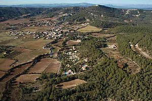
Lauret ( identical in Occitan ) is a French commune with 599 inhabitants (as of January 1, 2017) in the Hérault department in the Occitania region ; it belongs to the Arrondissement of Lodève and the Canton of Lodève (until 2015: Canton Claret ). The inhabitants are called Laurétains .
geography
Lauret is about 24 kilometers north of Montpellier . Lauret is surrounded by the neighboring communities of Claret in the north and west, Sauteyrargues in the east and Valflaunès in the south.
Population development
| Population development | ||||||||
|---|---|---|---|---|---|---|---|---|
| year | 1962 | 1968 | 1975 | 1982 | 1990 | 1999 | 2006 | 2017 |
| Residents | 167 | 166 | 147 | 169 | 224 | 426 | 549 | 599 |
| Sources: Cassini and INSEE | ||||||||
Attractions
- Remnants of the Matane oppidum
Web links
Commons : Lauret - collection of images, videos and audio files
