
Oktyabrsky (Moscow)
| Urban-type settlement
Oktyabrsky
Октябрьский
|
||||||||||||||||||||||||||||||||||||||||||
|
||||||||||||||||||||||||||||||||||||||||||
|
||||||||||||||||||||||||||||||||||||||||||
| List of large settlements in Russia | ||||||||||||||||||||||||||||||||||||||||||
.png)
.png)
.svg)

Oktjabrski ( Russian Октя́брьский ) is an urban-type settlement in the Moscow Oblast ( Russia ) with 13,165 inhabitants (as of October 14, 2010).
geography
The settlement is about 30 km as the crow flies southeast of the center of the Russian capital - also the administrative center of the Oblast - Moscow and about 10 km from the Moscow motorway ring, not far from the right bank of the Pechorka , a left tributary of the Moskva .
Oktyabrsky belongs to Rajon Lyubertsy and is the administrative center of Lyubertsy about 10 km to the southeast. The place forms a municipality of the same name (Gorodskoje posselenije) , to which besides the settlement no other places belong.
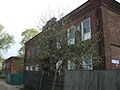
Building from the beginning of the 20th century
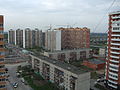
Prefabricated buildings from the 1970s to the present day
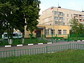
Settlement administration building
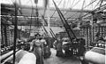
In the Shorygin textile factory before the First World War


history
In place of the current settlement, a village with the name Baljatino was first mentioned in the 16th century . During the reign of Peter I at the beginning of the 18th century, a factory for cutting and stabbing weapons was built there (Russian: Palaschny sawod ). Towards the end of the 19th century, the factory now known as Starogorskaja or Staro-Gorkinskaja manufaktura was converted to textile production ( weaving ) and expanded considerably by the entrepreneur Polijewkt Schorygin by the beginning of the First World War ; during this time it had 2,400 employees. The modern city coat of arms, in which strips of fabric are depicted with riflemen , also point to the town-building company .
In the Soviet period, the factory was after the October Revolution named (imeni Oktjabrskoi Revolyutsii). In 1928 the place received the status of an urban-type settlement, in 1957 its current name, like the textile factory after the October Revolution.
Population development
| year | Residents |
|---|---|
| 1939 | 6.317 |
| 1959 | 7,766 |
| 1970 | 8,437 |
| 1979 | 8,687 |
| 1989 | 8,634 |
| 2002 | 10.135 |
| 2010 | 13,165 |
Note: census data
Attractions
Immediately west of Oktjabrski is the Baulino Forest (Baulinski les), one of the larger forest massifs in the immediate vicinity of the Russian capital.
Economy and Infrastructure
The largest company in town is still the textile factory, now under the name Tekstil-Profi , with an attached shopping center. There is also a furniture factory, a bridge-building company and telecommunications facilities. In recent years, the settlement has increasingly developed into a residential suburb of Moscow.
The M5 trunk road runs through Oktyabrsky and first leads from Moscow to Ryazan and then via Samara to Chelyabinsk . On the section near Moscow it is also referred to as Novorjasanskoje shot ("New Ryazaner Chaussee"). A siding (freight traffic only) connects the town's industrial operations with the Bykowo station six kilometers away on the Moscow - Ryazan railway line.
Personalities
- Vyacheslav Vyacheslavovich Danilin (* 1984), football player
Individual evidence
- ↑ a b Itogi Vserossijskoj perepisi naselenija 2010 goda. Tom 1. Čislennostʹ i razmeščenie naselenija (Results of the All-Russian Census 2010. Volume 1. Number and distribution of the population). Tables 5 , pp. 12-209; 11 , pp. 312–979 (download from the website of the Federal Service for State Statistics of the Russian Federation)