Lyubertsy
| city
Lyubertsy
Люберцы
|
|||||||||||||||||||||||||||||||||||||||||||
|
|||||||||||||||||||||||||||||||||||||||||||
|
|||||||||||||||||||||||||||||||||||||||||||
| List of cities in Russia | |||||||||||||||||||||||||||||||||||||||||||
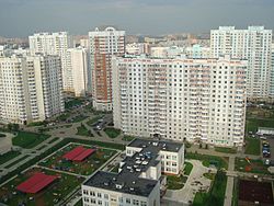
Lyubertsy ( Russian Люберцы ) is a Russian city with 172,525 inhabitants (October 14, 2010) in the Moscow Oblast . It is located around 20 km south-east of Moscow , just before its city limits. Other neighboring cities are Kotelniki and Dzerzhinsky , and the settlements Tomilino and Kraskowo adjoin Lyubertsy .
history
The place was first mentioned in documents from 1621; there Lyuberzy was led as a village called Liberizy , which in turn could be derived from the first name Liber . The village was dominated by agriculture until the 19th century. Over time, the land there changed hands and in the first half of the 18th century belonged to the military and statesman Alexander Menshikov , and later temporarily to the Tsar Peter III .
Lyubertsy experienced a notable development from the late 19th century, when on the one hand the population of Moscow rose sharply and, at the same time, Lyubertsy, which is close to Moscow, was given convenient transport links with the laying of the strategically important railway line Moscow - Ryazan - Kazan . Since then it has developed into a satellite city of Moscow, in which, in addition to numerous summer dates , large residential areas and several industrial companies have sprung up.
Lyubertsy received city status in 1925. In the 1930s, several neighboring villages were also incorporated into Lyubertsy. Towards the end of the 1980s, the city was the center of the Ljubery , an aggressive anti-Western movement.
Population development
| year | Residents |
|---|---|
| 1926 | 10,000 |
| 1939 | 46,491 |
| 1959 | 93,255 |
| 1970 | 139.401 |
| 1979 | 159,563 |
| 1989 | 165.478 |
| 2002 | 156.691 |
| 2010 | 172,525 |
Note: census data (1926 rounded)
economy
Today the city is not so much a dacha suburb, but rather a large industrial city. Among the two dozen industrial objects in Lyubertsy, there are mainly mechanical engineering companies (including a helicopter factory of the Kamow design office and several factories that specialize in the manufacture of agricultural equipment), as well as companies in the wood processing and light and food industries. Agriculture also plays an important role in Lyubertsy, including the large agricultural enterprise Belaya Datscha . A significant number of the city dwellers work in nearby Moscow.
traffic
The city has direct connections to the M 5 trunk road and to the Moscow ring road MKAD , which also has connections to a number of other main roads . In addition, Lyubertsy is a railway junction, as the busy railway line to Arsamas (which is sometimes used as a section of the Trans-Siberian Railway ) branches off from the line to Kazan in the area of the city . There are a total of four passenger stations in the city. The main train station, which serves both routes, is called Lyuberzy-1 . From there, there are regular connections with local trains (also known as Elektrichki ) to Moscow.
sons and daughters of the town

- Mikhail Bychkov (1926–1997), ice hockey player
- Eleonora Vlasowa (1931–1914), ballerina, teacher
- Anatoly Pristavkin (1931–2008), writer and human rights activist
- Viktor Gromakow (1939-2001), bandy player and trainer
- Wladimir Plawunow (* 1949), bandy player and trainer
- Alexander Tenjakow (* 1951), bandy player and trainer
- Alexander Bubnow (* 1955), soccer player and coach
- Sergei Basulew (* 1957), football player
- Vladimir Cholstinin (* 1958), musician, founder of the band Arija
- Igor Voevodin (* 1959), writer, journalist, TV presenter
- Sergei Abelzew (* 1961), politician
- Boris Jakemenko (* 1966), politician, one of the leaders of the Naschi youth organization
- Vasily Jakemenko (* 1971), politician, founder of the youth organizations Iduschtschije wmeste and Naschi
- Pavel Jakowlew (* 1991), football player
In addition, Lyubertsy is the hometown of the famous Russian band Lyube .
Web links
- On the history of the city (Russian)
- Lyubertsy on mojgorod.ru (Russian)
Individual evidence
- ↑ a b Itogi Vserossijskoj perepisi naselenija 2010 goda. Tom 1. Čislennostʹ i razmeščenie naselenija (Results of the All-Russian Census 2010. Volume 1. Number and distribution of the population). Tables 5 , pp. 12-209; 11 , pp. 312–979 (download from the website of the Federal Service for State Statistics of the Russian Federation)


