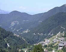
Palai in the Fersental
| Palù del Fersina | ||
|---|---|---|

|
|
|
| Country | Italy | |
| region | Trentino-South Tyrol | |
| province | Trento (TN) | |
| Coordinates | 46 ° 8 ' N , 11 ° 21' E | |
| height | 1360 m slm | |
| surface | 16.7 km² | |
| Residents | 164 (Dec. 31, 2019) | |
| Population density | 10 inhabitants / km² | |
| Post Code | 38050 | |
| prefix | 0461 | |
| ISTAT number | 022133 | |
| Popular name | Paludani | |
| Patron saint | Santa Maria Maddalena | |
| Website | www.comune.paludelfersina.tn.it | |
Palai im Fersental ( Fersentalerisch : Palai / Palae en Bersntol , Italian : Palù del Fersina ) is a municipality ( comune ) with 164 inhabitants (as of December 31, 2019) in the Fersental , Province of Trento , Italy .
The municipal area is divided into two similar areas, Auserpòch (outside the stream) and Inderpòch (inside the stream). The municipality is located in Auserpòch in the Lenzi district at 1360 m above sea level. d. M. The first written evidence of the history of the village dates back to just before 1600, but it is believed that the area was settled in the early 13th century . A special feature of the village is that it is one of the three communities in the eastern Fersental where the majority of the population speaks Fersental German .
Palai borders the following municipalities: Bedollo , Telve , Baselga di Pinè , Telve di Sopra , Sant'Orsola Terme , Florutz ( Vlarötz, Fierozzo ) and Torcegno .
Web links
- Community of Palai on the website of the Fersental Community ( Memento from May 15, 2006 in the Internet Archive )
Individual evidence
- ↑ Statistiche demografiche ISTAT. Monthly population statistics of the Istituto Nazionale di Statistica , as of December 31 of 2019.


