
Vienna Woods
| Vienna Woods | ||
|---|---|---|
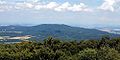
 Vienna Woods near Breitenfurt |
||
| Highest peak | Schöpfl ( 893 m above sea level ) | |
| location | Lower Austria , Vienna | |
| part of | Northern Alps | |
|
||
| Coordinates | 48 ° 5 ' N , 15 ° 55' E | |
| rock | Flysch zone / Kalkalpen ( flysch and Kalkwiener forest ) | |
| surface | 1,056.45 km² | |
| particularities | UNESCO biosphere reserve | |
_-_Leopoldsberg_(3).JPG) Leopoldsberg and Kahlenberg ; northeastern part of the Vienna Woods |
||

The Vienna Woods as the easternmost branch of the Northern Alps is a mountain group in Lower Austria and Vienna and thus forms the northeast end of the Alps . The 45 km long and 20 to 30 km wide low mountain range is largely forested and a popular local recreation area for the Viennese. Today, including the peripheral areas in the metropolis of Vienna itself, it is largely fully designated as a UNESCO Biosphere Park Wienerwald .
physical geography

end of the 19th century. General map of Central Europe , sheet 34 ° 48 ° Vienna. Status: 1893
Location and structure
The hilly to low mountain range, comprising 105,645 hectares , is located in eastern Lower Austria on the border between the Mostviertel (district above the Vienna Woods) and the industrial district (district below the Vienna Woods) , with altitudes between 300 and almost 900 m. From the eastern edge of the mountains you have magnificent views of Vienna and the Vienna Basin .
In the east the Vienna Woods are bounded by the Thermenlinie (tectonic breaks to the Vienna Basin), in the south by the rivers Triesting and Gölsen , in the west by the rivers Traisen and Große Tulln , in the north by the Tullnerfeld and the Danube to the Wiener Pforte and in the Northeast - already in the urban area of Vienna - through the Schwarzenbergpark and the Lainzer Tiergarten .
The valleys of the mountains run mostly east-west and at heights of 200 to 400 m. The change between lonely and densely populated valleys and their strongly varying slope (about 20 to 75%) is particularly attractive . The much- sung Helenental near the spa town of Baden and the striking Hagenbachklamm are particularly impressive .
Geology: Flysch and Kalk-Wienerwald
Geologic the majority part of the Vienna Woods to the Flyschalpen (predominantly sandstone) and is flysh Wienerwald called the southeast contrast to the Limestone ( calcium-Wienerwald ) .
Wiesenwienerwald
The western Wienerwald between Traisen and the Große Tulln is also called the Wiesenwienerwald . In the early Middle Ages, the forest was cleared by the farmers and numerous individual farms with surrounding orchards and only a few places in valleys were formed.
In the numerous orchards and at the forest edges at an altitude of 300 to 500 meters is traditionally Elsbeere cultivated. This region has joined forces and markets the traditional products from the service tree under the Wiesenwienerwald Elsbeere brand . The service tree is also recorded in the register of traditional foods .
Mountains, distant views, passes and caves
.JPG)
The highest elevations in the Vienna Woods are at 893 m above sea level. A. the Schöpfl belonging to the Flysch zone sandstone with the Matraswarte and the neighboring Mitterschöpfl ( 882 m above sea level ), on which the Leopold Figl Observatory of the University of Vienna is located. From the Schöpfl, the view often extends 100 km to Ötscher , Schneeberg and other two-thousand-meter peaks in the Styrian-Lower Austrian Limestone Alps.
Southwest of the Schöpfl is the Gföhlberg at 885 m above sea level. A. , and in the southeast of the Northern Limestone Alps belonging High Lindkogel ( 834 m above sea level. A. ) and the Peilstein ( 716 m above sea level. A. ) with its distinctive climbing wall .
The highest mountain in Vienna's municipal area is the Hermannskogel ( 542 m ) with the Habsburg Tower , which was the fundamental point of the monarchy's surveying network . Also striking is the Dreimarkstein at 454 m , which forms the border between the Vienna districts of Hernals and Döbling and the Lower Austrian town of Weidling . Magnificent views down to Vienna offer the Viennese local mountains Leopoldsberg and Kahlenberg , whose historic churches of the Turkish sieges tell, and the Jubiläumswarte (449/ 480 m ) at the Gallitzinberg and Vienna view in the Lainzer Tiergarten.
In the Vienna Woods there are only a few mountains with a summit cross and a summit book :
- Buchberg 469 m, the second highest mountain in the market town of Maria-Anzbach in the western Vienna Woods
- Steinplattl 649 m , highest elevation in the Wienerwald community in the far northwest on the border with Klausenleopoldsdorf
- Ross summit 633 m , second highest mountain in the Wienerwald community and highest mountain in the cadastral community of Grub . It's west of Grub
- Hoher Ge 540 m , also called Mitterberg, northwest of Weissenbach
- Speicherberg 487 m , Purkersdorf municipality
With the exception of the Hohe Ge, these peaks are not very promising because they are wooded and can only be reached on unmarked paths.
Most of the Vienna Woods are located in the districts of St. Pölten , Mödling and Baden . To connect them with each other, there are some - albeit not high - pass roads such as the Exelberg (Sofienalpe), the Rechtsberg , the Kleiner Semmering , the Hafnerberg , and the Hengstl . There are also some caves, for example the Dreidärrischenhöhle under the Anninger viewing mountain (675/514 m), the Elfen- und Einödhöhle between Pfaffstätten and Gaaden , the Arnsteinhöhle near Maria Raisenmarkt and the stalactite cave Alland . Also worth mentioning is the Seegrotte - the largest underground lake in Europe. Their visit is often combined with some castle ruins near Mödling .
In addition to castles, there are also some important monasteries in the Vienna Woods:
- Heiligenkreuz Abbey on the Via Sacra
- Kleinmariazell Monastery
- Klosterneuburg Abbey
- the Mauerbach Charterhouse
- Lilienfeld is just outside
Some of the other natural sights are worth mentioning: the Glocknergrat and the Lausbubenwand near Mödling, the Matterhörndl, for climbers the Jammerwandl, the Mizzi-Langer-Wand and the overhanging Engelstein near Baden.
Anninger , seen from the Hohen Lindkogel (from the southwest) against the Vienna Basin , Vienna can be seen in the background on the left .

Eastern roofing of the Vienna Woods, Kahlenberg and Döbling , outskirts of the City of Vienna

Peilstein : southern limestone zone of the Vienna Woods

At Alland


List of peaks by Schartenhöhe
| summit | height | Notch height | Reference chart |
|---|---|---|---|
| High Lindkogel | 834 m | 334 m | Dörfl 500 m ( ⊙ ) |
| Schöpfl | 893 m | 312 m | Court mountain 581 m |
| Gföhlberg | 885 m | 290 m | Bruckhof 595 m ( ⊙ ) |
| Anninger | 675 m | 290 m | Smoke meadow 385 m ( ⊙ ) |
| Kukubauerwiese ( ⊙ ) | 782 m | 230 m | Pit farmer 552 m ( ⊙ ) |
| Peilstein | 716 m | 181 m | Schwarzensee 535 m ( ⊙ ) |
| Obelisk (Hadersfeld) ( ⊙ ) | 439 m | 174 m | Roman fountain 265 m ( ⊙ ) |
| Hellstone | 645 m | 175 m | Kühraml 470 m ( ⊙ ) |
| Hermannskogel | 542 m | 172 m | Trench 370 m ( ⊙ ) |
Rivers

The most important rivers in the Vienna Woods are the Wien , Liesing , Sattelbach , Mödlingbach , Schwechat and Triesting , which drain to the east, and the Große Tulln and Kleine Tulln , the Hagenbach and the Weidlingbach , which drain to the north. All of them ultimately flow into the Danube .
climate
The Vienna Woods are essentially determined by the transitional climate , which is shaped by the Atlantic . On the thermal line there is a Pannonian climate , in the mountainous south it is partly alpine . The northern Vienna Woods in particular form a weather divide . Rain clouds coming from the west often rain on the north-western edge. There is also increased fog formation there. Especially on the Vienna outer ring motorway at Hochstraß at an altitude of 553 m, there are often poor traffic conditions due to fog, snow or black ice.
Forest
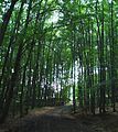
In the north ( Flysch -Wienerwald) the Wienerwald has 77% deciduous forest (mainly beech, oak and hornbeam), in the southeast ( lime- Vienna Forest) about 46% coniferous forest (pine, spruce, black pine , fir and larch); Wine grows on the eastern slopes of the Vienna Woods.
For a long time, the Vienna Woods were a spell forest and royal hunting ground; In the years 1870 to 1872 Josef Schöffel saved a large part of the Vienna Woods from deforestation. Today the Vienna Woods are protected by the laws mentioned above.
The area of the city forest in Vienna is 8,650 ha, that is 20% of the Vienna municipal area (41,487 ha).
Wienerwald at logging

Typical umbrella pine near Mödling (limestone zone)

At the Teufelstein


natural reserve
The Vienna Woods are protected by natural forest reserves, Natura 2000, the Nature Conservation Act and the Landscape Conservation Act and have been a biosphere reserve recognized by UNESCO since 2005 . The Lainzer Tiergarten as part of the Vienna Woods of the federal capital Vienna has been declared a nature reserve. In addition, there are four nature parks that have been set up in parts of the Vienna Woods (from north to south): Oak grove , Sandstone Vienna Forest , Sparbach Nature Park and the Föhrenberge .
A new school and biosphere park center Norbertinum Tullnerbach was built in Tullnerbach by 2013 .
In the year 2014, which was mushroom-rich due to the weather, a census of the mushroom species occurring in the Vienna Woods was carried out. 828 species were found, including 17 species that were previously not native to the Vienna Woods, such as the yellow flaky slime head , the orange-brown Schönkopf or the northern hump bark fungus .
Human geography

history
- See main article: History of the Vienna Woods , History of Lower Austria .
Communities
Important communities in and in the Vienna Woods are Klosterneuburg , St. Andrä-WIERT , Gablitz , Purkersdorf , Mauerbach , Breitenfurt bei Wien , Pressbaum , Eichgraben , Altlengbach , Maria Anzbach , Neulengbach , Alland , Bad Vöslau , Baden , Gumpoldskirchen , Mödling , Brunn am Gebirge , Heiligenkreuz and Wienerwald .
traffic
A number of main traffic routes run through the Vienna Woods: the Westbahn of the ÖBB , the Westautobahn A 1 and the Wiener Außenring Autobahn A 21 (the connecting piece between the West and South Autobahn via Alland ). A construction project that was canceled without replacement was the Wienerwald expressway S 43, which was to form a north-western bypass of Vienna.
Several bus routes operate locally within the framework of the Eastern Region Transport Association .
In order to accelerate the western line in the course of the Vienna Woods, which is an obstacle for express trains, the Vienna Woods Tunnel was under construction under the northern Vienna Woods as part of the New West Line since 2004 . On December 9, 2012, operations on the completed new section Vienna - Sankt Pölten Hauptbahnhof started. On the same day, the Lainzer Tunnel went into operation as a connection to the Südbahn and Ostbahn , which had been under construction since 2006 and is intended to relieve the Vienna Penzing – Wien Meidling railway through the outskirts of Vienna. Since it crosses under the Lainzer Tiergarten , it is popularly known as the wild boar tunnel .
economy


Sand and gravel was and is being mined in numerous places . The former gypsum tunnel of the Seegrotte in Hinterbrühl was used as a factory for fighter planes during the Nazi era. Today the resulting underground lake is a popular excursion destination and show cave . The sea grotto was not the only gypsum mining. Numerous mining sites, one of which was the largest near Preinsfeld near Heiligenkreuz , but also lime mining, led to the construction of furnaces where gypsum and lime were burned.
Various mills such as sawmills, belt mills and forges, some of which are now successful as high-tech companies (e.g. in Berndorf ), were built along the course of the river during the Industrial Revolution . The districts of Mödling and Baden , with more than 6000 active operating locations, are among those with the most in Lower Austria, along with the districts of St. Pölten Stadt and Land. There are slightly fewer companies in the Tulln district and very few in Lilienfeld . In addition to trade, commerce, handicrafts and services, there is a lot of tourism and gastronomy - from mountain huts to haute cuisine . In the Biedermeier city of Baden, the Casinos Austria casino and the health resorts are an important factor. But day and weekend tourism from Vienna also plays a major role.
In terms of agriculture, the foothills of the Alps and the eastern edge of the Alps have relatively unfavorable production conditions due to their altitude (farms up to 1100 m above sea level), steep areas and shallow soils. When there is high rainfall, it is therefore a typical grassland area, only around 20% of the agricultural land is used as arable land (foothills of the Alps and the Vienna Woods with dairy cattle throughout). On the eastern edge of the Alps with less rainfall, mixed farms with a higher proportion of arable land dominate . Here are dairy farms with increasing beef cattle share typical. The cultivation of orchards has recently been gaining in importance again, as must and juice production, but above all cider production in the Triestingtal, has seen a sharp rise in sales. Viticulture is of great importance on the thermal baths line, especially in Gumpoldskirchen , Sooss and Bad Vöslau . Forestry, equestrian sports and organic farming round off the range of services.
Personalities

- Gertrud von Babenberg (1226–1288), titular Duchess of Austria , resided in Alland and gave birth there
- Friedrich I of Baden (1249–1268), titular Duke of Austria
- Poor Schlucker (1748–1820), forest authority builder from Alland
- Josef Schöffel (1832–1910), journalist who saved a large part of the Vienna Woods from being cut down with his articles in 1873
- Simon von Wimpffen (1867–1925), founder of the health spa in Neuhaus
- Wolfgang Ambros (* 1952), important Austrian pop musician from Wolfsgraben
Web links
- Vienna Woods Museum
- Vienna Woods tourist region
- Vienna Woods Biosphere Reserve
- Föhrenberge Nature Park Association, Mödling
- Sandstone Vienna Woods Nature Park, Purkersdorf
Books
- Werner Gamerith (author & photographer): Wienerwald. Natural jewel between city and mountains. Tyrolia Verlag, Vienna 2019, ISBN 978-3-7022-3729-5 .
- Sabine M. Gruber : 111 places in the Vienna Woods that you have to see. Emons Verlag, Cologne 2020, ISBN 978-3-7408-0844-0 .
Individual evidence
- ↑ klima: active in the Wiesenwienerwald. In: Website of the friends of nature. Archived from the original on November 23, 2012 ; accessed on April 4, 2018 .
- ↑ Lower Austria / Wiesenwienerwald-alsbeere . Entry no. Wiesenwienerwald Elsbeere in the register of traditional foods of the Austrian Federal Ministry for Agriculture, Regions and Tourism .
- ^ Statistical data from the City of Vienna's Forestry Office. Archived from the original on April 12, 2016 ; accessed on April 4, 2018 .
- ^ Christian Milota: New School and Biosphere Park Center Tullnerbach. Office of the Lower Austrian State Government, State Office Press Service, February 22, 2008, accessed on August 13, 2019 (NLK press release February 22, 2008).
- ↑ Living in the country. In: home of Lower Austria. of the NÖN edition 12/2014

Allgäu Alps | Ammergau Alps | Bavarian Prealps | Berchtesgaden Alps | Brandenberg Alps | Bregenz Forest Mountains | Chiemgau Alps | Dachstein Mountains | Ennstal Alps | Gutenstein Alps | Hochschwabgruppe | Kaiser Mountains | Karwendel | Lechquellen Mountains | Lechtal Alps | Loferer and Leoganger Steinberge | Mürzsteg Alps | Upper Austrian Pre-Alps | Rax Schneeberg Group | Salzburg Slate Alps | Salzkammergut Mountains | Tennengebirge | Dead Mountains | Türnitz Alps | Wetterstein Mountains and Mieming Range | Vienna Woods | Ybbstal Alps