
Bouxwiller (Haut-Rhin)
| Bouxwiller | ||
|---|---|---|
.svg)
|
|
|
| region | Grand Est | |
| Department | Haut-Rhin | |
| Arrondissement | Altkirch | |
| Canton | Altkirch | |
| Community association | Sundgau | |
| Coordinates | 47 ° 30 ' N , 7 ° 21' E | |
| height | 375-639 m | |
| surface | 6.47 km 2 | |
| Residents | 459 (January 1, 2017) | |
| Population density | 71 inhabitants / km 2 | |
| Post Code | 68480 | |
| INSEE code | 68049 | |

Bouxwiller ( German Buchsweiler ) is a French commune with 459 inhabitants (as of January 1, 2017) in the Haut-Rhin department in the Grand Est region (until 2015 Alsace ). It belongs to the Arrondissement Altkirch , the canton Altkirch and is a member of the Association of Municipalities Sundgau .
geography
The municipality of Bouxwiller is located in the southern Sundgau , about 20 kilometers southeast of Altkirch and 25 kilometers southwest of Basel . The Luppach , a small tributary of the upper Ill, has its source in the municipality of Bouxwillers .
Neighboring communities of Bouxwiller are Durmenach and Werentzhouse in the north, Fislis in the east, Oltingue in the southeast, Raedersdorf and Sondersdorf in the south, Ferrette in the southwest and Vieux-Ferrette in the west.
history
From 1871 until the end of the First World War , Bouxwiller belonged to the German Empire as part of the realm of Alsace-Lorraine and was assigned to the Altkirch district in the Upper Alsace district .
Population development
| year | 1910 | 1962 | 1968 | 1975 | 1982 | 1990 | 1999 | 2006 | 2017 |
|---|---|---|---|---|---|---|---|---|---|
| Residents | 337 | 308 | 330 | 336 | 328 | 314 | 415 | 463 | 459 |
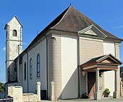
Church of St. James the Elder ( Saint-Jacques-le-Majeur )

town hall
,_%C3%89glise_Saint-Jacques-le-Majeur.jpg)
,_Mairie.jpg)
See also
literature
- Le Patrimoine des Communes du Haut-Rhin. Flohic Editions, Volume 1, Paris 1998, ISBN 2-84234-036-1 , pp. 392-393.
Web links
- Bouxwiller on ccja-jura-alsacien.net (French)