Hedges (Haut-Rhin)
| Hedges | ||
|---|---|---|

|
|
|
| region | Grand Est | |
| Department | Haut-Rhin | |
| Arrondissement | Altkirch | |
| Canton | Masevaux | |
| Community association | Sud Alsace Largue | |
| Coordinates | 47 ° 42 ' N , 7 ° 7' E | |
| height | 293-320 m | |
| surface | 2.45 km 2 | |
| Residents | 497 (January 1, 2017) | |
| Population density | 203 inhabitants / km 2 | |
| Post Code | 68210 | |
| INSEE code | 68125 | |
 Town hall and school building |
||
Hecken is a French commune with 497 inhabitants (as of January 1, 2017) in the Haut-Rhin department in the Grand Est region (until 2015 Alsace ). It belongs to the Arrondissement Altkirch , the canton Masevaux and is a member of the community association Sud Alsace Largue .
geography
The municipality of Hecken is located in the valley of the Largue tributary Soultzbach , about 20 kilometers southwest of Mulhouse near the Burgundian Gate .
Neighboring communities of Hecken are Diefmatten in the north, Gildwiller in the east, Falkwiller in the south, Traubach-le-Haut (point of contact) and Guevenatten in the southwest and Sternenberg in the west.
history
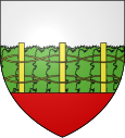
The place name is derived from " Hag " and indicates an enclosed area after clearing the forest . The hedges are also shown on the coat of arms . Hecken was first mentioned in a document as Haegon in 1235 . Before the Peace of Westphalia in 1648, the village belonged to the Vogtei of Traubach and the county of Pfirt .
In 1793 Hecken received in the course of the French Revolution (1789-1799) the status of a municipality and in 1801 the right to local self-government. In 1871 the community was incorporated into the Altkirch district of the newly created Alsace-Lorraine of the German Empire due to changes in territory due to the course of the Franco-German War (1870–1871) . The realm of Alsace-Lorraine existed until the end of the First World War (1914–1918) and was then dissolved. Hecken then belonged back to France.
Population development
| year | 1910 | 1962 | 1968 | 1975 | 1982 | 1990 | 1999 | 2008 | 2017 |
| Residents | 149 | 114 | 120 | 153 | 250 | 372 | 402 | 446 | 497 |
Attractions
The Mairie village school was built in 1842 according to plans by the architect Diogène Poisat from Belfort .
The house of the old watermill dates from the 2nd half of the 18th century. The mill was powered by the Soultzbach. Their performance was estimated at six horsepower in 1855 . In 1899 a steam engine was installed and the mill was converted into a sawmill . In 1900 the mill was damaged by fire and was later rebuilt. The steam engine was dismantled after the First World War.
literature
- Le Patrimoine des Communes du Haut-Rhin. Flohic Editions, Volume 1, Paris 1998, ISBN 2-84234-036-1 , pp. 316-317.
Web links
Individual evidence
- ↑ a b c hedges. (No longer available online.) In: cc-porte-alsace.fr. Communauté de communes de la Porte d'Alsace, archived from the original on August 29, 2014 ; Retrieved September 3, 2011 (French). Info: The archive link was inserted automatically and has not yet been checked. Please check the original and archive link according to the instructions and then remove this notice.
- ^ Ernest Nègre : Toponymie générale de la France . Volume 2: Formations non-romanes, formations dialectales (= Publications romanes et françaises. Vol. 194). 2nd day. Librairie Droz, Geneva 1996, ISBN 2-600-00133-6 , p. 845, online , accessed June 21, 2010, (French).
- ↑ Hedges - notice communal. In: cassini.ehess.fr. Retrieved September 3, 2011 (French).
- ^ Municipal directory Germany 1900 - Altkirch district
- ^ Architecture. In: Base Mérimée. Ministère de la culture, accessed 3 September 2011 (French).
