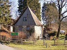
Löhrmühle
|
Löhrmühle
City of Halver
Coordinates: 51 ° 11 ′ 46 ″ N , 7 ° 27 ′ 30 ″ E
|
||
|---|---|---|
| Height : | 337 m above sea level NN | |
| Postal code : | 58553 | |
| Area code : | 02355 | |
|
Location of Löhrmühle in Halver |
||
The Löhrmühle , also called Löher Mühle , is a district of the town of Halver in the Märkisches Kreis ( North Rhine-Westphalia ) and at the same time the oldest surviving watermill on the Ennepe . One of the grinders has been restored and is still operational today.
history
The mill, first mentioned in 1566 (according to other information in 1552), is located in the city of Halver in the Brandenburg region . It was initially called Eichhofer Mühle after the neighboring Fronhof Stieneichhofen , but it was not until 1810 that the current name prevailed.
In 1566, the mill was owned by the St. Gereon Abbey in Cologne , which sold the Fronhof and the mill belonging to it to the noble von Edelkirchen family. Later it was owned by Baron von Holtzbrinck from Altena (later the Rhade House ).
After falling into disrepair at the end of the 18th century, it was rebuilt in 1805.
In 1818 six people lived in the village. In 1838 Löhrmühle belonged to the Eickhöfer peasantry within the Halver mayor . The place called Malmühle und Ackergut according to the locality and distance table of the government district Arnsberg had at that time a house, a factory or mill and two agricultural buildings. At that time, eight people lived in the village, all of whom were Protestant.
The community encyclopedia for the province of Westphalia from 1887 gives a number of five residents who lived in a residential building.
literature
- Karl Rudolf Filling: The Löher Mill. Self-published by the Westfälischer Heimatbund , Münster 1989 ( Technical cultural monuments in Westphalia. 8, ISSN 0930-3944 ).
Individual evidence
- ↑ Johann Georg von Viebahn : Local and distance table of the government district Arnsberg, arranged according to the existing state division, with details of the earlier areas and offices, the parish and school districts and topographical information. Ritter, Arnsberg 1841.
- ↑ Royal Statistical Bureau (Prussia) (ed.): Community encyclopedia for the province of Westphalia, based on the materials of the census of December 1, 1885 and other official sources, (community encyclopedia for the Kingdom of Prussia, Volume X), Berlin 1887.


