
Lagorce (Gironde)
|
Lagorce La Gòrça |
||
|---|---|---|
|
||
| region | Nouvelle-Aquitaine | |
| Department | Gironde | |
| Arrondissement | Libourne | |
| Canton | Le North Libournais | |
| Community association | Libournais | |
| Coordinates | 45 ° 5 ′ N , 0 ° 10 ′ W | |
| height | 5-91 m | |
| surface | 28.47 km 2 | |
| Residents | 1,667 (January 1, 2017) | |
| Population density | 59 inhabitants / km 2 | |
| Post Code | 33230 | |
| INSEE code | 33218 | |
| Website | http://www.lagorce33.fr/ | |
 Town hall (mairie) of Lagorce |
||

Lagorce (in Occitan : La Gorca ) is a southwestern French community with 1,667 inhabitants (as of January 1 2017) in the department of Gironde in the region Nouvelle-Aquitaine . The municipality belongs to the arrondissement of Libourne and the canton of Le Nord-Libournais (until 2015: canton of Guîtres )
location
Lagorce is located about 43 kilometers northeast of Bordeaux on the Lary River . The river Dronne forms the eastern and southeastern municipal boundaries. Lagorce is surrounded by the neighboring communities of Cercoux in the north and north-west, La Clotte in the north, Chamadelle in the east and north-east, Les Peintures in the east, Coutras in the south and south-east, Guîtres in the south and south-west and Bayas in the west and south-west.
Population development
| year | 1962 | 1968 | 1975 | 1982 | 1990 | 1999 | 2006 | 2017 |
| Residents | 947 | 905 | 892 | 1046 | 1238 | 1294 | 1529 | 1667 |
| Sources: Cassini and INSEE | ||||||||
Attractions
- Saint-Pierre church, a historic monument since 1925 , with a 14th century sculpture of the Madonna and Child
- Notre-Dame chapel in Montigaut
See also: List of Monuments historiques in Lagorce (Gironde)
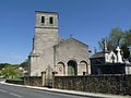
Saint-Pierre church

Notre-Dame chapel in Montigaut


literature
- Le Patrimoine des Communes de la Gironde. Flohic Éditions, Volume 1, Paris 2001, ISBN 2-84234-125-2 , pp. 771-774.