
District of Kempten (Allgäu)
| coat of arms | Germany map | |
|---|---|---|
.png)
|
Coordinates: 47 ° 44 ' N , 10 ° 17' E |
|
| Basic data (as of 1972) | ||
| Existing period: | 1862-1972 | |
| State : | Bavaria | |
| Administrative region : | Swabia | |
| Administrative headquarters : | Kempten (Allgäu) | |
| Area : | 602.3 km 2 | |
| Residents: | 59,400 (Dec. 31, 1971) | |
| Population density : | 99 inhabitants per km 2 | |
| License plate : | KE | |
| Circle key : | 09 7 39 | |
| Circle structure: | 29 municipalities | |
| Address of the district administration: |
8960 Kempten, Germany | |
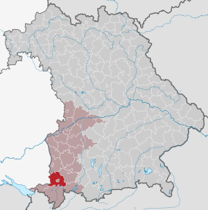
| Location of the district of Kempten (Allgäu) in Bavaria | ||
 _in_Bavaria_1970-05-27.svg) |
||


The district of Kempten (Allgäu) belonged to the Bavarian administrative district of Swabia . Until the beginning of the regional reform in Bavaria at the beginning of the 1970s, the district had 29 municipalities. In today's parlance it is called Altlandkreis Kempten .
geography
The largest places were Altusried , Buchenberg , Durach and Waltenhofen . In 1972 the district bordered clockwise in the north, beginning with the districts of Memmingen , Marktoberdorf , Füssen , Sonthofen and Lindau (Lake Constance) (all in Bavaria ) and the district of Wangen (in Baden-Württemberg ).
history
District Office
The Kempten district office followed the Kempten regional court of the same area in 1862 .
On April 1, 1927, the Kempten district office was expanded to include the communities of Moosbach and Petersthal of the Sonthofen district office .
district
On January 1, 1939, the designation district was introduced as everywhere else in the German Reich . The district office became the Kempten (Allgäu) district.
On July 1, 1972, the district of Kempten (Allgäu) was dissolved as part of the regional reform in Bavaria . The two communities Sankt Lorenz and Sankt Mang were incorporated into the independent city of Kempten (Allgäu) . All other communities were combined with the district of Sonthofen to form the new district of Oberallgäu .
Population development
| year | Residents | source |
|---|---|---|
| 1864 | 22,746 | |
| 1885 | 30,649 | |
| 1900 | 33,353 | |
| 1910 | 37,046 | |
| 1925 | 41,430 | |
| 1939 | 38,422 | |
| 1950 | 55,159 | |
| 1960 | 50,800 | |
| 1971 | 59,400 |
Communities
The municipalities of the Kempten district before the municipal reform. The churches that still exist today are in bold .
| former parish | today's parish | today's district | |
|---|---|---|---|
| 1 | Altusried (market) | Altusried | District of Oberallgäu |
| 2 | Betzigau | Betzigau | District of Oberallgäu |
| 3 | Buchenberg (market) | Buchenberg | District of Oberallgäu |
| 4th | Dietmannsried (market) | Dietmannsried | District of Oberallgäu |
| 5 | Durach | Durach | District of Oberallgäu |
| 6th | Frauenzell | Altusried | District of Oberallgäu |
| 7th | Haldenwang | Haldenwang | District of Oberallgäu |
| 8th | Kimratshofen | Altusried | District of Oberallgäu |
| 9 | Kreuzthal | Buchenberg | District of Oberallgäu |
| 10 | Krugzell | Altusried | District of Oberallgäu |
| 11 | Arbors | Arbors | District of Oberallgäu |
| 12 | Martinszell in the Allgäu | Waltenhofen | District of Oberallgäu |
| 13 | Memholz | Waltenhofen | District of Oberallgäu |
| 14th | Mittelberg | Oy-Mittelberg | District of Oberallgäu |
| 15th | Moosbach | Sulzberg | District of Oberallgäu |
| 16 | Muthmannshofen | Altusried | District of Oberallgäu |
| 17th | Petersthal | Oy-Mittelberg | District of Oberallgäu |
| 18th | Probstried | Dietmannsried | District of Oberallgäu |
| 19th | Reicholzried | Dietmannsried | District of Oberallgäu |
| 20th | Saint Lawrence | Kempten (Allgäu) | 1972 incorporated into the independent city of Kempten (Allgäu) |
| 21st | Santa Mang | Kempten (Allgäu) | 1972 incorporated into the independent city of Kempten (Allgäu) |
| 22nd | Schrattenbach | Dietmannsried | District of Oberallgäu |
| 23 | Sulzberg (market) | Sulzberg | District of Oberallgäu |
| 24 | Überbach | Dietmannsried | District of Oberallgäu |
| 25th | Waltenhofen | Waltenhofen | District of Oberallgäu |
| 26th | Weitnau (market) | Weitnau | District of Oberallgäu |
| 27 | Wengen | Weitnau | District of Oberallgäu |
| 28 | Wiggensbach (market) | Wiggensbach | District of Oberallgäu |
| 29 | Wildpoldsried | Wildpoldsried | District of Oberallgäu |
The community of Rechtis was incorporated into Weitnau on January 1, 1963.
License Plate
On July 1, 1956, the district was assigned the KE distinguishing mark when the vehicle registration number that is still valid today was introduced . It is only issued in the city of Kempten (Allgäu) until today. In the Oberallgäu district it was issued until August 3, 1974.
literature
- Peter Blickle : Historical Atlas of Bavaria. Schwaben, series I., issue 6, 1968.
- Michael Petzet : City and District of Kempten (= Bavarian Art Monuments. Vol. 5, ISSN 0522-5264 ). Deutsche Kunstverlag, Munich 1959.
Individual evidence
- ^ Official register of places for Bavaria 1964
- ^ Wilhelm Volkert (ed.): Handbook of Bavarian offices, communities and courts 1799–1980 . CH Beck, Munich 1983, ISBN 3-406-09669-7 , p. 495 .
- ^ Wilhelm Volkert (ed.): Handbook of Bavarian offices, communities and courts 1799–1980 . CH Beck, Munich 1983, ISBN 3-406-09669-7 , p. 97 .
- ^ Federal Statistical Office (ed.): Historical municipality directory for the Federal Republic of Germany. Name, border and key number changes in municipalities, counties and administrative districts from May 27, 1970 to December 31, 1982 . W. Kohlhammer, Stuttgart / Mainz 1983, ISBN 3-17-003263-1 , p. 777 .
- ^ Ordinance on the reorganization of Bavaria into rural districts and independent cities of December 27, 1971
- ^ Eugen Hartmann: Statistics of the Kingdom of Bavaria . Ed .: Royal Bavarian Statistical Bureau. Munich 1866, population figures of the district offices 1864 ( digitized version ).
- ↑ Royal Bavarian Statistical Bureau (ed.): Localities directory of the Kingdom of Bavaria . Munich 1888, population figures of the district offices 1885 ( digitized ).
- ↑ a b www.gemeindeververzeichnis.de
- ^ Localities directory for the Free State of Bavaria, based on the census of June 16, 1925
- ↑ Statistical Yearbook for the German Reich 1940
- ↑ Statistical Yearbook for the Federal Republic of Germany 1952
- ↑ Statistical Yearbook for the Federal Republic of Germany 1961
- ↑ Statistical Yearbook for the Federal Republic of Germany 1973
- ^ Michael Rademacher: German administrative history from the unification of the empire in 1871 to the reunification in 1990. Landkreis Kempten. (Online material for the dissertation, Osnabrück 2006).
- ↑ BayernViewer of the Bavarian Surveying Administration (accessed on July 7, 2010)
Aichach | Alzenau i.UFr. | Amberg | Bad Aibling | Bad Neustadt adSaale | Bad Toelz | Beilngries | Berchtesgaden | Bow | Brückenau | Burglengenfeld | Dingolfing | Dinkelsbühl | Donauwörth | Ebermannstadt | Boars | Eggenfelden | Erlangen | Eschenbach idOPf. | Feuchtwangen | Friedberg | Feet | Gemünden a.Main | Gerolzhofen | Grafenau | Griesbach i.Rottal | Gunzenhausen | Hammelburg | Hassfurt | Hersbruck | Hilpoltstein | Höchstadt adAisch | Hofheim i.UFr. | Illertissen | Ingolstadt | Karlstadt | Kaufbeuren | Kemnath | Kempten (Allgäu) | Königshofen i.Grabfeld | Kötzting | Krumbach (Swabia) | Landau adIsar | Lauf adPegnitz | Running | Lohr a.Main | Mainburg | Mallersdorf | Marktheidenfeld | Marktoberdorf | Mellrichstadt | Memmingen | Mindelheim | Münchberg | Nabburg | Naila | Neuburg adDonau | Neunburg vorm Wald | Neustadt adAisch | Nordlingen | Nuremberg | Obernburg am Main | Oberviechtach | Ochsenfurt | Parsberg | Pegnitz | Parish churches | Rehau | Riedenburg | Roding | Rothenburg ob der Tauber | Rottenburg adLaaber | Scheinfeld | Schongau | Schrobenhausen | Schwabach | Schwabmünchen | Sonthofen | Stadtsteinach | Staffelstein | Straubing | Sulzbach-Rosenberg | Uffenheim | Viechtach | Vilsbiburg | Vilshofen | Vohenstrauss | Waldmünchen | Wasserburg a.Inn | Wegscheid | Weilheim i.OB | Weißenburg i.Bay. | Wertingen | Wolfratshausen | Wolfstein
1939–1945 affiliated districts: Bergreichenstein | Eisenstein market | Prachatitz