
Mont Cenis colliery
| Mont Cenis colliery | |||
|---|---|---|---|
| General information about the mine | |||
 |
|||
| Mining technology | Underground mining | ||
| Funding / year | 1,082,474 tons (1975) t | ||
| Information about the mining company | |||
| Start of operation | 1871 | ||
| End of operation | 1978 | ||
| Successor use | Academy Mont-Cenis, energy park | ||
| Funded raw materials | |||
| Degradation of | Hard coal | ||
| Greatest depth | 1220 m | ||
| Geographical location | |||
| Coordinates | 51 ° 32 '26.3 " N , 7 ° 15' 23.9" E | ||
|
|||
| Location | Sodingen | ||
| local community | Herne | ||
| Independent city ( NUTS3 ) | Herne | ||
| country | State of North Rhine-Westphalia | ||
| Country | Germany | ||
| District | Ruhr area | ||

The bill Mont Cenis was a coal - mine in Herne - Sodingen . A modern energy park and the new building for the advanced training academy of the state of North Rhine-Westphalia were built on one of its two operating facilities.
history
One year after the sinking of the first shaft Alexandrine in 1871 were the mining concessions to the mining engineer Joseph Pierre Monin from Marseille and the reindeer Franz August Viviers sold from Lyon. In the same year, 1872, the mining union Mont Cenis was founded on July 27th. A year later the coal mountains were reached with the Alexandrine shaft; Nevertheless, coal production did not begin until 1875. Due to the fact that the weather was no longer adequate during further operations , it was necessary to sink a weather shaft associated with shaft 1 in 1884 , which was also equipped with an iron headframe in 1889 .
Four years later, in 1893, the company built its own coal separation and washing facility . In 1897 coal production could be started through shaft 2 Carl , which was started in 1895 and is located approx. 1 km east of shaft 1. A weather shaft assigned to Carl and equipped with a fan connection was completed in 1900 and equipped with a compressor in 1901. The first underground dewatering with compressed air drive on the third level of shaft 1 started operation in 1902. In 1903 the United Bommerbänker Tiefbau colliery in Witten was taken over, but was shut down three years later.
Another shaft started in 1905 was put into operation in 1909. The existing coal washing and separation was also supplemented in 1905 by a coking plant with by-product extraction, the first battery of which went into operation in the same year. A water tower on the Beimberg in the Volkspark Sodingen , which was used to supply the colliery with water , was completed in 1912. The Röchling Group took over the mine in 1917 .
A severe firedamp explosion claimed 85 lives on June 20, 1921.
In 1924, the construction of a connecting railway leading to the port of the Friedrich der Große colliery improved transport connections. In 1927 a high-pressure boiler house including a new power station was built, which was followed a year later by the Glück-Auf-Stadion for SV Sodingen on the colliery site . An additional shaft, shaft 4, was started in 1930.
Other serious mining accidents occurred in 1931 with 19 deaths and in 1935 with 7 deaths.
The Harpen Mining AG took over the mine in 1936, 1939, the union United Constantin the Great , who in 1940 was followed by a Verbindungsbahn Mont Cenis Constantin. The effects of the war forced operations to come to a standstill in 1945; which, however, could gradually be resumed. A fourth coke oven battery went into operation in 1948, in 1958 shaft 4 was sunk up to the 8th level and in 1963 shaft 3 was sunk to the 1,100-meter level; In 1960 a ski lift was installed in shaft 1 . The colliery's coking plant was shut down in 1961.
In 1965, a mine fire claimed nine lives.
After 72 years of operation, shaft 2 was dropped in 1969 and backfilled ; However, one year later, shaft 1 was sunk deeper to the 1,300-meter level. In 1972 the colliery saw the changeover to conveyor belts and the breakdown of a mining mountain to the Friedrich der Große colliery and then, in 1973, the takeover of coal mining by Friedrich der Große .
Both mines, Friedrich der Große and Mont Cenis , were closed in 1978.
location

Location of shaft 1, behind the energy park
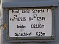
The shaft data of shaft 1

Location of the former shaft 3

The layout of the former shafts 2 and 4


In its largest expansion stage, the colliery consisted of two pits. Plant 1/3 was on Mont-Cenis-Strasse between Kantstrasse and Kirchstrasse, plant 2/4 was about 1 km east of it, northeast of the intersection of Mont-Cenis-Strasse with today's Sodinger Strasse. The 1/3 facility had a siding to the Herne marshalling yard of the Cologne-Mindener Railway, which is now also closed . Both pits were connected to one another by a railroad track. There was also a railway connection to the port of the Friedrich der Große colliery (shaft 3/4) on the Rhine-Herne Canal . This route corresponds to the current course of Sodinger Strasse up to Schadeburgstrasse.
Operational development

On July 27th, 1872 the union of the coal mine Mont-Cenis, Sodingen in Westphalia was founded. The name was given in memory of and out of enthusiasm for a technical masterpiece of that time, the commissioning of the more than 13 km long Mont Cenis tunnel through the massif of the same name in the French Alps on September 17, 1871.
When reaching the coal seams, gas coal was used instead of fatty coal , which had been expected from the neighboring mines because of the findings. This and the numerous geological faults hampered economic development until 1890.
With the sinking of shaft 2 in the east field, the situation improved, since the disturbances there were not so serious. Immediately next to shafts 1 and 2, weather shafts were sunk; they were used to ventilate the mine workings and to discharge the abundant mine gases . At the same time, lively housing construction for the miners began in the immediate vicinity of the pits .
In 1907, by further digging shaft 1, the fourth level could be opened up and thus fat coal could be extracted. This broadened the range of coal types and the first battery of the coking plant could be put into operation.
In 1921 a serious accident occurred when a gunner had illegally blasted dynamite in the coal, causing a firedamp explosion that cost 85 miners the lives. In 1922 the workforce peaked at 5,990. Between 1927 and 1929 more than 1 million tons of coal were mined each year. With the global economic crisis, the number of employees fell to a third.
During the Second World War the production could be kept at approx. 800,000 tons, only in 1945 did it almost come to a standstill. After that, production improved steadily up to a first post-war high of 708,000 tons in 1950.
In 1958 the sales crisis in the German coal industry began. There were the first shifts of the party . In December 1960 was the tailgating a mine fire in East Field the eighth floor. As a result, all activities in the eastern departments were stopped. The reduction in size of the mine field led to increased work in the remaining western departments.
In 1969, the 1,300 meter level was driven ( 1,220 m below sea level ), the deepest main production level in the Ruhr mining industry. From April 1973, the entire coal production from Mont Cenis was transported underground to the Friedrich der Große colliery and brought out in shaft 6. In 1975, Mont Cenis achieved an annual output of 1,082,474 tons and with 4,383 tons the highest average daily output. The underground capacity was 4.912 tons per man and shift.
On March 31, 1978, the Friedrich der Große - Mont Cenis compound system was shut down. The miners were relocated to other Ruhrkohle AG pits, went into adaptation or found jobs in other industries.
Most of the buildings were demolished in 1980 and the remaining shafts were filled in the same year .
Overview of the shafts
| Manhole | Surname | location | sunk | in operation | Out of service | thrown off | status |
|---|---|---|---|---|---|---|---|
| 1 | Alexandrine | 51 ° 32 '26.31 " N , 7 ° 15' 23.91" E | 1871-1875 | 1875 | 1980 | backfilled | |
| Weather shaft 1a | 51 ° 32 '26.56 " N , 7 ° 15' 25.32" E | 1886 | 1946 | backfilled | |||
| 2 | Carl | 51 ° 32 '32.86 " N , 7 ° 16' 1.93" O | 1895 | 1897 | 1966 | 1969 | backfilled |
| Weather shaft 2a | 51 ° 32 '32.08 " N , 7 ° 16' 2.68" E | 1900 | 1946 | backfilled | |||
| 3 | 51 ° 32 ′ 28.43 ″ N , 7 ° 15 ′ 21.64 ″ E , (next to shaft 1) | 1907 | 1980 | backfilled | |||
| 4th | 51 ° 32 ′ 36.5 ″ N , 7 ° 16 ′ 10.4 ″ E , (next to slot 2) | 1931 | 1980 | backfilled | |||
| 5 | 51 ° 32 '50.8 " N , 7 ° 14' 54.4" E | Fragments are still there today. |
![]() Map with all coordinates of the shafts: OSM
Map with all coordinates of the shafts: OSM
In addition, shaft 6 of the Lothringen colliery in Bochum continued to be operated as a weather shaft after it was closed in 1968.
geology
The Mont Cenis colliery deposit is located in a zone with cracks and faults that was not expected when the shafts were sunk. Sloping from south to north, the coal-bearing layers lie under an overburden 170 m in the south and up to 260 m in the north. From west to east there are three large jumps running roughly from northwest to southeast, where the coal-bearing layers are vertically offset by several hundred meters. One can imagine the mountains cut in a V-shape, in which the part enclosed by the V has sunk. In the west is the second jump with a vertical offset of 640 m, in the middle runs the Mont Cenis jump. The Tertius jump runs along the eastern edge of the pit fields, behind which the seams continue 910 m higher.
This means that coal seams have been preserved under the overburden in the collapsed area, which had already been removed outside the collapse before the cover layers were deposited. This results in the variety of types of coal in this deposit. At the top are the younger layers, whose coalification process was not yet so advanced, with gas-rich types of coal . Underneath are the gas-poor coal seams that could be exploited less deeply in the neighboring mines. In this collapse, the individual seams are not straight, but are folded many times, and individual fragments are even pushed over one another like scales. That made coal extraction very difficult. The following types of coal could be mined:
- Gas flame coal: 1 seam;
- Gas coal: 16 seams;
- Fatty coal: 20 seams;
- Edible coal : 5 seams
Kaiser Wilhelm Tower (water tower)


The Kaiser Wilhelm Tower was built in 1912/1913 on the Beimberg, just above the pit 2/4. The site was acquired by the Sodingen Office in 1910 in order to set up a park on the wooded hill, which was called Kaiser Wilhelm Park from 1913 and Volkspark from 1919.
![]()
When the Mont Cenis colliery wanted to use the hill to erect an iron water tower, the building for the elevated tank was combined with an observation tower at the suggestion of the Sodingen bailiff. The office contributed financially to the establishment. The tower was designed by the architect and director of the Essen School of Crafts and Applied Arts, Alfred Fischer .
The tower was inaugurated as part of a folk festival for the 25th anniversary of the eponymous monarch in July 1913.
The reinforced concrete tower is 31.5 m high and contained two water tanks of 350 and 80 m³ for supplying the shafts. In the 1930s it was no longer needed for this, it remained its function as a lookout tower. From the windows of the octagonal, copper-covered dome you have a good view of the Herne district of Sodingen, Recklinghausen , Castrop-Rauxel and the Emschertal . Since January 2016, the tower itself has also been part of the route of industrial culture in theme route 28 - Water: Works, Towers and Turbines .
Views from the tower
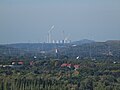
View to the northwest: on the left the Hoppenbruch heap , in the middle the power plants in Scholven and on the right the Hohewardhalde

in the north the chemical plants of Rütgers , the Lambertus Church in Henrichenburg , behind it the Datteln power station

in the northeast parts of Castrop , the Knepper power plant in Dortmund and the power plants on the Datteln-Hamm Canal

St. in the east Castrop with Lambertus Church, the Lutheran Church and the shaft structure of Erin , cut top right: Erin bay 3


Mont-Cenis Academy
The building, planned in partnership between the German architecture firm HHS Planer + Architekten AG and the French architecture firm Jourda & Perraudin (Francoise Helene Jourda and Gilles Perraudin), is enclosed by a glass climate envelope that creates a Mediterranean climate similar to that in Nice . This is on average 5 ° C warmer than the outside temperature. Computer-controlled ventilation enables heat to be exchanged without the need for additional energy . Water features, underground channels and large gates prevent overheating in summer.

In addition, the solar system (see the Energy Park section ), which is currently the largest building-integrated system of its kind, is installed in a cloud shape that varies in density, which also leads to shading (and explains the colored effects when looking at an aerial photo). In addition, white, adjustable window sills reflect incident daylight into the actual building.
Inside the building made of glass and 56 spruce trunks, the offices of the city administration, a district library, a café, a multi-purpose room (citizens' hall) and the advanced training academy of the state of North Rhine-Westphalia with hotel rooms are located in small groups of buildings . Water features, palm trees and bridges over pools emphasize the Mediterranean character.
Mont Cenis is conceived as a so-called production cluster that combines an industrial park , green spaces and the construction of new residential buildings.
Energy park
After the closure at the end of the 1980s , the government of North Rhine-Westphalia decided to build the energy park on the site of shafts 1/3. This should be used commercially; the city of Herne took the initiative and announced a competition. The idea for the energy park came from the German architecture firm HHS Planer + Architekten AG under Manfred Hegger , which ultimately won the competition and built the park.
The Energy Park represents the power and heat for the entire site and neighboring buildings using methane - gas and solar energy forth. The surpluses are fed into the local grid. The Mont-Cenis energy park consists of three large modules:
- Solar power plant: Electricity generation through polycrystalline solar cells on the roof and in the walls of the academy
- Combined heat and power plant: generation of electricity and heat by burning captured, otherwise escaping mine gas
- Battery storage system: storage of solar power, peak load reduction, emergency power supply
With an area of 10,000 m², the solar system on the roof of the Mont-Cenis Academy is currently the largest building-integrated solar power plant in the world. The 3185 modules generate up to 1 MW of power or 750,000 kWh per year. The block-type thermal power station generates around 9,000 MWh of electricity per year. The heat generated by the combined heat and power unit is used to heat the buildings within the microclimate envelope (academy, hotel, library, etc.), the hospital and the new (residential) buildings in the immediate vicinity (local heating network) created in the course of the project. Stadtwerke Herne is the operator of the energy park.
- Mont-Cenis Academy

View into the academy building - the solar cells in the roof

Academy: construction made of wood and glass

Under the glass roof in a Mediterranean climate there are various public facilities such as a library, civic hall and a cafe

Field of stelae by Herman Prigann north of the building

Sunset with reflections on the glass facade on the south-west front

Inside and outside continue seamlessly and are only separated from each other by glass


literature
- Francoise-Helene Jourda, Manfred Hegger : Mont-Cenis. Lively architecture. Müller and Busmann, Wuppertal 2003, ISBN 3-928766-48-1 .
- Joachim Huske : The coal mines in the Ruhr area. Data and facts from the beginnings to 1997. Bochum 1998, ISBN 3-921533-62-7 .
- Wolfgang Viehweger: Trace of Coal: Europe in Herne and Wanne-Eickel. Frischtexte Verlag, Herne 2000, ISBN 978-3-933059-03-1
Individual evidence
- ^ A b Petra Helling: Advanced training academy in Herne . In: IBA Emscherpark (= Bauwelt ). tape 29 , 1999, ISSN 0931-6590 , p. 1608-1613 .
- ^ Mont-Cenis development company: Mont-Cenis. Herne Training Academy. District center Herne-Sodingen. 1 megawatt solar power plant of the municipal utility. Herne 1998 (brochure)
- ^ Development company Mont-Cenis: ... on Mont-Cenis. Back then (collection of brochures, no year)
- ↑ Manfred Hildebrandt [edit.]: Herne - from Ackerstraße to Zur-Nieden-Straße: City history in the mirror of street names . Ed .: Stadt Herne, Der Oberbürgermeister (= Publications of the City Archives Herne . Volume 1 ). Herne 1997 (entry: Am Volkspark ).
- ↑ a b Jörn-Hanno Hendrich: Alfred Fischer-Essen: 1881–1950; an architect for industry . University library Rheinisch-Westfälische Technische Hochschule Aachen, Aachen 2012, DNB 1022617729 .
- ↑ a b c The data come from the board at the foot of the tower to station 18 of the wasser) xkurs herne , Stadt Herne, 2002.
- ^ A b Development company Mont-Cenis: ... on Mont-Cenis. The architecture (brochure collection no year)
- ↑ http://www.ruhrgebiet-industriekultur.de/mont-cenis.html (private website - accessed on October 7, 2010; update unknown)
- ^ Development company Mont-Cenis: ... on Mont-Cenis. The energy park (collection of brochures, no year)
- ↑ Building management Herne: Archived copy ( memento of the original from June 16, 2004 in the Internet Archive ) Info: The archive link was inserted automatically and has not yet been checked. Please check the original and archive link according to the instructions and then remove this notice. (Architecture / Energy Park - accessed on October 8, 2010; update unknown)
Web links
- Description of all locations on this themed route as part of the Route of Industrial Culture
- Herner Zechen: Zeche Mont Cenis at herne.de (last accessed on November 13, 2012)
- Vocational College Herne: Mont Cenis (last accessed on November 13, 2012)
- Website of the Mont-Cenis Academy
- Early documents and newspaper articles on the Mont Cenis colliery in the 20th century press kit of the ZBW - Leibniz Information Center for Economics .
Visitor center and anchor points (from west to east): Museum of German Inland Shipping | Inner harbor Duisburg | LVR Industrial Museum Oberhausen | Landscape Park Duisburg-Nord | Gasometer Oberhausen | Aquarius Water Museum | St. Antony Hut | Villa Huegel | Nordsternpark | Zeche Zollverein World Heritage Site and Zollverein Coking Plant | Ewald colliery | Marl Chemical Park | Railway Museum Bochum-Dahlhausen | Henrichshütte | Centennial Hall Bochum | Recklinghausen substation | German Mining Museum | Nightingale colliery | Henrichenburg ship lift | DASA | Hansa coking plant | Zeche Zollern II / IV | Hohenhof | Hagen Open Air Museum | Lindenbrauerei Unna | Maximilian Park Hamm
Themed routes (in ascending order by number): 1. Duisburg: City and Harbor | 2. Industrial cultural landscape Zollverein | 3. Duisburg: industrial culture on the Rhine | 4. Oberhausen: Industry makes the city | 5. Krupp and the city of Essen | 6. Dortmund: triad coal, steel and beer | 7. Industrial culture on the Lippe | 8. Erzbahn-Emscherbruch | 9. Industrial culture at Volme and Ennepe | 10. Brine, steam and coal | 11. Early industrialization | 12. The past and present of the Ruhr | 13. On the way to the blue Emscher | 14. Canals and shipping | 15. Lanes in the area | 16. Westphalian mining route | 17. Rhenish mining route | 18. Chemistry, Glass and Energy | 19. Workers' settlements | 20. Entrepreneur villas | 21. Bread, grain and beer | 22. Myth of the Ruhr Area | 23. Parks and Gardens | 24. Industrial nature | 25. Panoramas and Landmarks | 26. Sacred buildings | 27. Iron & Steel | 28. Water: works, towers and turbines | 29. Bochum - industrial culture in the heart of the district | 30. Gelsenkirchen | 31. Industrial Culture and Bauhaus Route | by bike
Marl Chemical Park ![]() |
Ruhr Oel GmbH |
Phenol chemistry |
Sachtleben Chemie |
Grillo-Werke AG |
Momentive / Rütgers |
Ruhrchemie |
Gasometer Oberhausen | Zollverein World Heritage Site - Zollverein XII Colliery and Zollverein Coking Plant |
gaseum - the world of gas |
Prosper coking plant |
Ruetgers |
Hansa coking plant |
Hoesch Gasometer |
Evonic / Cremer Oleo |
Otto Schott - memorial in the Witten town hall |
Solvay |
Pumped storage power plant Koepchenwerk |
Herdecke energy industry hiking trail |
Hohenstein hydropower plant |
Knepper power plant |
Gersteinwerk power plant |
Recklinghausen substation |
Lünen power plant |
Solar power plant Academy Mont Cenis |
Herne power plant |
Solar bunker Gelsenkirchen |
Hoppenbruch heap |
Baldeney hydropower plant |
Kahlenberg hydropower plant |
Raffelberg hydropower plant |
Walsum power plant |
Voerde power plant
|
Ruhr Oel GmbH |
Phenol chemistry |
Sachtleben Chemie |
Grillo-Werke AG |
Momentive / Rütgers |
Ruhrchemie |
Gasometer Oberhausen | Zollverein World Heritage Site - Zollverein XII Colliery and Zollverein Coking Plant |
gaseum - the world of gas |
Prosper coking plant |
Ruetgers |
Hansa coking plant |
Hoesch Gasometer |
Evonic / Cremer Oleo |
Otto Schott - memorial in the Witten town hall |
Solvay |
Pumped storage power plant Koepchenwerk |
Herdecke energy industry hiking trail |
Hohenstein hydropower plant |
Knepper power plant |
Gersteinwerk power plant |
Recklinghausen substation |
Lünen power plant |
Solar power plant Academy Mont Cenis |
Herne power plant |
Solar bunker Gelsenkirchen |
Hoppenbruch heap |
Baldeney hydropower plant |
Kahlenberg hydropower plant |
Raffelberg hydropower plant |
Walsum power plant |
Voerde power plant![]()
![]()
![]()
![]()
![]()

Old waterworks Wesel |
Bockum waterworks |
Duisburg-Mündelheim waterworks |
Mülheim Styrum / Ost waterworks |
Mülheim-Dohne waterworks |
Essen-Kettwig waterworks |
Wolfsbachtal Essen Waterworks |
Bochum-Stiepel waterworks |
Verbund waterworks Witten |
Dorsten-Holsterhausen waterworks |
Haltern Waterworks |
Rohrmeisterei Schwerte |
Vinner water tower |
Water tower Wesel |
Rheinhausen-Bergheim water tower |
Water tower of the Lower Rhine gas and water works |
Aquarius Water Museum ![]() |
RWW Headquarters |
Mülheim-Fulerum water tower |
Water tower Essen-Condition |
Water tower Steeler Berg |
Essen-Steele water tower |
Essen-Byfang water tower |
Essen-Bredeney water tower |
Water tower Frillendorfer Höhe |
Water room Bochum-Stiepel |
Water tower Bochum-Weitmar |
Herten double water towers |
Water towers on Hellweg |
Water tower Lanstroper egg |
Bommerholz water tower |
Volmarstein-Loh water tower |
Hagen-Hohenlimburg water tower |
Blue water tower Ahlen | Water tower of the Pattberg colliery | Double cooling plant in the Duisburg-Nord landscape park
|
RWW Headquarters |
Mülheim-Fulerum water tower |
Water tower Essen-Condition |
Water tower Steeler Berg |
Essen-Steele water tower |
Essen-Byfang water tower |
Essen-Bredeney water tower |
Water tower Frillendorfer Höhe |
Water room Bochum-Stiepel |
Water tower Bochum-Weitmar |
Herten double water towers |
Water towers on Hellweg |
Water tower Lanstroper egg |
Bommerholz water tower |
Volmarstein-Loh water tower |
Hagen-Hohenlimburg water tower |
Blue water tower Ahlen | Water tower of the Pattberg colliery | Double cooling plant in the Duisburg-Nord landscape park ![]() | Cooling towers of the Zeche Zollverein XII
| Cooling towers of the Zeche Zollverein XII ![]() |
RWW water tower |
Kaiser Wilhelm Tower | Water storage at the Jahrhunderthalle Bochum
|
RWW water tower |
Kaiser Wilhelm Tower | Water storage at the Jahrhunderthalle Bochum ![]() |
Water tower from Luhn & Pulvermacher / Dittmann & Neuhaus | Elevated water tank of the Henrichshütte
|
Water tower from Luhn & Pulvermacher / Dittmann & Neuhaus | Elevated water tank of the Henrichshütte ![]() | Cooling towers of the Hansa coking plant
| Cooling towers of the Hansa coking plant ![]() |
Rheinhausen-Friemersheim water tower | Water towers Railway depot and marshalling yard Duisburg-Wedau |
Hochfeld water tower | Water tower at Oberhausen main station |
Roundhouse and Camera Obscura | Water tower in the Bochum Railway Museum |
Water tower Dortmund Südbahnhof | Water tower at Dortmund depot |
Heilenbeck dam |
Ennepetalsperre |
Glörtalsperre |
Hasper dam |
Kahlenberg return pumping station |
Emscher estuary sewage treatment plant |
Alte Emscher pumping station |
Schwelgern pumping station |
Schmidthorst pumping station |
Emscher sewage park |
Läppkes Mühlenbach |
BernePark |
Bottrop sewage treatment plant |
Gelsenkirchen-Horst pumping station |
Emscherbruch |
Nettebach pumping station |
Dortmund-Deusen sewage treatment plant |
Emscherpumpwerk Huckarde |
Evinger Bach pumping station |
Emscher Bridge Lindberghstrasse |
Kaßlerfeld sewage treatment plant |
Historic sewage treatment plant Essen-Rellinghausen |
Run-of-river power plant Kahlenberg |
Raffelberg hydropower plant |
Baldeney hydropower plant |
Hohenstein hydropower plant |
Harkort power plant |
Pumped storage power plant Koepchenwerk |
Schwitten run-of-river power plant |
Wickede run-of-river power plant |
Friedrichsbad Schwelm |
Kurpark Königsborn |
Kurpark Hamm |
Raffelberg saltwater pool |
Museum of German Inland Shipping
|
Rheinhausen-Friemersheim water tower | Water towers Railway depot and marshalling yard Duisburg-Wedau |
Hochfeld water tower | Water tower at Oberhausen main station |
Roundhouse and Camera Obscura | Water tower in the Bochum Railway Museum |
Water tower Dortmund Südbahnhof | Water tower at Dortmund depot |
Heilenbeck dam |
Ennepetalsperre |
Glörtalsperre |
Hasper dam |
Kahlenberg return pumping station |
Emscher estuary sewage treatment plant |
Alte Emscher pumping station |
Schwelgern pumping station |
Schmidthorst pumping station |
Emscher sewage park |
Läppkes Mühlenbach |
BernePark |
Bottrop sewage treatment plant |
Gelsenkirchen-Horst pumping station |
Emscherbruch |
Nettebach pumping station |
Dortmund-Deusen sewage treatment plant |
Emscherpumpwerk Huckarde |
Evinger Bach pumping station |
Emscher Bridge Lindberghstrasse |
Kaßlerfeld sewage treatment plant |
Historic sewage treatment plant Essen-Rellinghausen |
Run-of-river power plant Kahlenberg |
Raffelberg hydropower plant |
Baldeney hydropower plant |
Hohenstein hydropower plant |
Harkort power plant |
Pumped storage power plant Koepchenwerk |
Schwitten run-of-river power plant |
Wickede run-of-river power plant |
Friedrichsbad Schwelm |
Kurpark Königsborn |
Kurpark Hamm |
Raffelberg saltwater pool |
Museum of German Inland Shipping ![]() |
Ebertbad |
Friedrichsbad Essen |
Leisure center Haus Wittringen |
Parkbad South |
Volkspark outdoor pool |
Ruhrnatur House
|
Ebertbad |
Friedrichsbad Essen |
Leisure center Haus Wittringen |
Parkbad South |
Volkspark outdoor pool |
Ruhrnatur House