
Montagny-près-Louhans
| Montagny-près-Louhans | ||
|---|---|---|
|
||
| region | Bourgogne-Franche-Comté | |
| Department | Saône-et-Loire | |
| Arrondissement | Louhans | |
| Canton | Louhans | |
| Community association | Bresse Louhannaise Intercom ' | |
| Coordinates | 46 ° 40 ′ N , 5 ° 16 ′ E | |
| height | 178-208 m | |
| surface | 9.51 km 2 | |
| Residents | 454 (January 1, 2017) | |
| Population density | 48 inhabitants / km 2 | |
| Post Code | 71500 | |
| INSEE code | 71303 | |

Montagny-pres-Louhans is a French commune in the department of Saone-et-Loire in the region of Bourgogne Franche-Comté . It belongs to the Louhans arrondissement and the Louhans canton of the same name . The place has 454 inhabitants (as of January 1, 2017). The inhabitants are Montagnons , respectively. Called Montagnonnes .
geography
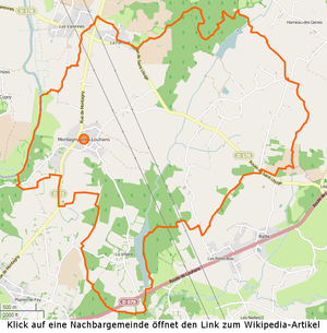

Montagny-près-Louhans is located in the Bresse countryside , 4.4 kilometers northeast of the canton capital Louhans , on a hill above the Seille River . This forms part of the western border with Saint-Usuge , together with the Ruisseau de Bunay in the northern part. The Ruisseau de l'Étang du Villard , which also serves as a letter for the Étang du Villard , forms part of the southeastern border . There are two large forest areas and three étangs in the municipality . In the far south of the commune, the D678 departmental road touches the communal area without touching any populated areas. The following hamlets and corridors belong to the municipality: Bas-de-Montagny, Champ-Billard, Champ-Joly, Chênes-Cornus, Cours, Ferrière, Feys, Marsots, Putacrot, Rippe-Pageault, Verdin, Vessières, Vesvre, Villard .
climate
The climate in Montagny-près-Louhans is warm and temperate. There is significant rainfall throughout the year, even the driest month still has high rainfall. The effective climate classification according to Köppen and Geiger is Cfb . The annual average temperature is 11.0 ° C. Spread over a year, the rainfall adds up to 834 mm.
| Montagny-près-Louhans | ||||||||||||||||||||||||||||||||||||||||||||||||
|---|---|---|---|---|---|---|---|---|---|---|---|---|---|---|---|---|---|---|---|---|---|---|---|---|---|---|---|---|---|---|---|---|---|---|---|---|---|---|---|---|---|---|---|---|---|---|---|---|
| Climate diagram | ||||||||||||||||||||||||||||||||||||||||||||||||
| ||||||||||||||||||||||||||||||||||||||||||||||||
Toponymy
The main settlement of Montagny-près-Louhans probably only emerged with the construction of the church or was previously insignificant. The name can indicate an owner named Montaniacus - but it can also go back to a corruption of Montagne (German: mountain).
history
A first mention of places in the municipality refers to the hamlet Putacrot and goes back to 1374. The hamlet is located just under two kilometers east of the present-day settlement of Montagny, its name indicates a well or pond with bad water, is also called Put for the first time a Crot mentioned ( put old French: bad, spoiled, crot old French: depression, hollow). The next mention relates to Le Villard in connection with a Pierre Verney du Villart from 1476. It is located in the south near Departementsstrasse 978. This designation indicates a settlement in the Gallo-Roman period , Villaria as a small settlement near the old connecting road Louhans - Lons-le-Saunier and located on the banks of the Étang of the same name. The place seems to have been sparsely populated, Courtépée mentions only 12 fires in 1490 , i.e. households in the municipality of Montagny, and parts of it belonged to other present-day municipalities, such as Ferrière , which belonged to Saint-Usuge. In the 18th century the Thoisy and Beaurepaire families were alternately lords of Montagny. The church is dedicated to Saint Étienne and was built in 1837. In 1856 there were still two mills in operation and in 1988 there were still 26 farms.
population
| year | 1793 | 1800 | 1821 | 1831 | 1836 | 1841 | 1851 | 1861 | 1872 | 1881 | 1891 | 1901 | 1911 | 1921 | 1931 | 1946 | 1962 | 1975 | 1982 | 1990 | 1999 | 2006 | 2010 |
|---|---|---|---|---|---|---|---|---|---|---|---|---|---|---|---|---|---|---|---|---|---|---|---|
| Residents | 550 | 542 | 647 | 702 | 703 | 651 | 622 | 576 | 630 | 619 | 601 | 578 | 610 | 531 | 474 | 490 | 394 | 328 | 342 | 364 | 372 | 432 | 480 |


Economy and Infrastructure
In addition to the Mairie and the church, Montagny-près-Louhans owns eight farms, two of which are breeders of Bresse chickens , six construction companies, three forestry companies and a catering company. As AOC products are in Le Fay de Bresse Volaille and Dinde de Bresse , further Crème et beurre de Bresse admitted.
Educational institutions
There is an École élémentaire in the municipality , which is subordinate to the Académie de Dijon and attended by 22 children. The vacation schedule for zone A applies to the school.
literature
- Claude Courtépée (1721–1781): Description historique et topographique du Duché de Bourgogne . tape 5 . Chez Causse, Dijon 1780 (French, Google Books ).
- Lucien Guillemaut (1842-1917): Histoire de la Bresse Louhannaise. Vol. 1, Louhans 1897.
- Lucien Guillemaut (1842–1917): Armoiries et familles nobles de la Bresse louhannaise: armoiries ouvrières, armoiries particulières et de familles . Vve L. Romand, Louhans 1909 (French, gallica ).
Web links
- Montagny-près-Louhans. on INSEE. Institut national de la statistique et des études économiques , accessed on January 18, 2015 (French).
- Montagny-près-Louhans. in the register of communes in France. Retrieved January 18, 2015 (French).
- Montagny-près-Louhans. in the Base Mérimée . Ministère de la Culture, accessed January 18, 2015 (French).
- Montagny-près-Louhans. in Archives départementales. Saône-et-Loire department, accessed on January 21, 2016 (French).
Individual evidence
- ^ Montagny-près-Louhans. on habitants.fr. Retrieved January 24, 2016 (French).
- ↑ La Seille , length 100.0 km, tributary to the Saône , source at 46 ° 45 ′ 52.2 ″ N , 5 ° 41 ′ 30.8 ″ E in Ladoye-sur-Seille at approx. 390 m, mouth at 46 ° 31 ′ 10.6 ″ N , 4 ° 56 ′ 20.8 ″ E in La Truchère at approx. 169 m, La Seille on sandre.eaufrance.fr
- ↑ Ruisseau de Bunay , length 2.4 km, tributary to Seille , source at 46 ° 40 ′ 41.2 ″ N , 5 ° 17 ′ 5.3 ″ E in Saint-Usuge at approx. 197 m, mouth at 46 ° 39 '47.5 " N , 5 ° 15' 41" O in Saint-Usuge m to about 178, Ruisseau de Bunay on sandre.eaufrance.fr
- ↑ Ruisseau de l'Étang du Villard , length 6.8 km, tributary to Ruisseau de Blaine, source at 46 ° 40 ′ 38.3 ″ N , 5 ° 18 ′ 22.7 ″ E in Le Fay at approx. 198 m , Mouth at 46 ° 37 ′ 44 ″ N , 5 ° 16 ′ 35 ″ E in Louhans at approx. 184 m, Ruisseau de l'Étang du Villard on sandre.eaufrance.fr
- ^ Department road D678. on routes.wiki.com. Retrieved November 29, 2015 (French).
- ↑ Dictionnaire Topographique de Saône-et-Loire. (PDF) Comité des Travaux Historiques et Scientifiques, accessed on April 16, 2015 (French, search term: Ctrl+ FMontagny-près-Louhans).
- ↑ Brief description of the church. (PDF) by Montagny-près-Louhans. La Pastorale du Tourisme en Saône et Loire, accessed on May 30, 2015 (French).
- ↑ Population statistics on cassini.ehess.fr. Retrieved November 29, 2014 (French).
- ^ Chicken de Bresse. to INAO, L'Institut national de l'origine et de la qualité. Retrieved June 26, 2015 (French).
- ↑ Dinde de Bresse. to INAO, L'Institut national de l'origine et de la qualité. Retrieved June 26, 2015 (French).
- ↑ Crème de Bresse. to INAO L'Institut national de l'origine et de la qualité. Retrieved July 3, 2015 (French).
- ↑ Beurre de Bresse. to INAO L'Institut national de l'origine et de la qualité. Retrieved July 3, 2015 (French).
- ^ Homepage of the Académie de Dijon. Retrieved January 10, 2016 (French).
- ↑ Vacation and holiday schedule for Zone A. Montagny-près-Louhans. Retrieved January 10, 2016 (French).