
Saint-Usuge
| Saint-Usuge | ||
|---|---|---|
.png)
|
|
|
| region | Bourgogne-Franche-Comté | |
| Department | Saône-et-Loire | |
| Arrondissement | Louhans | |
| Canton | Louhans | |
| Community association | Bresse Louhannaise Intercom ' | |
| Coordinates | 46 ° 41 ′ N , 5 ° 15 ′ E | |
| height | 177-210 m | |
| surface | 31.84 km 2 | |
| Residents | 1,345 (January 1, 2017) | |
| Population density | 42 inhabitants / km 2 | |
| Post Code | 71500 | |
| INSEE code | 71484 | |
| Website | http://saint-usuge.fr/ | |

Saint-Usuge is a French commune in the department of Saone-et-Loire in the region of Bourgogne Franche-Comté . It belongs to the Louhans arrondissement and the Louhans canton of the same name . The place has 1345 inhabitants (as of January 1, 2017). The inhabitants are Saint-Eusebiens , resp. Saint-Eusèbiennes called and are nicknamed Les Tapons (German: crumpled piece of cloth in the form of a cone, cloth plug), which goes back to a brawl in 1834 between the Saint-Eusèbiens and the residents of the neighboring communities.
geography
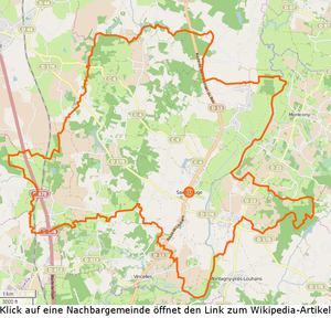

Saint-Usuge is located roughly in the center of the Louhans arrondissement, around 6 km north-northeast of Louhans . The department road D13 from Saint-Germain-du-Bois to Louhans runs through the municipality in a north-south direction. The municipality includes several étangs with the associated biefs and is touched by six rivers . The most important is probably the Seille , which forms the municipality boundary in the northeast and southeast. The Ruisseau de Bunay , together with the Bief de l'Étang de Balole, also forms part of the southeastern municipal boundary . The south-western boundary of the municipality is La Servonne , into which the Ruisseau de Promby and the Ruisseau de Chaintre flow . The Guyotte rises in the far north of the municipality and flows north into the Doubs. The watershed between Doubs and Seille runs through the northern municipality . The western municipal area is generally quite wooded. The following hamlets and corridors belong to the municipality: Barand, Batard, Biolet, Bons-Sires, Boux, Breuve, Canière, Carruge, Champ-des-Mares, Champ-Gauthey, Chanée, Charangeroux, Chizes, Cugny, Curtil, Burtil-Berthod, Curtil-Louis, Devant, Ferrière, Granges, Guillemin-Bernard, Juifs, Long-le-Bief, Maisons-Neuves, Martin-du-Bas, Michauds, Montceau, Moulin-de-Romain, Petite-Tremaillère, Pierry, Plaine- Vesvre, Pomière, Port, Rippes, Roire, Thiellet, Tremaillère, Tucelle, Tuilerie, Varennes, Vauvril, Vesvre, Vicheresse, Villermin.
climate
The climate in Saint-Usuge is warm and temperate. There is significant rainfall throughout the year, even the driest month still has high rainfall. The effective climate classification according to Köppen and Geiger is Cfb . The annual average temperature is 11.1 ° C. Spread over a year, the rainfall adds up to 819 mm.
| Saint-Usuge | ||||||||||||||||||||||||||||||||||||||||||||||||
|---|---|---|---|---|---|---|---|---|---|---|---|---|---|---|---|---|---|---|---|---|---|---|---|---|---|---|---|---|---|---|---|---|---|---|---|---|---|---|---|---|---|---|---|---|---|---|---|---|
| Climate diagram | ||||||||||||||||||||||||||||||||||||||||||||||||
| ||||||||||||||||||||||||||||||||||||||||||||||||
Toponymy
The place appears for the first time in 1155 as Ecclesia Sancti-Eusebii (German: Church of Saint Eusebius). The lords of Montcony founded a chapel dedicated to Saint Eusebius of Vercelli . The place name developed from the name of the saint via Saint Eusèbe sur Seille , Saint-Euruges to the current form.
history
Until 1710, the parish of Saint-Usuge included today's parishes of Saint-Usuge, Montcony and Vincelles . During the French Revolution the place was called Chalon sur Seille . The Roman road from Louhans to Bellevesvre ran through Saint-Usuge. In Charangeroux , two moths are visible close together , one rectangular and one round. The current church building dates from the 14th century and consists of the typical brick walls with a bell tower in the style of Franche-Comté . Various fiefs existed in what is now the municipality , in 1461 Barand came into the possession of Jaques Bouton and remained in the family's possession until 1556. Charangeroux was owned by the de Tholongeon family , in 1593 it came into the possession of Herard Bouton von Chamilly , in whose family it remained until the beginning of the 18th century. In the 18th century there was a brickworks in Saint-Usuge , the municipality was the canton capital from 1790 to 1802. In 1856 there were three grain and oil mills on the Seille , in 1860 the Départementstraße RD 13 was built. At the beginning of the 20th century there were brick factories in Thiollet and Barand , while blacksmiths, clog makers and wine merchants were active in the town center. In 1988 there were still 89 farms in the municipality. The hamlets of Barand , Ferrière and Varennes are located on the east side of the Seille and were famous for their grain of excellent quality. The farmers drove up to 20 kilometers to get ash to dry and fertilize their soil.
heraldry
Saint-Usuge uses a coat of arms that evidently originated in modern times. In field 1 there is a red-tongued dog's head, probably as a reference to the dog breed Epagneul de Saint-Usuge , in field 2 a silver church tower, as it is typical for Franche-Comté and also adorns the church of the community. Fields 3 and 4 fill elements as they appear in the coat of arms of the Bourgogne-Franche-Comté region , both in terms of the fields and the border. It is remarkable, however, that not the entire coat of arms was integrated, but only the lower part of the Burgundy coat of arms in the lower part of the municipal coat of arms .
Culture and sights
- Church of Saint Eusebius of Vercelli (origins 14th century, parts from 16th and 18th centuries)
- Epagneul de Saint-Usuge , the pointing dog from Bresse
population
| year | 1793 | 1800 | 1821 | 1831 | 1841 | 1851 | 1861 | 1872 | 1881 | 1891 | 1901 | 1911 | 1921 | 1931 | 1946 | 1962 | 1975 | 1990 | 1999 | 2006 | 2011 | |||||||||||||||||||||||||||||||||||||||||||||||||||||||||||||||||||||||||||||||||||||||||||||||||||||||||||||||||||||||||||||||||||||||||||||||||||||||||||||||||||||||||||||||||||||||||||||||||||||||||||||||||||||||||||||||||||||||||||||||||||||||||||||||||||||||||||||||||||||||||||||||||||||||||||||||||||||||||||||||||||||||||||||||||||||||||||||||||||||||||||||||||||||||||||||||||||||||||||||||||||||||||||||||||||||||||||||||||||||||||||||||||||||||||||||||||||||||||||||||
|---|---|---|---|---|---|---|---|---|---|---|---|---|---|---|---|---|---|---|---|---|---|---|---|---|---|---|---|---|---|---|---|---|---|---|---|---|---|---|---|---|---|---|---|---|---|---|---|---|---|---|---|---|---|---|---|---|---|---|---|---|---|---|---|---|---|---|---|---|---|---|---|---|---|---|---|---|---|---|---|---|---|---|---|---|---|---|---|---|---|---|---|---|---|---|---|---|---|---|---|---|---|---|---|---|---|---|---|---|---|---|---|---|---|---|---|---|---|---|---|---|---|---|---|---|---|---|---|---|---|---|---|---|---|---|---|---|---|---|---|---|---|---|---|---|---|---|---|---|---|---|---|---|---|---|---|---|---|---|---|---|---|---|---|---|---|---|---|---|---|---|---|---|---|---|---|---|---|---|---|---|---|---|---|---|---|---|---|---|---|---|---|---|---|---|---|---|---|---|---|---|---|---|---|---|---|---|---|---|---|---|---|---|---|---|---|---|---|---|---|---|---|---|---|---|---|---|---|---|---|---|---|---|---|---|---|---|---|---|---|---|---|---|---|---|---|---|---|---|---|---|---|---|---|---|---|---|---|---|---|---|---|---|---|---|---|---|---|---|---|---|---|---|---|---|---|---|---|---|---|---|---|---|---|---|---|---|---|---|---|---|---|---|---|---|---|---|---|---|---|---|---|---|---|---|---|---|---|---|---|---|---|---|---|---|---|---|---|---|---|---|---|---|---|---|---|---|---|---|---|---|---|---|---|---|---|---|---|---|---|---|---|---|---|---|---|---|---|---|---|---|---|---|---|---|---|---|---|---|---|---|---|---|---|---|---|---|---|---|---|---|---|---|---|---|---|---|---|---|---|---|---|---|---|---|---|---|---|---|---|---|---|---|---|---|---|---|---|---|---|---|---|---|---|---|---|---|---|---|---|---|---|---|---|---|---|---|---|---|---|---|---|---|---|---|---|---|---|---|---|---|---|---|---|---|---|---|---|---|---|---|---|---|---|---|---|---|---|---|---|---|---|---|---|---|---|---|---|---|---|---|---|---|---|---|---|---|---|---|---|---|---|---|---|---|---|---|---|---|---|---|---|---|---|---|---|---|---|---|---|---|---|---|---|---|---|---|---|---|---|---|
| Residents | 2,400 | 2.159 | 2,370 | 2,473 | 2,420 | 2,442 | 2,269 | 2,280 | 2,320 | 2,236 | 2,189 | 2,188 | 2.008 | 1,900 | 1,794 | 1,561 | 1,223 | 1.105 | 1,052 | 1,081 | 1,230 | |||||||||||||||||||||||||||||||||||||||||||||||||||||||||||||||||||||||||||||||||||||||||||||||||||||||||||||||||||||||||||||||||||||||||||||||||||||||||||||||||||||||||||||||||||||||||||||||||||||||||||||||||||||||||||||||||||||||||||||||||||||||||||||||||||||||||||||||||||||||||||||||||||||||||||||||||||||||||||||||||||||||||||||||||||||||||||||||||||||||||||||||||||||||||||||||||||||||||||||||||||||||||||||||||||||||||||||||||||||||||||||||||||||||||||||||||||||||||||||||
| From 1962 official figures excluding residents with a second residence | ||||||||||||||||||||||||||||||||||||||||||||||||||||||||||||||||||||||||||||||||||||||||||||||||||||||||||||||||||||||||||||||||||||||||||||||||||||||||||||||||||||||||||||||||||||||||||||||||||||||||||||||||||||||||||||||||||||||||||||||||||||||||||||||||||||||||||||||||||||||||||||||||||||||||||||||||||||||||||||||||||||||||||||||||||||||||||||||||||||||||||||||||||||||||||||||||||||||||||||||||||||||||||||||||||||||||||||||||||||||||||||||||||||||||||||||||||||||||||||||||||||||||||||||||||||


Economy and Infrastructure
In addition to the Mairie and the church, there are 19 farms, a bakery, a butcher's, four retail outlets in various sectors, a restaurant and 12 construction companies in the community. As AOC products are in Saint-Usuge de Bresse Volaille and Dinde de Bresse , further Crème et beurre de Bresse admitted.
Educational institutions
There is an École primaire ( École maternelle and École élémentaire ) in the municipality , which is subordinate to the Académie de Dijon and attended by 108 children. The vacation schedule for zone A applies to the school.
literature
- Claude Courtépée (1721–1781): Description historique et topographique du Duché de Bourgogne . tape 5 . Chez Causse, Dijon 1780 (French, Google Books ).
- Lucien Guillemaut (1842-1917): Histoire de la Bresse Louhannaise. Vol. 1, Louhans 1897.
- Lucien Guillemaut (1842–1917): Armoiries et familles nobles de la Bresse louhannaise: armoiries ouvrières, armoiries particulières et de familles . Vve L. Romand, Louhans 1909 (French, gallica ).
Web links
- Saint-Usuge. on INSEE. Institut national de la statistique et des études économiques , accessed on January 18, 2015 (French).
- Saint-Usuge. in the register of communes in France. Retrieved January 18, 2015 (French).
- Saint-Usuge. in the Base Mérimée . Ministère de la Culture, accessed January 18, 2015 (French).
- Saint-Usuge. in Archives départementales. Saône-et-Loire department, accessed on January 21, 2016 (French).
Individual evidence
- ↑ Saint-Usuge. on habitants.fr. Retrieved January 24, 2016 (French).
- ↑ Tapons in Wiktionary , french retrieved November 29, 2014
- ^ Department road D13. on routes.wiki.com. Retrieved December 2, 2015 (French).
- ↑ La Seille , length 100.0 km, tributary to the Saône , source at 46 ° 45 ′ 52.2 ″ N , 5 ° 41 ′ 30.8 ″ E in Ladoye-sur-Seille at approx. 390 m, mouth at 46 ° 31 ′ 10.6 ″ N , 4 ° 56 ′ 20.8 ″ E in La Truchère at approx. 169 m, La Seille on sandre.eaufrance.fr
- ↑ Ruisseau de Bunay , length 2.4 km, tributary to Seille , source at 46 ° 40 ′ 41.2 ″ N , 5 ° 17 ′ 5.3 ″ E in Saint-Usuge at approx. 197 m, mouth at 46 ° 39 '47.5 " N , 5 ° 15' 41" O m in Saint-Usuge to about 178, Ruisseau de Bunay on sandre.eaufrance.fr
- ↑ Bief de l'Étang de Balole , length 2.2 km, tributary to Seille , source at 46 ° 42 ′ 38.9 ″ N , 5 ° 15 ′ 45.7 ″ E in Saint-Germain-du-Bois on approx m. 200, mouth at ' "16.2 46 ° 42 N , 5 ° 17' 2.4" O m in Saint-Usuge to about 180, Bief de l'Étang de Balole on sandre.eaufrance.fr
- ↑ La Servonne , length 14.8 km, tributary to the Seille , source at 46 ° 42 ′ 46.4 ″ N , 5 ° 9 ′ 44.6 ″ E in Simard at approx. 210 m, mouth at 46 ° 39 ′ 14 , 4 " N , 5 ° 13 '26.4" O in Louhans m to about 178, La Servonne on sandre.eaufrance.fr
- ↑ Ruisseau de Promby , length 4.6 km, tributary to the Servonne , source at 46 ° 43 ′ 3.7 ″ N , 5 ° 11 ′ 42.7 ″ E in Simard at approx. 207 m, mouth at 46 ° 40 ′ 50.5 " N , 5 ° 11 '42" O m in Saint-Usuge to about 186, Ruisseau de Promby on sandre.eaufrance.fr
- ↑ Ruisseau de Chaintre , length 7.2 km, tributary to the Servonne , source at 46 ° 43 ′ 3.4 ″ N , 5 ° 12 ′ 37.8 ″ E in Simard at approx. 204 m, mouth at 46 ° 39 ′ 47.2 ″ N , 5 ° 13 ′ 56.3 ″ E in Vincelles (Saône-et-Loire) at approx. 178 m, Ruisseau de Chaintre on sandre.eaufrance.fr
- ↑ La Guyotte , length 41.1 km, tributary to the Doubs , source at 46 ° 43 ′ 7 ″ N , 5 ° 14 ′ 26.9 ″ E in Saint-Usuge at approx. 205 m, mouth at 46 ° 56 ′ 25.1 ″ N , 5 ° 8 ′ 26.9 ″ E in Navilly at approx. 175 m, La Guyotte on sandre.eaufrance.fr
- ↑ Dictionnaire Topographique de Saône-et-Loire. (PDF) Comité des Travaux Historiques et Scientifiques, accessed on April 16, 2015 (French, search term: <CTRL> -f Saint-Usuge).
- ^ Armorial des villes et des villages de France. Saint-Usuge. Retrieved February 9, 2016 (French, original glazing : Coupé par une trangle ondée d'azur de deux pièces, l'une voûtée à dextre, l'autre ployée à senestre: au 1er parti au I d'azur à une tête de chien d'or languée de gueules, au II d'or à un clocher franc-comtois d'argent, ouvert et essoré d'azur et mouvant de la pointe, le tout enfermé dans une filière de gueules, à un filet de même brochant sur la ligne de parti; au 2e parti au I bandé d'or et d'azur, au II d'azur à trois fleurs de lys d'or, le tout enfermé dans une filière partie de gueules et componée de gueules et d'argent , à un filet de gueules brochant sur la ligne du parti ).
- ↑ Brief description of the church. (PDF) by Saint-Usuge. La Pastorale du Tourisme en Saône et Loire, accessed on May 30, 2015 (French).
- ↑ Population statistics on cassini.ehess.fr. Retrieved November 29, 2014 (French).
- ^ Chicken de Bresse. to INAO, L'Institut national de l'origine et de la qualité. Retrieved June 26, 2015 (French).
- ↑ Dinde de Bresse. to INAO, L'Institut national de l'origine et de la qualité. Retrieved June 26, 2015 (French).
- ↑ Crème de Bresse. to INAO L'Institut national de l'origine et de la qualité. Retrieved July 3, 2015 (French).
- ↑ Beurre de Bresse. to INAO L'Institut national de l'origine et de la qualité. Retrieved July 3, 2015 (French).
- ^ Homepage of the Académie de Dijon. Retrieved January 10, 2016 (French).
- ↑ Vacation and holiday schedule for Zone A. Saint-Usuge. Retrieved January 10, 2016 (French).