
Saint-Christophe (Tarn)
|
Saint-Christophe Sant Cristofòl |
||
|---|---|---|
|
||
| region | Occitania | |
| Department | Camouflage | |
| Arrondissement | Albi | |
| Canton | Carmaux-2 Vallée du Cérou | |
| Community association | Carmausine Ségala | |
| Coordinates | 44 ° 9 ' N , 2 ° 3' E | |
| height | 156-484 m | |
| surface | 14.47 km 2 | |
| Residents | 125 (January 1, 2017) | |
| Population density | 9 inhabitants / km 2 | |
| Post Code | 81190 | |
| INSEE code | 81245 | |
 Town hall (Mairie) of Saint-Christophe |
||

Saint-Christophe ( Occitan Sant Cristofòl ) is a French commune with 125 inhabitants (as of January 1, 2017) in the Tarn department in the Occitania region (before 2016 Midi-Pyrénées ). It belongs to the arrondissement of Albi and the canton of Carmaux-2 Vallée du Cérou .
geography

Saint-Christophe is located around 30 kilometers north-northwest of Albi . Saint-Christophe is surrounded by the neighboring communities of Saint-André-de-Najac in the north, Montirat in the east, Le Ségur in the south and south-east, Laparrouquial in the south and Saint-Martin-Laguépie in the west and south-west.
Population development
| year | 1962 | 1968 | 1975 | 1982 | 1990 | 1999 | 2006 | 2013 |
| Residents | 196 | 169 | 165 | 133 | 107 | 123 | 126 | 135 |
| Source: Cassini and INSEE | ||||||||
Attractions
- Saint-Christophe Church
- Narthaux Church
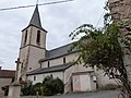
Saint-Christophe Church

Narthoux Church


Web links
Commons : Saint-Christophe - Collection of images, videos and audio files