
Saint-Clément (Meurthe-et-Moselle)
| Saint-Clément | ||
|---|---|---|

|
|
|
| region | Grand Est | |
| Department | Meurthe-et-Moselle | |
| Arrondissement | Luneville | |
| Canton | Baccarat | |
| Community association | Territoire de Lunéville à Baccarat | |
| Coordinates | 48 ° 32 ' N , 6 ° 36' E | |
| height | 234-324 m | |
| surface | 16.47 km 2 | |
| Residents | 861 (January 1, 2017) | |
| Population density | 52 inhabitants / km 2 | |
| Post Code | 54950 | |
| INSEE code | 54472 | |
 St. Clement's Church |
||

Saint-Clément is a French commune with 861 inhabitants (as of January 1, 2017) in the Meurthe-et-Moselle department in the Grand Est region . It belongs to the Arrondissement Lunéville and the municipal association Territoire de Lunéville à Baccarat .
geography
The municipality of Saint-Clément is located on the Meurthe , about ten kilometers southeast of Lunéville in the south of the Meurthe-et-Moselle department.
The 16.47 km² large community area is characterized on the one hand by the wide Meurthetal, which is used intensively for agriculture. The second large natural area is the Forêt de Mondon , which is part of a 30 km² contiguous forest area. The forest area is on average 50 meters above the Meurthetal and separates it from the Vezouze valley .
Neighboring municipalities of Saint-Clément are: Laronxe , Moncel-lès-Lunéville , Thiébauménil and Bénaménil in the north, Buriville in the east, Chenevières and Flin in the southeast, Vathiménil in the south and Fraimbois in the northwest. From 1818 to 1834 the territory of the commune of Laronxe i was part of Saint-Clément.
history
Originally the village was called Sériménil which consisted of a few houses and a church. After the discovery of a spring dedicated to Saint Clement , a martyr from the 1st century, the place was renamed after the saint. In the Middle Ages, after the outbreak of the plague, the place fell into desolation for several years. Parts of the subsequently rebuilt church in Saint-Clément from the 12th century are still preserved today.
In 1757 clay deposits were discovered in Saint-Clément. As in the neighboring town of Lunéville (Lünstadt) a year earlier, Jacques Kammer also built an earthenware factory in Saint-Clément in 1758 , which became famous for its faience and is still in operation today.
Population development
| year | 1962 | 1968 | 1975 | 1982 | 1990 | 1999 | 2007 | 2017 | |
| Residents | 757 | 806 | 779 | 897 | 876 | 833 | 876 | 861 | |
| Sources: Cassini and INSEE | |||||||||
Attractions
- St. Clemens Church , first mentioned in 1164
Economy and Infrastructure
There are seven farms in the community (grain cultivation, dairy farming, beekeeping, goat and sheep breeding). Some of the inhabitants of Saint-Clément live from small craft businesses or work in the local earthenware manufacture. An important economic factor is the location of the 53rd Telecommunications Regiment ( 53e Régiment de Transmissions ) in the nearby Lasalle military camp ; civilian workers from Saint-Clément and the surrounding area also work here.

Mairie Saint-Clément

Town center with the sign to the military area

Earthenware manufacture

Faience from the Saint-Clémenter / Lunéviller manufactory
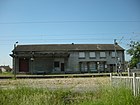
old station building at the Saint-Clément-Laronxe stop


Transport links
Until the completion of the bypass at the beginning of 2009, the national road 59 from Lunéville via Saint-Dié-des-Vosges to Sélestat in Alsace led through Saint-Clément . Another road connects Saint-Clément with the municipality of Thiébauménil on the Vezouze River . Saint-Clément-Laronxe train station is on the Nancy- Saint-Dié-des-Vosges line, operated by TER Lorraine .
supporting documents
- ↑ toponym on cassini.ehess.fr
- ^ History of the community ( Memento from September 5, 2013 in the Internet Archive ) (French)
- ↑ Saint-Clément on cassini.ehess.fr
- ↑ Saint-Clément on insee.fr
- ↑ Farms on annuaire-mairie.fr (French)