Saint-Nazaire
|
Saint-Nazaire Sant-Nazer |
||
|---|---|---|

|
|
|
| region | Pays de la Loire | |
| Department | Loire-Atlantique | |
| Arrondissement | Saint-Nazaire | |
| Canton | Main town of Saint-Nazaire-1 Saint-Nazaire-2 |
|
| Community association | Region Nazairienne et l'Estuaire | |
| Coordinates | 47 ° 17 ′ N , 2 ° 13 ′ W | |
| height | 0-47 m | |
| surface | 46.79 km 2 | |
| Residents | 69,993 (January 1, 2017) | |
| Population density | 1,496 inhabitants / km 2 | |
| Post Code | 44600 | |
| INSEE code | 44184 | |
| Website | www.mairie-saintnazaire.fr | |
 Saint-Nazaire |
||
Saint-Nazaire ( Breton : Sant-Nazer ) is a municipality and port city with 69,993 inhabitants (as of January 1, 2017) on the Loire estuary in France . It belongs to the department of Loire-Atlantique in the Region Pays de la Loire and is the seat of a sub-prefecture . The place name can be traced back to St. Nazarius .
location
The city is located 50 km from Nantes on the northern bank of the mouth of the Loire into the Atlantic Ocean . With the Pointe de Chémoulin , the most south-westerly point of the municipality forms the border between the river mouth and the sea. Immediately north of the city is the La Brière regional nature park .
Neighboring municipalities are Pornichet , La Baule-Escoublac , Saint-André-des-Eaux , Saint-Joachim , Trignac and Montoir-de-Bretagne, and on the other side of the Loire estuary, Saint-Brevin-les-Pins .
history
1800-1940

At the beginning of the 19th century, Saint-Nazaire was still an insignificant coastal town with a small port. Many residents worked as pilots and guided ships through the Loire estuary. With increasing size, these could no longer call at the upstream port of Nantes, especially since the Loire increasingly silted up. In 1856 , a first port basin was built near Saint-Nazaire for the large sailing ships that brought raw materials from Chile , Australia or New Caledonia . In 1857 the railway from Nantes reached the place. In 1861 the Compagnie Générale Transatlantique (CGT or "Transat") was founded, whose ships headed for destinations in Central America from Saint-Nazaire from 1862 onwards . Saint-Nazaire quickly became the second most important Atlantic port in France after Le Havre . In 1881, the Bassin de Penhoët, the largest port basin in Europe, was inaugurated, as well as three huge dry docks .
The state obliged the Transat to have at least half of its ships built in the country. The latter turned to the Scottish company John Scott & Co, which built a shipyard in Saint-Nazaire . In 1864 the first of numerous following passenger ships with an iron hull was launched there . In 1881 the shipyard became a subsidiary of Transat as Chantiers et Ateliers de Penhouët . In 1879 a steelworks (Forges de Trignac) was built in nearby Trignac .
In 1860 Saint-Nazaire still had 800 inhabitants, in 1900 there were already 30,000. The immigrants came primarily from the nearby marshes Brière and the departments of Morbihan and Finistère . The peak of the activity was during the First World War , when the port of Saint-Nazaire was the most important transit port for soldiers and material of the United States Army .
After the withdrawal of the US troops, the place got into its first crisis. In order to compensate for the resulting decline, the shipyards began building aircraft and thus opened up a new industrial perspective for the city. The Great Depression of 1929 brought the next turning point: Overseas passenger traffic increasingly turned to Le Havre, the Trignac ironworks was closed, and social unrest paralyzed the city. In 1932 the Forme Joubert dock lock was completed.
Second World War
During the German occupation in World War II , the Navy built a submarine bunker in Saint-Nazaire . The dry dock "Forme Joubert" was 350 m long and 50 m wide enough to accommodate the German battleships of the Bismarck class . At the end of March 1942 the dock was made unusable by the British commando Operation Chariot . After the Allied invasion , Saint-Nazaire was converted into a fortress under General Hans Junck by the 265th Infantry Division . The Western Allies refrained from taking the city by force because the conquest of Brest - whose port had also been converted into a fortress - was only possible with enormous losses on both sides and only resulted in an unusable, destroyed port. The German occupation surrendered on May 11, 1945, three days after the end of the war in Europe .
Since 1944
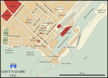
When the Americans liberated it, 80 percent of Saint-Nazaire was destroyed. Until 1960, under the direction of the architect Noël Le Maresquier, the reconstruction was carried out according to a modern plan. If it was originally oriented towards the sea, it now turns its back on it. The main axis was the newly constructed, approx. 1.4 km long Avenue de la République in a north-south direction. The rectangular structure of the new streets largely corresponded to that of the 19th century.
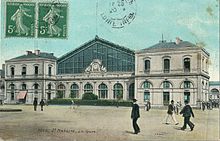
The old terminal station , which was near the Transat quay , was replaced in 1955 by a through station in the north of the city. Its former reception building has served as a theater since 2012 . In 1975 the Pont de Saint-Nazaire road bridge was opened to traffic. The 3356 m long structure is part of the D 213 department road and the only Loire bridge west of Nantes.
coat of arms
Description: In blue a single-masted silver sailing boat with a black key in a billowing silver square sail floating on a silver corrugated shield base and in the silver shield head with five black ermines a golden key with a beard cut into a cross and a four - pass bridle pointing to the right .
economy

The seaport is the fourth largest in France and the largest French port on the Bay of Biscay . Large passenger ships were built at the Chantiers de l'Atlantique shipyard , such as the Normandie (1935), the France (1962) and the Queen Mary 2, which was completed in 2003 . In May 2013 the Europa 2 was completed by the shipbuilding group STX France Cruise SA.
There are refineries near the city . Aerolia St. Nazaire is a supplier for several aircraft manufacturers, u. a. for the local Airbus plant with 2300 employees who assemble the cockpit (section 11) of the Airbus A380 . This is further preinstalled there together with the lower center fuselage section (section 15; wing center box ) and the front sections 13-14 prefabricated in the Hamburg-Finkenwerder plant . The sections are then brought from the port of St. Nazaire first by ship and later by land to Toulouse , where they are assembled with the other sections to form the finished aircraft. In addition, the front parts of the A318 to A321 families as well as A330 and A340 will be further equipped, which will then be delivered with the Airbus Beluga (A300-600ST) and later brought to the Hamburg-Finkenwerder and Toulouse locations.
Saint-Nazaire is the headquarters of the defense company ACMAT .
The offshore wind farm Banc de Guérande is to be built off Saint-Nazaire by 2022 .
traffic

The Pont de Saint-Nazaire is a cable-stayed bridge near the shipyards, which is around 3.3 km long and spans the Loire estuary and connects the town with the municipality of Saint-Brevin-les-Pins .
Saint-Nazaire can be reached from Paris by TGV via the Tours – Saint-Nazaire railway ; The train station is also the starting point for the route to Le Croisic .
Attractions
- The former submarine bunker of the German Navy
- The lock Forme Joubert , 1942 The aim of the British commando company St Nazaire Raid
- The fortified and covered lock for submarines opposite the submarine bunker, where the decommissioned French submarine Espadon is now kept in a museum
- Écomusée de Saint-Nazaire, museum dedicated to the history of the city on avenue de Saint-Hubert
- Escal'Atlantic, an exhibition on the passenger ships built in Saint-Nazaire in the former submarine bunker
Flora and fauna
The associated coast is the Côte d'Amour, on which the famous seaside resorts of La Baule and Pornichet are also located. The salt marshes on the Guérande peninsula between the sea and the La Brière moor extend over an area of around 1,800 hectares in a landscape of silt, tributaries and shallow evaporation basins . La Brière is a living cultural monument of 40,000 hectares, which has been a nature reserve since 1970 and has been the backdrop for numerous films. The Brière Regional Nature Park ( French Parc naturel régional de Brière ) comprises 18 municipalities, including Saint-Nazaire. In its willow and reed-covered expanses of peat bog, wet meadows and canals, there is an extraordinary fauna.
tourism
The Route Bleue (Blue Route) runs through Saint-Nazaire and has eleven important prehistoric megalithic monuments . Including the Tumulus of Dissignac (1) near the city and "des Mousseaux " (9) west of Pornic . Among the dolmens : Croix de Sandun (3), la Joselière (10), des Rossignols (6), du Prédaire (11), du Riholo (5) and Kerbourg (4) are the numbers 9-11 on the Pays de Rets especially known at Pornic. Then there are the menhirs of Bissin (2), la Pierre Attelée (8), Pierre de Couche (7),
Town twinning
-
 Saarlouis , Germany
-
 Avilés , Spain
-
 Saint-Hubert , Canada
-
 Sunderland , UK
-
 Kribi , Cameroon
Personalities
- Odette du Puigaudeau (1894–1991), writer and explorer
- Yann Goulet (1914–1999), Breton nationalist and sculptor
- Jean Dotto (1928-2000), racing cyclist
- Gustave Tiffoche (1930–2011), painter, potter and sculptor
- Pierre-Yves Rochon (* 1946), interior designer
- Hervé Gaschignard (* 1959), Roman Catholic theologian and bishop
- Patrice Halgand (* 1974), racing cyclist
- Frédéric Chiffoleau (* 1975), jazz musician
- Tony Heurtebis (* 1975), soccer player
- Bryan Coquard (* 1992), racing cyclist
literature
- Le Patrimoine des Communes de la Loire-Atlantique . Flohic Editions, Volume 2, Charenton-le-Pont 1999, ISBN 2-84234-040-X , pp. 1141-1175.
Web links
- City of Saint-Nazaire website (French)
- Tourism in Saint-Nazaire
- History of the city of Saint-Nazaire (French)
Individual evidence
- ↑ a b c d Noël Brloëlec: The Bretagne . Parkland, Stuttgart 1988, ISBN 3-88059-294-2 , p. 104 .
- ↑ a b c d Saint-Nazaire at terresceltes.net, accessed on February 19, 2020


