
World Heritage cultural landscape of the Upper Middle Rhine Valley
| Upper Middle Rhine Valley | |
|---|---|
|
UNESCO world heritage |
|

|
|
| Logo of the UNESCO World Heritage Upper Middle Rhine Valley |
|
| National territory: |
|
| Type: | Culture |
| Criteria : | (ii) (iv) (v) |
| Reference No .: | 1066 |
| UNESCO region : | Europe and North America |
| History of enrollment | |
| Enrollment: | 2002 (session 26) |


The World Heritage cultural landscape of the Upper Middle Rhine Valley refers to a cultural landscape on the Middle Rhine which was added to the UNESCO World Heritage List on June 27, 2002 . The World Heritage area extends from Bingen / Rüdesheim to Koblenz over a length of 67 km along the valley of the Rhine through the Rhenish Slate Mountains .
The uniqueness of this cultural landscape is the extraordinary wealth of cultural evidence. The Middle Rhine Valley owes its special appearance on the one hand to the natural shape of the river landscape and on the other hand to the design by people. For two millennia it has been one of the most important transport routes for cultural exchange between the Mediterranean region and northern Europe . Located in the heart of Europe, sometimes border, sometimes bridge of cultures, the valley exemplarily reflects the history of the West . With its high-ranking architectural monuments , the vine-covered slopes, its settlements huddled together on narrow bank ridges and the hilltop castles lined up on rocky outcrops , it is considered the epitome of Rhine romanticism . Not least, it inspired Heinrich Heine to write his Loreley song .
history
As early as 1977, the proposal came up to designate the Middle Rhine Valley as a World Heritage Site. This was preceded in 1976 by the signing of the “Convention for the Protection of the Cultural and Natural Heritage of the World” by the Federal Republic of Germany . The Middle Rhine appeared for the first time on a tentative list from 1984, but then disappeared again after reunification and the creation of a first all-German list in 1992. In 1996, Prime Minister Kurt Beck made the inclusion of the Upper Middle Rhine Valley on the UNESCO World Heritage List a cultural and political goal of the Rhineland-Palatinate state government. In November 1997 a Rhine Valley Conference was held in Mainz by the Rhenish Association for Monument Preservation and Landscape Protection, at which a Rhine Valley Charter was adopted for the preservation, care and careful development of the cultural landscape . In 1998, the Standing Conference of the Ministers of Education and Cultural Affairs of the Federal Republic of Germany put the Upper Middle Rhine Valley in 6th place on a new list of proposals.
On December 19, 2000, the state governments of Hesse and Rhineland-Palatinate formally applied for the "Upper Middle Rhine Valley Cultural Landscape" from Bingen / Rüdesheim to Koblenz to be included in the UNESCO World Heritage List. Before that, there were a number of information and targeted participation measures for the people of this region. The Secretary of State for Culture Dr. Joachim Hofmann-Göttig appointed. After reviewing and drawing up an expert opinion for the World Heritage Committee, the “Upper Middle Rhine Valley Cultural Landscape” was entered on the World Heritage List on June 27, 2002 in Budapest . The certificates of recognition were presented in a ceremony on September 20, 2003 in Oberwesel .

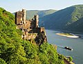
Koblenz, the northern gateway to the world heritage with the Ehrenbreitstein fortress
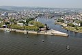
The Deutsches Eck at the mouth of the Moselle
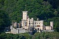
The Stolzenfels Castle near Koblenz, the epitome of the Romantic Rhine

The Marksburg near Braubach, the only hill fort in the Middle Rhine Valley that has never been destroyed


Description of the cultural landscape

criteria
The prerequisite for the criteria mentioned below is a closed landscape area that has a certain uniqueness and has been given a special design by people. In the Upper Middle Rhine Valley, this is the case in the Rhine breakthrough through the Rhenish Slate Mountains . The valley with its steep rocky slopes forced its use in the form of terraces that shaped the valley over the centuries. It was particularly characterized by the viticulture on terraces, which has been documented since the 8th century, slate extraction and coppice forest management . Agriculture was only possible on the plateaus. The large number of approx. 40 castles and palaces, which were built along just 67 kilometers of river, is also unique. The Upper Middle Rhine Valley is the epitome of Rhine romance and also the classic transport landscape (important shipping route, two federal highways and two railway lines).
location
The cultural landscape of the Upper Middle Rhine Valley essentially coincides with the main natural spatial unit of the Upper Middle Rhine Valley , but extends beyond this in the south and north. In the south, the natural area is expanded to include the urban areas of Bingen and Rüdesheim. At the northern end, large parts of Koblenz are also part of the world heritage; the city already belongs to the Middle Rhine basin . The World Heritage area thus includes cities that are important for the development of the cultural landscape. It stretches from Rhine kilometers 526 to 593 for a length of 67 km along the breakthrough valley of the Rhine through the Rhenish Slate Mountains between Bingen / Rüdesheim and Koblenz.
Pfalzgrafenstein Castle and Gutenfels Castle (background) near Kaub
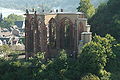
The ruins of the Werner Chapel near Bacharach
Rheinstein Castle , the first castle in the Middle Rhine Valley to be rebuilt in the 19th century

The Binger Loch is the southern gateway to the world heritage, on the left the Binger mouse tower , on the right the Ehrenfels Castle

The Niederwald monument with the Germania near Rüdesheim


Landscapes
The Upper Middle Rhine Valley is bounded by the Hunsrück to the west and the Taunus to the east. In Bingen, the Rochusberg is part of the world heritage before it enters the Rheinengtal via the Binger Loch . The valley itself is characterized by a barren, steep rocky landscape. The river has carved its way into the Rhenish Slate Mountains. Rocks and fossils are evidence of around 410 million years of geological history . The winding course of the river of the Rhine is still dangerous for Rhine shipping today due to its shallows . At the Loreley , the world-famous and legendary slate rock, there are the most dangerous rocks in the river.
In many places, wine is grown on the steep slopes . Most of the area belongs to the Middle Rhine wine-growing region , with a small part of the Rheingau wine-growing region in the south. The slopes of the valley are covered by dense forests. On the narrow banks of the Rhine or in the side valleys, the settlements crowd, over which a medieval castle sits enthroned on the rocky outcrops. In the northern part, the Bopparder Hamm forms the largest loop in the Rhine. After leaving the Rheinengtal and reaching the city of Koblenz, the World Heritage area ends in the Neuwied Basin shortly after the mouth of the Moselle at the Deutsches Eck .

Settlement structure
The area of the World Heritage cultural landscape of the Upper Middle Rhine Valley covers an area of around 620 km², with the core zone taking up around 273 km². Around 60 cities and municipalities are located here with a population of around 170,000 people. In Rhineland-Palatinate , parts of the independent city of Koblenz and parts of the districts of Mainz-Bingen , Mayen-Koblenz , Rhine-Hunsrück and Rhine-Lahn are part of the World Heritage area. In Hesse this is part of the Rheingau-Taunus district . On the left bank of the Rhine are the cities of Bingen , Trechtingshausen , Niederheimbach , Rheindiebach , Bacharach , Oberwesel , Sankt Goar , Hirzenach , Bad Salzig , Boppard , Spay , Brey , Rhens and Koblenz and on the right bank the cities of Rüdesheim , Assmannshausen , Lorch , Kaub , Sankt Goarshausen , Kestert , Kamp-Bornhofen , Filsen , Osterspai , Braubach , Lahnstein and Koblenz in the world heritage area.
Cultural monuments

The most outstanding cultural monuments are the castles, fortresses, palaces and church buildings along the Middle Rhine Valley. The Marksburg as the only undestroyed hilltop castle in the Middle Rhine Valley, Pfalzgrafenstein Castle , it is located on a rocky island in the middle of the Rhine, as well as Rheinfels Castle , which was developed into a fortress over time, are significant testimonies to the Middle Ages. The Stolzenfels Castle stands like no other castle as a synonym for the Rhine romanticism , which was not only limited to the reception of existing buildings, but also stimulated restoration and new buildings. The Electoral Palace in Koblenz was the last residence of the Elector of Trier until the French revolutionary troops smashed the electoral state.
The most powerful fortress in the world heritage area, the Koblenz fortress , was built by the Prussians in the 19th century. As part of the fortification system, Ehrenbreitstein Fortress towers over the Rhine Valley to this day . The oldest church buildings include the historic Romanesque basilica of St. Kastor (the first construction of which was consecrated in 836) in Koblenz, the collegiate church of St. Goar from the 11th century and the late Romanesque St. John's Church in Lahnstein, which was completed in 1136 as the earliest example of a gallery church on the Rhine. The Binger Mäuseturm , a former customs watchtower in the Rhine, the Niederwald monument with the Germania near Rüdesheim and the Deutsche Eck with the equestrian statue of Kaiser Wilhelm I at the mouth of the Moselle stand out as other profane and nationally known buildings . The Roman fort in Boppard is an important ground monument on the Middle Rhine . It is one of the best preserved of its kind in Germany.

Economy and Transport
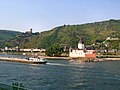
The most important traffic route of supraregional importance has always been the Rhine. The federal waterway is one of the busiest waterways in the world. With the breakthrough into the Rhenish Slate Mountains, the Middle Rhine Valley forms a special bottleneck due to its tight curves and shallows . In order to keep the risk to navigation on the Rhine as low as possible, there is the Wahrschau on the Middle Rhine . The B 9 on the left bank of the Rhine and the B 42 on the right bank of the Rhine are the most important roads in the Middle Rhine Valley. In addition, the high-volume railway lines run to the left and right of the Rhine.
tourism

The Middle Rhine Valley has been a tourist attraction since the 19th century . Young British nobles on the Grand Tour to Italy discovered the Middle Rhine in the 18th century. With the German Romanticism , the Middle Rhine became a destination of longing in Germany as well. The tourism triggered by the romanticism of the Rhine , promoted by the start of regular steamboat traffic by the Cologne-Düsseldorfers in 1827 and the construction of the railway in the 1840s to 1870s, brought the Middle Rhine a new economic boom that lasted well into the 20th century. The only paddle wheel ship still on the Rhine today is the Goethe , which operates between Koblenz and Rüdesheim.
The interest of German and foreign tourists in the Middle Rhine was never lost, but decreased noticeably from the 1980s onwards. In order to make the Middle Rhine more attractive again in the 21st century, two new long-distance hiking trails were opened, the Rheinsteig on the right bank of the Rhine and the Rheinburgenweg on both sides of the Rhine, which enable a particularly intensive experience of the cultural landscape.
As tourist events, wine festivals take place every year in the Middle Rhine Valley , as well as folk festivals in various places, at the end of which the Rhine fireworks are on fire . On the Spay-Koblenz route, the largest ship parade in Europe drives past Rhine castles and palaces illuminated in Bengali . It ends at Ehrenbreitstein Fortress , from where the largest fireworks in the Middle Rhine Valley are shot. The car-free Sunday Tal Total and the Middle Rhine Marathon are other major sporting events.
The World Heritage Host Cooperation, founded in 2007 , which requires members to have special quality standards and offers World Heritage tourists regional products and specialties , is particularly connected to the World Heritage . At a weekly meeting you get involved in joint activities and events, such as the Middle Rhine Moments .
The Romanticum in the Forum Confluentes in Koblenz houses an interactive exhibition on the topic of the UNESCO World Heritage Upper Middle Rhine Valley. Visitors get on board a virtual steamship and experience a journey through the Middle Rhine Valley, which is known for its romantic Rhine.
The noise from up to 20 trains per hour is likely to increase after the Gotthard Base Tunnel has opened; many of the hotels are privately owned and have not been renovated in a long time, prompting tourists to stay elsewhere.

View from the Siebenburgenblick observation tower on the Rheinburgenweg over the Rhine Valley between Trechtingshausen and Bacharach

View from the Hindenburghöhe on the Rheinsteig over the Rhine Valley near Bad Salzig


Formation of the cultural landscape
Castle building

The castles in the Upper Middle Rhine Valley were created with a few exceptions from the 12th to the first half of the 14th century. They were mostly built on the central terraces that were created when the valley was formed. In the 10th and 11th centuries, castle building was a privilege of the empire (king, high nobility). Buildings before this time were mostly made of wood and earth.
From the 12th century onwards, royalty began to weaken. The power of the princes grew (from 1220 and 1231 important rights ( regalia ) were transferred to the clergy ( Confoederatio cum principibus ecclesiasticis ) and secular ( Statutum in favorem principum ) imperial princes, from 1273 electoral kingship, 1356 final formation of territorial states). This was also the time when most of the castles were built. Four out of seven electors owned areas in the Upper Middle Rhine Valley. The political map showed a patchwork of patches as these areas were not contiguous. First the castles were built to secure the area. From the late 12th century onwards, the princes discovered customs as a source of income, so that now castles were built for customs security . Castles in the city ring were normally built as a fortress against the city dwellers striving for freedom.
Firearms appeared in the region at the end of the 14th century . By the 15th century at the latest, structural reactions were necessary that only wealthy castle owners could afford. Many castles lost their strategic importance as early as the late Middle Ages due to the use of firearms. Most of the time they started to deteriorate more slowly or they were given up.
Already in the Thirty Years War there was numerous destruction by troops passing through. The final destruction of almost all castles was then done by the troops Ludwig XIV. In the Palatinate War of Succession in 1689 (with the exception of the hill fortes only Ehrenbreitstein Fortress , Marksburg Castle and Rheinfels Castle ).
With the advent of the romanticism of the Rhine , many castles were rebuilt between 1815 and the end of the 19th century. For example, the later Prussian King Friedrich Wilhelm IV had the Stolzenfels castle ruins rebuilt as a castle in the style of historicism . The first castle ruin to be rebuilt by Karl Friedrich Schinkel and Johann Claudius von Lassaulx was Rheinstein Castle in the southern World Heritage section.
Viticulture

The Middle Rhine wine-growing region is largely identical to the geographical region, one of the “ specific growing areas ” for quality wine defined by the German Wine Act .
Viticulture was brought about by the Romans. However, it did not develop south from the Moselle until the Middle Ages . This development took place in four phases from the 11th to the end of the 14th century.
The new technique of terrace viticulture was essential for the development. Areas of 25 ° to 30 ° and more were built on. The cultivation was favored by the climate. The Rhine and the slate and greywacke weathered soils function as heat stores that prevent large fluctuations in temperature. In addition, there is good cold air drainage on the steep slopes. This is of particular benefit to the late ripening Riesling, which accounts for around 75% of the area under cultivation. The terraced viticulture was much more fragmented than the current situation shows, which only arose after land consolidation in the 1960s (see picture of bushy vineyard terraces - small terraces covered with bushes on the left and above the large slopes, recognizable by the many light, transverse lines). Unfortunately, with the old dry stone walls, a biotope for small organisms was also lost. In the Upper Middle Rhine Valley, some old terraces are still under cultivation (also recognizable by the old ties between the shoots - one post per floor).
In the Middle Ages, wine was the only germ-free and storable folk drink, as beer was usually bad and more expensive, coffee and tea were still unknown. A regional specialty that was traded far north was the production of fire wine in the Viertälergebiet around Bacharach (today again produced in the Posthof Bacharach). Wine was one of the most important trading goods in the Middle Ages, favored by the Rhine as the most important waterway and the remains of Roman roads. Therefore it was interesting for landlords (increase in value). The improvement of the legal, social and economic situation due to the increasing need for skilled workers led to new leases and an upswing. In the late Middle Ages, the majority of the population was dependent on viticulture. After the dissolution of many manors, it was split into many small parcels .

This branch of industry was booming until the end of the 16th century, then the Thirty Years' War led to recession and decline. Better beer prices as well as tea and coffee also reduced the proceeds. From 1815 onwards, due to the fact that it belonged to Prussia, there was again a great boom on the left bank of the Rhine (quasi monopoly ). From 1839 there was strong competition from the German customs union . This was the beginning of the transformation from full-time to part-time winemaker. In some cases there was additional profit from the romantic Rhine (Gutsausschank) and the emerging sparkling wine industry. From 1870 there was a new crisis because of the railroad (improved transport), industrialization, cheaper and better competition from abroad and the emergence of vine pests from America via France ( powdery mildew , phylloxera , downy mildew and hayworms and sourworms ). The deeper cause of the decline was the changed socio-economic conditions. Until the 19th century there was hardly any other way of earning a living. Then, because of the low profit, there was great migration to the emerging industry. The left side was more affected only after the Second World War (until then there was hardly any industry and more tourism). Despite the land consolidation carried out in 92% of the areas in the 1960s, there was a further decline due to the lack of profit.
58% of the vineyard areas that existed around 1900 are now completely and irretrievably fallow. Another 16% have a fallow share of 40–80%. Only around 480 hectares are left - the trend is downwards to approx. 380 hectares actually planted in 2006. The vineyards become bushy and are finally brought back from the forest. This is a big problem here. If you want to preserve the character of the landscape, great efforts are required to find new uses for the terraces, or at least to keep them open. The land consolidation in the Oelsberg near Oberwesel is a successful example of preserving viticulture without extensive earth movements in the landscape . By means of transverse terracing of the site and the installation of a drip irrigation system, former small plots could be kept under cultivation. In Bacharach, too, a gentle redesign to facilitate cultivation of the vineyards is being planned. Individual locations that shape the landscape, such as on the Roßstein across from Oberwesel, under Stahleck Bacharach Castle or around Gutenfels Kaub Castle, deserve continued cultivation in order to maintain the charm of the cultural landscape. Many castles now have abandoned and heavily bushed vineyards at their foot. The much-advertised postcard idyll supports a recovery , because the light, finely structured green and, in the autumn, rich yellow of the small parceled vineyards contrast well with the green of the forest. Despite land consolidation, mechanization is limited, as the areas are usually too steep to be driven on with wheel-driven tractors or grape harvesters. Therefore, profitability is only given for businesses that sell bottled wine, which usually earn additional income by renting out holiday apartments or by catering (typical wine and ostrich taverns ).
Mining

Iron and other ores have been mined on both sides of the Rhine Valley since Roman times. Shaft towers and processing companies were elements that shaped the landscape until after the Second World War, as the remains of the Amalienhöhe pit near Waldalgesheim attest. Almost completely disappeared from the landscape are the daytime facilities of the Gute Hope mine , which has been extracting lead and zinc ores on both sides of the Rhine near Sankt Goar and Sankt Goarshausen-Ehrenthal from the 18th to the 20th century .
In the lead and silver smelter near Braubach , silver was first mined from 1691 , then lead later . The three chimneys, which are clearly visible from the Rhine Valley, are striking, to which the smoke from the hut was directed via smoke channels up a hill.
The importance of slate mining for the Middle Rhine region is demonstrated by the listed site of the Wilhelm Erbstollen mine in Kaub .
Forestry

Large parts of the valley were originally forested. Alluvial forests of white willow grew in the river valley, oak and hornbeam on the slopes - and beech trees on better soils . The first economic use was made by the Romans, who also cleared arable and pasture areas. With the Carolingian expansion of the country (peak in the 13th century), there was an increase in settlement and population density. During this period, the vineyards were opened up and the use of the land on the terraces as arable and pasture areas began. At the end of the 14th century there was about 50% less forest. Now the economic importance was recognized and the use of the forest became vital for the region.
Types of forest use from the Middle Ages to the 19th century:
- The main use was the extraction of wood as construction and fuel as well as for the manufacture of equipment.
- The forest pasture provided food for the cattle through grasses and herbs in the high forest. When driving pigs in, acorns and beechnuts were used for fattening in autumn. Green leaves were also fed and used as stable litter. A popular method was "snowing" trees, that is, cutting off leafy branches to obtain fodder. Trees were also "put on the stick" by cutting them down to the rootstock. The stick swings were used as firewood about every seven years. This was only possible with tree species such as oak and hornbeam, as they have the ability to rejuvenate through new growth. In this way a “ coppice ” was created.
- In the forest-field alternation, the areas were used as arable land. After clearing by fire, an interim use as cultivation area followed for 1–3 years (e.g. rye), which was followed by fallow land of 10–20 years. Some of the areas were also used as pasture during the fallow period.
- An important source of income was the extraction of oak bark ( Lohe ). The trees were cut to about man's height and the bark peeled off with a spoon . These areas could also be used as arable land.
- Other forms of use were charcoal (charcoal for ore smelting), ash distillery ( potash for the glass industry), soap-making (as a bleaching agent) and the extraction of willow branches.
Today the valley is dominated by overgrown coppice forests. In many oaks this can be recognized by the knobbly growths above the rootstock. The last "drive" took place after the Second World War by the French as a reparation payment. Since the trees have become too big in the meantime, there is danger here because the barren slopes can no longer carry the load.
Threats to the cultural landscape
.jpg)

Traffic noise
Already in connection with the award of the world cultural heritage status, UNESCO stated that the noise generated by traffic (of which the railway lines play a significant part) was a problem. However, concrete measures were neither recommended nor required.
Middle Rhine Bridge
The planned new fixed Rhine crossing over the Middle Rhine Bridge near St. Goar and Sankt Goarshausen is to be coordinated with UNESCO in order to avoid problems like those with the Dresden Elbe Valley .
On July 29, 2010, UNESCO announced that the construction of a bridge was compatible with the world heritage. Thus, the concrete planning can begin. In the coalition negotiations after the state elections in 2011 , the SPD and the Greens agreed not to build the “Mittelrheinbrücke” project for the time being.
Rheinseilbahn Koblenz

The Rheinseilbahn, Germany's largest cable car, has been operating in Koblenz since July 2, 2010. The first 890 meter long tricable gondola built in an urban setting would also pose a threat to the World Heritage status. It was built as an attraction and ecologically sensible transport connection to the 2011 Federal Horticultural Show . That is why the organizers of the garden show agreed with UNESCO on the most inconspicuous design of the cable car structures. In addition, it was agreed to only operate the cable car until November 2013 and then dismantle it.
UNESCO decided on June 19, 2013 at the 37th session of the World Heritage Committee in Phnom Penh to allow operation until 2026. The technically longest possible service life ends this year.
Loreley summer toboggan run
The summer toboggan run on the Loreley rock, built in 2013, poses a threat to UNESCO status. On June 19, 2013 in Phnom Penh, UNESCO called for the run to be dismantled at the 37th meeting of the World Heritage Committee.
Protective measures
In order to preserve the world heritage, the outstanding cultural monuments on the Upper Middle Rhine are protected by the respective monument protection law of the federal states involved. This law regulates the preservation of monuments , the preservation and maintenance of cultural monuments as well as their scientific research . In addition, these structures are recognized by the Hague Convention for the Protection of Cultural Property in the Event of Armed Conflict . The Rhine Valley Charter , adopted in November 1997, aims to preserve, maintain and carefully develop the cultural landscape. The communities that have joined the charter ensure that the uniqueness of the cultural landscape is protected. Wild plants and animals are under the special protection of the Bern Convention , which is regulated at national level by the Federal Nature Conservation Act.
See also
- Upper Middle Rhine Valley World Heritage Association
- List of castles, fortresses and palaces in Rhineland-Palatinate
- List of castles and palaces in Hessen
literature
- Christian Schüler-Beigang (Ed.): The Rhine Valley from Bingen and Rüdesheim to Koblenz - A European cultural landscape. The central work (documentation for the UNESCO application). von Zabern, Mainz 2002, ISBN 3-8053-2753-6
- Erdmann Gormsen: The Middle Rhine Valley - A changing cultural landscape . Leinpfad, Ingelheim 2003, ISBN 3-9808383-2-3
- Marcel Dombrowsky: New tourist offers in the Upper Middle Rhine Valley - Influence of the new tourist offers on the regional economic boom . AVM, Munich 2011, ISBN 978-3-86924-014-5
- UNESCO World Heritage Upper Middle Rhine Valley. Topographic leisure map 1: 25000. Jointly published. from the State Office for Surveying and Geographic Base Information Rhineland-Palatinate and the Hessian State Office for Soil Management and Geoinformation. 2nd Edition. State Office for Surveying and Basic Geographic Information Rhineland-Palatinate, Koblenz 2005, ISBN 3-89637-363-3 , ISBN 3-89637-364-1 , ISBN 3-89637-365-X (set of three maps: Koblenz - Loreley - Rüdesheim / Bingen)
Web links
- Official website of the State of Rhineland-Palatinate on the Upper Middle Rhine Valley Cultural Landscape World Heritage Site
- Official homepage of the association
- Map of the World Heritage area (PDF; 6.82 MB)
- Application for inclusion of the Upper Middle Rhine Valley cultural landscape in the UNESCO World Heritage List (PDF; 251 kB)
Individual evidence
- ↑ Middle Rhine Valley is a World Heritage Site in: Rhein-Zeitung , June 27, 2002
- ↑ The Middle Rhine Valley is celebrating itself as a World Heritage Site in: Rhein-Zeitung , September 21, 2003
- ↑ Matthias Bartsch, Josef Saller: "Von Schönheit und Siff." Der Spiegel, March 12, 2016, p. 42f.
- ↑ UNESCO documentation of the State Office for the Preservation of Monuments (2002)
- ↑ Information on "steep slopes" and on the subject of "fire wine" at www.mittelrheintal.de or on request at the Middle Rhine visitor center Posthof 55422 Bacharach
- ^ The Rhine Valley from Bingen and Rüdesheim to Koblenz. A European cultural landscape. Volume 1. Published by the State Office for Monument Preservation Rhineland-Palatinate, Verlag Philipp von Zabern, Mainz 2001, ISBN 3-8053-2753-6
- ↑ Trembling before Unesco: The Middle Rhine Valley does not want to experience Dresden in: FAZ, July 7, 2008
- ↑ Rheinquerung Beck / Hering: World Heritage Committee clears the way for the Middle Rhine Bridge ( page no longer available , search in web archives ) Info: The link was automatically marked as defective. Please check the link according to the instructions and then remove this notice. Press release of the Ministry of Economics, Transport, Agriculture and Viticulture RLP of July 29, 2010
- ↑ Red-green is committed: The Hochmosel Bridge is coming - and the cabinet is in: Rhein-Zeitung , May 2, 2011
- ↑ Rhein-Seilbahn may stay until 2026 in: Frankfurter Allgemeine Zeitung , June 19, 2013

Cultural heritage:
Aachen Cathedral (1978) |
Speyer Cathedral (1981) |
Würzburg Residence with Hofgarten and Residenzplatz (1981) |
Pilgrimage Church on the Wies (1983) |
Palaces of Augustusburg and Falkenlust in Brühl (1984) |
Cathedral and Michaeliskirche in Hildesheim (1985) |
Roman monuments, cathedral and Church of Our Lady in Trier (1986) |
Historic Hanseatic City of Lübeck (1987) |
Palaces and Parks of Potsdam and Berlin (1990) |
Lorsch Abbey (1991) |
Rammelsberg mine, old town of Goslar and Upper Harz water management (1992) |
Maulbronn Monastery Complex (1993) | Old Town of Bamberg (1993) |
Collegiate Church , Castle and Old Town of Quedlinburg (1994) |
Völklinger Hütte (1994) |
Cologne Cathedral (1996) |
The Bauhaus and its sites in Weimar, Dessau and Bernau (1996, 2017) |
Luther memorials in Eisleben and Wittenberg (1996) |
Classic Weimar (1998) |
Museum Island Berlin (1999) |
Wartburg (1999) |
Dessau-Wörlitz Garden Realm (2000) |
Reichenau Monastery Island (2000) |
Zeche Zollverein and coking plant Zollverein (2001) |
Upper Middle Rhine Valley (2002) |
Old towns of Stralsund and Wismar (2002) |
Bremen Town Hall and Bremen Roland (2004) |
Fürst-Pückler-Park Bad Muskau (2004) |
Limits of the Roman Empire : Upper Germanic-Raetian Limes (2005) |
Old town of Regensburg with Stadtamhof (2006) |
Settlements of Berlin Modernism (2008) |
Prehistoric pile dwellings around the Alps (2011) |
Fagus factory in Alfeld (2011) |
Margravial Opera House Bayreuth (2012) |
Bergpark Wilhelmshöhe (2013) |
Carolingian Westwork and Civitas Corvey (2014) |
Hamburger Speicherstadt and Kontorhausviertel with Chilehaus (2015) |
The architectural work of Le Corbusier : two houses in the Weißenhofsiedlung (2016) |
Caves and Ice Age Art of the Swabian Alb (2017) |
Archaeological border complex Haithabu and Danewerk (2018) |
Naumburg Cathedral (2018) |
Ore Mountains Mining Region (2019) |
Augsburg water management system (2019)
Natural heritage:
Messel Pit (1995) |
Wadden Sea of the North Sea (2009) |
Old beech forests (2011)
Former World Heritage:
Dresden Elbe Valley Cultural Landscape (2004–2009)