
Danube city
|
Donaustadt XXII. Viennese district |
|
|---|---|
| coat of arms | map |
 |
 .svg) |
| Geographic location : | 48 ° 13 ' N , 16 ° 29' E |
| Surface: | 102.29 km² |
| Residents: | 195.230 (January 1, 2020) |
| Population density : | 1909 inhabitants / km² |
| Postal code : | 1220 |
| Address of the district office: |
Schrödingerplatz 1 1229 Vienna |
| Website: | www.wien.gv.at |
| politics | |
| District Head : | Ernst Nevrivy ( SPÖ ) |
|
District council election 2015 |
A total of 60 seats |
| Map: Donaustadt with parts of the district | |

|
|
The Danube city is 22 Viennese district . The district in the east of the city, which has only existed in this form since 1954, is by far the largest and, according to Favoriten, the most populous. The Danube city, which makes up almost a quarter of the Vienna municipal area, is characterized by a diverse appearance. In addition to large housing estates such as the Trabrenngrund and single-family housing estates, there is the office and high-rise residential area Donau City and the Seestadt Aspern , which is one of the largest current urban district development projects in Europe. The 22nd district is also home to important local recreation and nature reserves such as the Alte Donau and Lobau as well as part of the agricultural Marchfeld .
geography

Donaustadt is located in the east of Vienna and, with an area of 102.34 km², is the largest district in Vienna. The Danube city takes up 24.6% of the area of Vienna.
By the Danube regulation 1870-1875 the area of the today's district was radically changed. If the Danube originally fanned out into numerous arms reaching into the Marchfeld , it has now been forced into a wide bed. Existing oxbow lakes function as recreation and nature reserves. Since the danger of flooding was not finally defused, a relief channel known as the New Danube and the Danube Island were built parallel to the Danube in 1972–1987 .
The district border runs in the west largely on the left bank of the Danube (the river itself is part of the 2nd district), from the Praterspitz downstream (in the Lobau area ) in the middle of the river with the 11th district ( Albern district ) and Schwechat or its Mannswörth district as a neighbor. The southern part of the Danube Island, the Neuer and Alter Donau and the Lobau (Vienna's part of the Donau-Auen National Park ) belong to the district.
In the east and north, the Danube city has a share of the Marchfeld . In total, green spaces take up 59% of the district area, with 30% of all Vienna green spaces in the 22nd district.
The highest point in the district is the Rautenweg landfill at 205 meters above the Adriatic Sea.
Neighboring districts and municipalities
The districts Leopoldstadt and Simmering (Albern district) and the city of Schwechat (Mannswörth district) border the 22nd district in the west and southwest . The district border at Schwechat is also the state border with Lower Austria .
North of the Danube is the eastern and northern district borders, mostly in agricultural area, the full length of the national border; Neighboring communities here (from southeast to northeast) are Groß-Enzersdorf (with its share of the Donauauen National Park) and the Marchfeld communities of Raasdorf , Aderklaa , Deutsch-Wagram and Gerasdorf near Vienna .
The north-western district border opposite the 21st district Floridsdorf is formed (from north to south) first to Leopoldau from Wagramer Straße and then runs in a south-westerly direction through the settlement area and over the Old Danube to the Danube Island.
geology
The district area of the Danube city was mainly shaped by the Danube, which over time formed terraces . During the Ice Age in particular, large amounts of debris formed due to frost, which the Danube carried into the Vienna Basin . In the warm-time phases, the Danube subsequently cut into the gravel body and formed terraces which, in the district area, are subdivided into the "zone of recent meanders" near the Danube and the higher-lying Prater terrace. The slightly higher Prater terrace comes from the Würme Ice Age, the terrace below was created after the Ice Age.
More intensive weathering and a top layer of loess or loam are characteristic of older terraces . On the surface of the Danube city there is a five to thirteen meter thick layer of gravel. This is made up of sandy medium and coarse gravels that were landed by the Danube. The flat stones are usually sandstone from the nearby Vienna Woods . The round pebbles consist largely of crystalline rocks such as granite , gneiss and quartz . The granites, like the black amphibolites, come from the Bohemian Massif . The gray to greenish gneiss was removed from the Central Alps and the Bohemian Massif. Other round to oval gravels consist of lime and come from the Northern Limestone Alps . Under the gravel layer there is sands of the Pannonian , saturated with groundwater , which were deposited here 9.7 to 8 million years ago.
The foothills of the Northern Limestone Alps with layers from the Mesozoic era , which contain gas and oil deposits at a depth of around three kilometers, lie at a depth of several kilometers .
District parts

The Danube city has existed in its present size since 1954 (see section history):
- Kaisermühlen (1850–1938: 2nd district, 1938–1954: 21st district)
- Kagran (1904–1954: 21st district)
- Stadlau , Hirschstetten , Aspern (1904–1938: 21st district, 1938–1954: 22nd district, Groß-Enzersdorf )
- The Lobau floodplain (1904–1938: 21st district, 1938: 22nd district)
- Breitenlee , Essling , Süßenbrunn (incorporated in the new 22nd district, Groß-Enzersdorf, in 1938)
Today's cadastral communities are based on the former community boundaries. On the Danube lie from northwest to southeast Kaisermühlen, Stadlau and Aspern, to the north of which are Kagran, Hirschstetten, Breitenlee and Essling, and in the far north Süßenbrunn. The major part of Lobau is covered by the cadastral communities Landjägermeisteramt and Kaiserebersdorf Herrschaft. The newly built Donau City is also located in the Kaisermühlen district between the Old and New Danube .
The district area is further broken down into the 32 counting districts of the official statistics, in which the counting districts of the municipality are summarized. Although they have the same names as the corresponding cadastral communities, the counting districts Aspern, Breitenlee, Essling, Hirschstetten, Kagran, Kaisermühlen, Stadlau and Süßenbrunn have a borderline that differs from them. The counting districts industrial area Erzherzog-Karl-Straße and industrial area Neu-Kagran are named after industrial areas. The Eipeldauer Straße counting district has a street name as a designation. The other census districts of the Danube city are mostly based on settlement and field names. These are the counting districts An der Oberen Alten Donau, Biberhaufen, Breitenleer suburban settlement, Donaupark, Englisch Feld, Essling-Im Neuriss, Flugfeld Aspern, Freihof-Siedlung, Kriegerheimstätte-Lackenjöchl, Lettenhaufen, Lobau, Mühlgrund-Neu-Stadlau, Neu-Essling , Neuhaufen, Neu-Straßenäcker, Plankenmais, Schafflerhof, Asparagus Field, Neu-Kagran residential area, Wulzendorf and Kagran center.
Land use

The construction area of the Donaustadt comprises 25.00% (Vienna-wide 33.32%) of the district area, whereby this is the second lowest value of a Viennese municipality district. 57.4% of the building area itself is divided into residential areas and 28.4% into industrial areas. Donaustadt thus has a very high proportion of company premises. The proportion of areas dedicated to cultural, religious, sporting or public areas is very low at 6.0% of the building area. Green spaces make up a total of 58.4% in the Danube city. 51.87% of the green area is used for agricultural purposes, a value that is only exceeded by Favoriten and Floridsdorf . The majority of the remaining green area is accounted for by forests (Lobau) with 25.71% and meadows with 13.45%. With a share of 8.60% of the district area, bodies of water play a very important role in the type of use. The main factors here are the water bodies of the Danube and its oxbow lakes. The proportion of traffic areas in the district area is the second lowest value in Vienna at 8.02%.
| Construction area | Green space | Waters | Traffic areas | |||||||
|---|---|---|---|---|---|---|---|---|---|---|
| 2,556.29 | 5,968.42 | 879.17 | 819.98 | |||||||
| Housing | Service area | public facilities | Agriculture | Parks | Woods | grasslands | Allotments | Leisure areas | ||
| 1,466.46 | 724.69 | 153.36 | 3,095.72 | 100.24 | 1,534.20 | 256.41 | 802.61 | 179.24 | ||
Since 2013 there has been a project to partially reforest agricultural areas north of the Seestadt Aspern and to make it part of the Vienna Green Belt . This idea goes back to the head of the district at the time, after whom the project is named Norbert-Scheed-Wald .
history
Origin of name
The name Donaustadt was used at the end of the 19th century for an area in the 2nd district that was made usable as building land after the Danube regulation in the 1870s. Part of the fireworks corn (today's Stuwerviertel ) between exhibition street , Lassallestrasse and Danube as well as the area between Nordbahnhof and Danube were planned as a new part of the city and almost completely built up by the beginning of the 20th century. Since the name Donaustadt was apparently not used by the population and other Grätzl names were formed instead , it was chosen as the name for the new 22nd district in 1954. The name Donaustadt in its original meaning is still used today to designate the Roman Catholic parish Donaustadt around the Franz-von-Assisi-Church in the 2nd district and can also be found in historical newspaper reports or old city maps.
Before 1904
_-_L%C3%B6we_(Kriegerdenkmal).JPG)
The best-known historical event in today's district was the battle of Aspern and Essling fought by Archduke Karl with Napoleon Bonaparte in 1809 , the first military defeat inflicted on the Emperor of the French. The small Museum Aspern 1809 reminds us that memorial stones can be found in Lobau.
1785–1821 a popular magazine appeared in Vienna, for which the place name Kagran was used in the title: Letters from an Eipeldauer to his master cousin in Kakran about d'Wienstadt (Eipeldau = Leopoldau; Vetter = cousin). In a stylized dialect, a "farmer from Eipeldau", the neighboring town of Kagrans, commented on current local events and created a satirical picture of Vienna.
Kaisermühlen was the first part of the district that was incorporated into Vienna. Before the Danube regulation, located south of the main arm of the river, Kaisermühlen was incorporated with other areas as the 2nd district, Leopoldstadt, in 1850 and remained with the 2nd district until 1938 after the regulation, now on the northern bank of the new main stream. The name… mühlen refers to the numerous ship mills on the unregulated Danube.
The regular floods of the Danube in the Vienna region nourished the alluvial forest, today's national park, but disrupted economic development in the areas near the river. The regulation of the Danube in Vienna in 1870–1875 largely eliminated this problem; As a result, numerous oxbow lakes of the Danube were created in today's district area.
1904: 21st district
In 1904 the mayor of Vienna, Karl Lueger , managed to expand the city, which until then (apart from Kaisermühlen) had only spread out on the right bank of the Danube, to the left bank of the Danube. The places Floridsdorf , Jedlesee , Großjedlersdorf , Donaufeld , Leopoldau, Kagran, Hirschstetten, Stadlau and Aspern as well as the Lobau floodplain were incorporated by law, and in 1910 Strebersdorf as well. Around two thirds of today's 22nd district in the new 21st district came to Vienna.
In Red Vienna , 1919–1934, building activity began. The Goethehof in Kaisermühlen, the Freihofsiedlung in Kagran and other community buildings were built. Outdoor swimming pools were set up on the Old Danube .
1938: 22nd district, Groß-Enzersdorf
In 1938 the Nazi regime established Greater Vienna and partially restructured the city. The new 22nd district, Groß-Enzersdorf, built on October 15, 1938, was separated from the 21st district along the northern branch of the Ostbahn , so that at that time Kagran remained with the 21st district, Stadlau, Hirschstetten, Aspern and the Lobau for the 22nd . District. Kaisermühlen was then reclassified from the 2nd to the 21st district.
1945: In the Soviet sector
After the Second World War , the Danube city was occupied by the Soviets from mid-April 1945 to autumn 1955 (in Vienna they say: “Russian”) (see: Occupied Post-War Austria ). According to the agreements of the four allies, Vienna was divided into four sectors within its 1937 borders . The district area, which was only incorporated in 1938, was part of the state of Lower Austria under occupation law, and thus part of the Soviet zone of occupation in Austria.
1946/1954: 22nd district, Donaustadt
The politicians of Vienna and Lower Austria agreed to reintegrate most of the Lower Austrian municipalities that were incorporated in 1938. Of the 15 Marchfeld communities that came to Vienna in 1938, only Süßenbrunn, Breitenlee and Essling were to remain near Vienna. Vienna (state parliament decision of June 29, 1946), Lower Austria and the federal government passed corresponding constitutional laws.
Due to an objection by the Soviet occupying power in the Allied Council, the territorial change laws could not come into force for the time being. It was not until 1954 that the Soviet representatives approved the project. Now the district division law of Vienna could be announced and came into force on July 2, 1954. The district got its current name Donaustadt, because the district of Groß-Enzersdorf, which had been named after that, became an independent municipality in Lower Austria again. The border to the 21st district was moved to the Wagramer Straße or north of it. Kagran and Kaisermühlen now belonged to the 22nd district.
The last few decades
Later the border to the 21st district changed four times. In 1964, the district border in the area of the eastern Aderklaaer Strasse and in the area of the Bruckhaufen in Donaufeld was moved slightly. In 1995, the limits were adjusted in the area of Zehdengasse and Eipeldauerstraße. The border course to Floridsdorf changed over long stretches in 2002 in the areas of Oskar-Grissemann-Strasse, Josef-Baumann-Gasse, Alte Donau, Drygalskiweg and Wagramer Strasse. Traffic areas in particular were affected by these border changes; in addition, the Danube city received a larger share of the water area of the Old Danube and in return lost the large sports facility in Eipeldauer Straße to Floridsdorf.
In 1964 the Vienna International Garden Show (wig64) was held on the site of a former garbage dump and a wild settlement (“Bretteldorf”). For this purpose, the Danube Tower was built on the northern edge of the area . The UNO-City , which opened in 1979 , the international conference center Austria Center Vienna , which opened in 1987, and, from 1993, the Danube City as a new district, were built between the area known today as the Danube Park , Wagramer Strasse and the Neue Donau . The associated bank of the New Danube at the Reichsbrücke is known as the "Copa Cagrana".
In 1973 two power plant units of the Donaustadt steam power plant were put into operation on Steinsporn . Those responsible kept the option open of implementing the planned Unit 3 as a nuclear power plant .
The Donauspital , also known as the East Social Medicine Center (SMZ-East), was built between Stadlau and Aspern from 1978–1998 . It is the second largest hospital in Vienna.
With the exception of Stadlaus, the former suburbs of Vienna used to be rural. Their former village centers are still visible today. To this day, large areas are used for gardening or agriculture. As a result, the district was the most sparsely populated in Vienna for a long time. This only changed in recent years due to intensive urbanization.
population
Population development
Source: Statistics.at
Population development
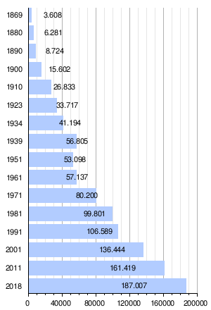
The current district area of Donaustadt shows the strongest population growth of all Viennese districts. Due to the large area of today's district area and the horticultural or agricultural use, large areas were and are available for advancing urbanization. The protection of the Lobau , which has a large proportion of the area in the district, also restricts urbanization. Even before the incorporation, the then still independent municipalities showed very high growth rates. Between 1869 and 1910 the population had already increased eightfold. The high growth continued at a somewhat lower level until 1939 and doubled again. After stagnation in the 1940s and 1950s, high growth set in again in the 1960s, which to this day is one of the highest values of all municipal districts. At the beginning of 2015, Donaustadt had a population of 172,798 people, making it the district with the second largest population after favorites . Nevertheless, the district is still comparatively sparsely populated today. The population density was 1,689 inhabitants / km² at the beginning of 2015, only the district of Hietzing is less populated.
Population structure
In 2005, the population structure in the Danube city was significantly younger than the average in Vienna. The number of children under the age of 15 reached the highest level in Vienna (14.6%) with a share of 18.0% of the district population. The proportion of the population between 15 and 59 years of age was 62.9% (Vienna: 63.4%) about the Vienna average, while the proportion of people aged 60 or more was 19.1% (Vienna: 22, 0%) was in the lower range of the Vienna districts. The gender distribution in the 2001 district area was 47.8% men and 52.2% women, the number of the married population with a share of 43.9% compared to 41.2% was above the average for Vienna.
Origin and language
The proportion of foreign residents in the district was 9.7% in 2005 (Vienna: 18.7%). This was the second lowest value in a Viennese municipality. As in the entire federal state, however, the proportion of foreigners is growing; in 2001 the proportion was 7.4%. The highest proportion of foreigners in 2005 was made up of around 1.6% of the district population, citizens of Serbia and Montenegro . Another 0.8% were Turkish , 0.8% Polish and 0.6% German citizens. In 2001, a total of 15.9% of the district population was not born in Austria. 2.3% spoke Serbian as the colloquial language , 1.9% Turkish and 1.1% Croatian .
Creed
At 54.7%, Donaustadt has one of the highest proportions of people with Roman Catholic faith in Vienna (49.2%). This is u. a. due to the low proportion of migrants of other faiths compared to other districts. There are 13 Roman Catholic parishes in the municipality, which make up the 22 city dean's office . In contrast, the proportion of people with an Islamic faith (4.3%) and Orthodox believers (2.8%) are well below the average (Vienna: 7.8% and 6%, respectively). The proportion of Protestant residents was 4.5% within the framework of Vienna as a whole. In 2001, 28.7% of the district population did not belong to any religious community, whereby this was the second highest value of a Viennese district. Another 5.1% of the population had given no or a different religion.
politics
| District chairman since 1945 | |
|---|---|
| Mathias Böhm ( KPÖ ) | 1945-1946 |
| Leopold Horacek ( SPÖ ) | 1946-1959 |
| Rudolf Köppl ( SPÖ ) | 1959-1977 |
| Rudolf Huber ( SPÖ ) | 1977-1981 |
| Albert Schultz ( SPÖ ) | 1981-1993 |
| Leopold Wedel ( SPÖ ) | 1993-1997 |
| Franz-Karl Effenberg ( SPÖ ) | 1998-2005 |
| Renate Winklbauer ( SPÖ ) | 2005-2006 |
| Norbert Scheed ( SPÖ ) | 2006-2014 |
| Ernst Nevrivy ( SPÖ ) | 2014– |
The communist Mathias Böhm was initially appointed by the Soviet occupying power as the first district head of the 22nd district. He was followed by the Social Democrat Leopold Horacek . Due to the unclear status of the district until 1954, there were no district representative elections in the Donaustadt. Horacek was eventually confirmed in the 1954 district council elections. To this day the district has remained firmly in the hands of the Social Democrats. As recently as 1991, the SPÖ was able to unite around 55% of the votes before it lost its absolute majority for the first time after the rise of the FPÖ (around 29%) in the 1996 elections with around 43%. However, in the 2001 district council elections, the SPÖ was able to recapture an absolute majority with around 54.25%.
In the 2010 district council elections, the picture looked almost the same again: SPÖ (47.9%), FPÖ (30.2%), ÖVP (9.5%), the Greens (8.7%) and the KPÖ (1st , 4%) and the newly founded BZÖ (1.1%). In 2015 the SPÖ was able to hold first place with 40.7% despite losses, the FPÖ reached 36.7%, followed by the Greens with 8.5% and the ÖVP with 6.9%. NEOS also moved into the district representation with 4.7%.
coat of arms
The coat of arms of the Danube city is divided into eight fields, which represent the districts. In the upper left part of the coat of arms is the speaking coat of arms of the Stadlau with a barn in the Au. The barn stands on a green meadow with trees and is on a blue background. The barn itself is locked and has a thatched roof and two red flags on it. To the right of it is the coat of arms of Aspern . The speaking coat of arms shows an aspen standing in a meadow on a silver background . In the upper right part of the coat of arms, a golden draw well symbolizes the Süßenbrunn district . The coat of arms, which refers to a fountain that once existed here, shows the fountain standing on a gray stone floor against a blue background. The fountain is covered and a golden bucket hangs on a rope. In the middle part of the coat of arms, the coat of arms of Breitenlee is shown on the left. It shows a red shield crossed by a silver crossbar with a golden crook and a red pouch book . The coat of arms figure is taken from the coat of arms of the Schottenstift , which still operates an estate in Breitenlee today. In the center of the coat of arms is the depiction of Saint George as a dragon slayer in golden armor on a silver horse. The representation represents the Kagran district and goes back to the patronage of the Kagran parish church . The coat of arms of Essling follows on the right . It shows a golden eagle's wing adorned by a sash with a diamond pattern on a red and silver field divided across. The coat of arms is taken from the coat of arms of the Lords of Eslarn. In the lower area of the coat of arms on the left there is a golden ship's mill on a blue background for the Kaisermühlen district . It symbolizes the numerous ship mills that were once here. To the right of it, a golden tens leaping on a green meadow in front of a red background represents the district of Hirschstetten as a speaking coat of arms .
Economy and Infrastructure
The snack manufacturer Kelly is based in the Danube city.
traffic
Railway, S-Bahn
The first and for a long time most important railway in Austria, the Nordbahn , which opened in 1837 , crosses the district area in Süßenbrunn , which was incorporated in 1938. In 1962 Vienna's first rapid transit railway was set up on this route . Near the Süßenbrunn station, but mostly in the area of the neighboring municipality of Gerasdorf in Lower Austria, there are loops for connecting the northern and eastern railways , via the long-distance trains of the northern railway (to / from Vienna Central Station , formerly to / from the southern railway station, east side ) and S-Bahn -Trains are guided. The Süßenbrunn disinfection station is entirely located in Gerasdorf.
In 1870 the Eastern Railway was opened in the district area. A railway junction was built in the later district of Stadlau: the route coming from the south from the other bank of the Danube divides here into the northern branch towards Moravia and the eastern branch towards Pressburg , on which the Orient Express once operated. Industry settled around the station. Since the area through which the two eastern railway branches were built was very sparsely populated, the routes could be traced as if drawn with a ruler. During the First World War , the Breitenlee marshalling yard built between the two eastern railway branches (of which only remains exist today) was of great importance for the transport of troops and materials. S-Bahn operations have been set up on the Pressburger Ostbahnast in recent decades .
Steam tramway
1886–1970 the later 22nd district was opened up by a tram line that began in Floridsdorf (where it was connected to a line from the city center) and led via Kagran, Aspern and Essling to Groß-Enzersdorf. The steam tramway had its departure point in the city center at today's Salztorbrücke, later at today's Augartenbrücke. In 1901 there were five trains per day in each direction.
tram
On January 23, 1922, the city trams began operating under the line signals 217 (mostly Kagran – Aspern, to Essling in World War II) and 317 (Kagran – Groß-Enzersdorf) in the direction of Essling. (The Floridsdorf – Kagran section had been integrated into the electric tram network as line 17 as early as January 23, 1912 and is now used by lines 25 & 26.) At the end of the war in 1945, both lines had been more than seven months (April 7–14 November). The stop Englisch-Feld-Gasse in Essling was the tariff limit. If you wanted to continue to Groß-Enzersdorf, you had to buy a second ticket from the conductor. From July 16, 1966, the 217 and 317 were operated from Floridsdorf. On August 30, 1970 the tram service on this route was stopped, from August 31, 1970 buses operated here.
The following lines also operated as electric trams in the 22nd district, coming from / via Praterstern and Reichsbrücke , and used parts of Wagramer Strasse (line signals with numbers and letters from 1907):
- 25: Praterstern – Kagran (1898, from 1962 to Kagraner Friedhof), extended at peak times as 25R and 25K via Praterstraße, Ringstraße and Franz-Josefs-Kai or Kai and Ring, since 1982 on the Kagran – Leopoldau route, there in 2006 also replaced by the U1
- 16: Praterstern – Stadlau via Erzherzog-Karl-Straße (1911–1971), since the extension to Donauspital in 1971 from Schottenring and designated as line 26, later extended to Aspern, from 1982 from Kagran, today as line 25 from Floridsdorf via Kagran guided
- 24: Schottenring – Kaisermühlen via Taborstraße (1900), Heinestraße and Schüttaustraße (1899), 1938–1959 also as 24R and 24K via Ring and Kai, and from 1937–1960 as line C from Hernals, Wattgasse, from 1940 Teichgasse, via Schottenring guided; 1965 by the extension of the lines A and Ak, in 1966 replaced by the lines B and Bk (Kaisermühlen-Praterstraße-Ringstraße-Franz-Josefs-Kai-Praterstraße-Reichsbrücke-Kaisermühlen or via Kai and Ring) ; Kaisermühlen has been served by bus routes since 1982
The Kagran depot for the municipal trams was located on Wagramer Strasse near the junction with Erzherzog-Karl-Strasse.
Lines 25 and 26, which connect Floridsdorf with Aspern and Strebersdorf with Seestadt Aspern , are currently operating in the Donaustadt district area. As part of the extension of the U2 to Seestadt Aspern in October 2013, a new line was built for the 26er, partly in an elevated position, which leads from Kagraner Platz via the Stadlau industrial park to Hirschstetten and on to the U2 station Hausfeldstraße . In the previous year, a new connection was built for line 25 from Donaufelderstrasse in the area of the University of Veterinary Medicine to the Kagran Center.
Air traffic
Vienna 's Aspern Airport, serving international traffic, was located in the 22nd district from 1912 to 1954 . During the “Anschluss” in 1938, planes of the German Air Force landed here . In 1954 Schwechat Airport took over international traffic; In 1977 the "airfield" was also closed to sports aircraft. As Seestadt Aspern , the area is to be expanded into a new district, which on October 5, 2013, before most of the buildings were completed, received an underground connection to the U2 line .
Danube shipping
In 1939/40 the German Reich wanted to implement the long-standing plans for the Danube-Oder Canal . However, the war only allowed the construction of four smaller sections to Groß-Enzersdorf. Two of them, the junction from the Danube and a section in the Lobau, which has been “left in its natural state” since it was built, are now in Vienna's urban area and thus in the 22nd district. At the junction from the Danube, the Lobau oil port with the so-called central tank farm was also built. The Danube-Oder Canal separates the Upper Lobau from the Lower Lobau.
Subway

In 1976 the Reichsbrücke , a chain bridge, collapsed . For this reason, the subway construction was brought forward to the 22nd district and the new Reichsbrücke, opened in 1980, with a basement for the U1 was built. In 1982, operations began on the new Praterstern – Kagran section, and in 2006 on the extension to Leopoldau (S-Bahn connection). The U2 line has been running to Aspernstrasse since 2010 . On October 5, 2013, a further extension to the newly emerging district on the area of the former Aspern Airport took place.
Streets
The first completely new Danube bridge in Vienna in the 20th century was the Prater Bridge , opened in 1970 , which reaches the 22nd district at the southern end of the Old Danube and leads over the A 23 city motorway called the southeast bypass . In the course of the construction of the New Danube, the Danube bank motorway A 22, which is largely routed in a tunnel, was built on the banks of the Danube city until 1989 , the southern end of which is connected to the south - east bypass at the Kaisermühlen motorway junction. From here you can reach the Lobau central tank farm via the Raffineriestraße, which is also parallel to the Danube. (The planned extension of the outer ring expressway S 1, which currently ends on the east autobahn A4 in Schwechat, via a new bridge over the Danube and a Lobau tunnel - an ecologically controversial project - should possibly be connected to the Raffineriestraße.)
The south- east bypass is extended northward from Hirschstetten by the north edge expressway S 2 (mostly roughly parallel to the northern branch of the Ostbahn ), which leads to Wagramer Strasse near Süßenbrunn and the northern city limits. From the future Süßenbrunn junction, the autostraße merges into the Vienna outer ring expressway S 1, to which the A 5 northern motorway towards the Czech Republic connects at the Eibesbrunn junction and continues on to Korneuburg on the A22.
Infrastructure constructions

Power generation
- The Donaustadt steam power plant was built between 1969 and 1973 and expanded to include Unit 3, which opened in 2001.
- The Danube power plant Freudenau was built between 1992 and 1998.
Disposal facilities
- The Rautenweg landfill is the only landfill in Vienna.
- The Lobau composting plant was set up in 1991.
- The Rinterzelt is a waste treatment facility of the City of Vienna and was originally built in 1980/81 by a private company.
health
- The Social Medical Center Ost - Donauspital was put into operation in several stages between 1978 and 1998.
schools
- The HTL Donaustadt was built in 1983.
- The vocational school for horticulture and floristry with the Kagran school garden and the Austrian horticultural museum .
Sports
- The Albert Schultz ice rink was built for the 1996 ice hockey world championship .
- The Gänsehäufel is an urban bathing facility on the Old Danube .
- The Alte Donau lido is a municipal bathing facility on the Alte Donau.
Event center
- The Austria Center Vienna was built between 1983 and 1987 as a conference center and is mainly used for congresses, trade fairs and balls.
Others

- The Hirschstetten flower gardens are primarily used to raise flowers for regular planting in the urban green spaces.
- The Donau Zentrum is Vienna's largest shopping center.
- The Lobau groundwater works was built to secure Vienna's water supply .
- The Donau-Auen National Park is also partly located in the Danube city.
- The New Danube was built between 1972 and 1988 as flood protection and, together with the Danube Island, forms an important local recreation area for Vienna.
- The Vienna International Center is commonly referred to as the UN City and was established between 1973 and 1979 as the third official seat of the UN.
- The Seestadt Aspern district has been under construction on the former Aspern airfield since 2009 .
Personalities
- David Alaba
- Reinhard Divis
- Georg Raphael Donner
- Fatty George
- Bill Grah
- Yung Hurn
- Helmut Lang
- The Nino from Vienna
- Thomas Prager
- Josef Sara
- Robert Sara
- Rudi Stohl
Culture and sights
Attractions

- Vienna International Center (“UNO City”) with the Austria Center Vienna
- Danube Tower
- Pope Cross
- Donau Zentrum (Vienna's largest shopping center)
- Vienna Danube Island
- Old Danube with the goose heap
- Part of the Donau-Auen National Park lies in the 22nd district.
- Rinterzelt , a waste sorting plant that characterizes the cityscape of Vienna
- Essling bulk box in Essling
- Hirschstetten swimming pond in Hirschstetten
Museums

The Donaustadt District Museum is located on Kagraner Platz and its permanent exhibition shows the history of the districts. The Austrian Horticultural Museum in Kagran has housed the largest domestic collection on Austrian horticulture and allotment gardening since 1977. The collection was expanded in 2001 by the Sädtler Collection (Austrian Museum of Flower Binding). The special museum Aspern-Eßling 1809, like the museum in the Schüttkasten Eßling, is dedicated to the battle of Aspern . The Lobau Museum, founded in 1972, provided information about the ecology of the Lobau and Danube floodplains as well as the local fauna and flora until it was closed in 2009 . In addition, the history of Lobau and the work of General Field Marshal Archduke Karl were presented.
Site design
In 2004, Donaustadt was awarded a gold medal in the city category as part of the European “ Entente Florale Europe ” competition.
Parks and cemeteries

The approximately 800,000 m² Danube Park in Kaisermühlen was created for the Vienna International Garden Show (WIG 1964). The Hirschstetten flower gardens with a branch in Eßling serve mainly as a cultivation facility for the municipal garden authority. In addition, the site also includes themed gardens on plants and animals that can be visited. Hirschstetten is also home to the Hirschstettner Aupark, a former alluvial forest and now a landscape park of around 32,000 m². On the premises of the vocational school for horticulture and floristry in Kagran is the Kagran school garden with several themed gardens, including a Japanese garden . Many of the smaller parks in the 22nd district were only created in the 1990s. These include the 3700 m² Bill-Grah-Park near the former Eßlinger Löschwasserteich, the 6500 m² Jakob-Bindel-Park, the 2200 m² Jakob-Rosenfeld-Park and the 4000 m² Trygve-Lie-Park im Norwegian quarter . Also worth mentioning is the cherry blossom park behind the Albert Schultz ice rink, which was named in 2003 and greatly enlarged in 2015.
With the exception of Kaisermühlen, each of the eight districts has its own cemetery. The largest in terms of area is the Aspern cemetery , while the Kagran cemetery has most of the grave sites. The oldest existing cemetery in the Danube city is the Esslinger Friedhof and the youngest is the Breitenleer Friedhof , consecrated in 1909 . Then there are the Hirschstetten cemetery , the Stadlau cemetery and, as the smallest cemetery in the 22nd district, the Süßenbrunn cemetery .
Town twinning
See also
literature
- Liselotte Hansen-Schmidt: Donaustadt. City on the other bank. Mohl, Vienna 1992.
- Edith Müllbauer: XXII. Danube city. Jugend & Volk, Vienna 1985. (Viennese district culture guide)
- Helfried Seeman (Ed.): Donaustadt 1860–1960 (Kagran, Hirschstetten, Stadlau, Aspern, Eßling, Breitenlee, Süßenbrunn, Kaisermühlen, Lobau) Verlag für Photographie, Vienna 1996.
- Birgit Trinker, Michael Strand: Vienna district handbooks. 22nd district - Donaustadt . Pichler Verlag, Vienna 2001, ISBN 3-85431-231-8 .
Web links
- Donaustadt on the website of wien.at
- Entry on Donaustadt in the Austria Forum (in the AEIOU Austria Lexicon )
- District Museum Donaustadt
Individual evidence
- ↑ Statistics Austria - Population at the beginning of 2002–2020 by municipalities (area status 01/01/2020)
- ↑ District council elections 2015
- ↑ Thomas Hofmann: Donaustädter Geologie - a well-rounded affair . In: Vienna district handbooks. 22nd district of Donaustadt . Vienna 2002, pp. 15-18
- ↑ a b Municipal Department 5 (MA5): Types of use by district ( Memento from September 29, 2007 in the Internet Archive ) (PDF) Municipal Department 5 (MA5)
- ↑ https://www.wien.gv.at/umwelt/wald/erendung/wienerwald/norbert-scheed-wald.html
- ^ Meyers Konversationslexikon 1885-1892
- ^ Wiener Zeitung : And Vienna grew across the Danube ( Memento from May 26, 2009 in the Internet Archive )
- ↑ Vienna planners 19th century
- ↑ aeiou.at
- ^ Ordinance of the Mayor of the City of Vienna on the division of the area of the City of Vienna into districts of October 15, 1938
- ↑ Law of January 31, 1964 on a minor change in the border between the 21st and 22nd district (LGBl. For Vienna 6/1964), issued on April 9, 1964.
- ↑ Law of July 31, 1964 on a minor change in the border between the 21st and 22nd district (LGBl. For Vienna 23/1964), issued on December 21, 1964.
- ↑ Law on changing the border between the 21st and 22nd district (LGBl. For Vienna 49/1995), issued on June 23, 1995.
- ↑ Law on changing the border between the 21st and 22nd district (LGBl. For Vienna 39/2002), issued on September 18, 2002.
- ↑ Census of May 15, 2001. Final resident population and number of citizens (with population development since 1869). District of Vienna: Vienna 22nd, Donaustadt , on Statistics.at (PDF, 12 kB).
- ↑ a b c Statistics Austria (2001 census) statistik.at (PDF; 11 kB) statistik.at (PDF; 11 kB)
- ↑ Resident population by age group and district 2006 ( Memento of September 29, 2007 in the Internet Archive ) (PDF) MA 5
- ↑ MA 5 Resident Population by Nationality and District 2001-2005 ( Memento from June 17, 2009 in the Internet Archive )
- ↑ wien.at - District coat of arms of the 22nd district ( Memento from March 8, 2009 in the Internet Archive )
- ^ Walter Krobot, Josef Otto Slezak, Hans Sternhart: Tram in Vienna - the day before yesterday and the day after tomorrow . Verlag Josef Otto Slezak, Vienna 1972, ISBN 3-900134-00-6 , p. 305 ff.
- ↑ U2 on an extended route. (No longer available online.) Wiener Linien, archived from the original on December 14, 2013 ; Retrieved October 10, 2013 .
- ↑ S 1 Vienna outer ring expressway. ( Memento from May 12, 2013 in the Internet Archive ) ASFINAG; accessed December 11, 2013.
- ↑ PORTRAIT: THE NINO FROM VIENNA. In: musicaustria.at. January 2, 2012, accessed October 26, 2018 .
- ↑ Blumenbuero.or.at
- ↑ Bilateral Relations - Sister Cities. Japanese Embassy Vienna, accessed January 13, 2009 .
Aspern |
Breitenlee |
Essling |
Hirschstetten |
Kagran |
Kaisermühlen |
Stadlau |
Süßenbrunn
Lobau (KG Kaiserebersdorf Herrschaft and KG Landjägermeisteramt)
1., Inner City | 2., Leopoldstadt | 3rd, highway | 4., Wieden | 5th, Margareten | 6., Mariahilf | 7., new building | 8., Josefstadt | 9., Alsergrund | 10., Favorites | 11., Simmering | 12., Meidling | 13., Hietzing | 14., Penzing | 15., Rudolfsheim-Fünfhaus | 16., Ottakring | 17th, Hernals | 18., Währing | 19., Döbling | 20th, Brigittenau | 21., Floridsdorf | 22., Donaustadt | 23rd, Liesing