
Delouze-Rosières
| Delouze-Rosières | ||
|---|---|---|

|
|
|
| region | Grand Est | |
| Department | Meuse | |
| Arrondissement | Commercy | |
| Canton | Ligny-en-Barrois | |
| Community association | Portes de Meuse | |
| Coordinates | 48 ° 34 ' N , 5 ° 31' E | |
| height | 295-405 m | |
| surface | 15.08 km 2 | |
| Residents | 113 (January 1, 2017) | |
| Population density | 7 inhabitants / km 2 | |
| Post Code | 55130 | |
| INSEE code | 55148 | |
 Town hall ( Mairie ) of Rosières |
||

Delouze-Rosières is a French commune with 113 inhabitants (as of January 1, 2017) in the Meuse department in the Grand Est region (before 2016 Lorraine ). It belongs to the Arrondissement Commercy , the canton Ligny-en-Barrois (until 2015 Gondrecourt-le-Château ) and the municipality of Portes de Meuse .
geography
Delouze-Rosières is surrounded by the neighboring communities Badonvilliers-Gérauvilliers in the southeast, Abainville in the south, Houdelaincourt in the southwest, Demange-Baudignécourt in the northwest and Mauvages in the northeast.
history
On January 1, 1973, the previously independent municipalities of Delouze and Rosières-en-Blois merged to form today's municipality of Delouze-Rosières.
Population development
| year | 1962 | 1968 | 1975 | 1982 | 1990 | 1999 | 2006 | 2011 | 2016 |
| Residents | 111 | 94 | 138 | 142 | 133 | 135 | 132 | 130 | 117 |
| Source: Cassini and INSEE | |||||||||
Attractions
Delouze
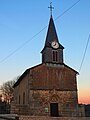
- Saint-Pierre-de-Vérone church, built in the 18th century
Rosières-en-Blois
- Saint-Génébaud church, built in the 18th century

Saint-Pierre-de-Vérone church
Saint-Génébaud church


literature
- Le Patrimoine des Communes de la Meuse. Flohic Editions, Volume 1, Paris 1999, ISBN 2-84234-074-4 , pp. 488-489.