
Chalaines
| Chalaines | ||
|---|---|---|

|
|
|
| region | Grand Est | |
| Department | Meuse | |
| Arrondissement | Commercy | |
| Canton | Vaucouleurs | |
| Community association | Commercy-Void-Vaucouleurs | |
| Coordinates | 48 ° 36 ' N , 5 ° 41' E | |
| height | 245-373 m | |
| surface | 8.1 km 2 | |
| Residents | 318 (January 1, 2017) | |
| Population density | 39 inhabitants / km 2 | |
| Post Code | 55140 | |
| INSEE code | 55097 | |
_vue_du_village.JPG) View of the village |
||

Chalaines is a French commune with 318 inhabitants (as of January 1, 2017) in the Meuse department in the Grand Est region ( Lorraine until 2015 ); it belongs to the Arrondissement Commercy and the community association Communauté de communes de Commercy-Void-Vaucouleurs . The residents call themselves Chalainois / Chalainoises.
geography
Chalaines is located around 18 kilometers southwest of the small town of Toul in the south of the Meuse department on the border with the Meurthe-et-Moselle department . In terms of traffic, the municipality is far away from national traffic routes near the D964. The place is on the Meuse . Large parts of the east of the municipality are forested (La Fouée). The community consists of the villages of Chalaines and Le Petit Chalaines and a few individual farms.
Neighboring municipalities are Rigny-la-Salle in the northeast, Rigny-Saint-Martin in the east, Gibeaumeix (in the Meurthe-et-Moselle department) in the southeast, Sepvigny in the south, Neuville-lès-Vaucouleurs in the southwest and Vaucouleurs in the west.
history
Like all places in the area, Chalaines suffered from conflicts in the Middle Ages. The worst devastation was caused by the Hundred Years War and the Thirty Years War . The name of today's parish was first mentioned in a document in 1340 under the current name Chalaines . In the Middle Ages the place belonged to the Barrois mouvant and was part of the Champagne . Chalaines was part of the Bailliage Chaumont. Until the French Revolution , the place was in the Grand-gouvernement de Lorraine-et-Barrois .
Chalaines was part of the Gondrecourt district from 1793 to 1801. Also since 1793 to the canton of Vaucouleurs. The parish has been assigned to the Arrondissement of Commercy since 1801.
Population development
The parish shares the fate of many rural parishes in France. In the first half of the 19th century the population was always more than 500 inhabitants. This was followed by rural exodus, which greatly reduced the number of residents (1851–1975: −55.6 percent). The population has grown again in the last few decades (1975–2016: +26.2 percent).
| year | 1793 | 1851 | 1962 | 1968 | 1975 | 1982 | 1990 | 1999 | 2006 | 2011 | 2016 |
| Residents | 570 | 577 | 329 | 292 | 256 | 281 | 291 | 297 | 318 | 326 | 323 |
| Sources: Cassini and INSEE | |||||||||||
Attractions
- Castle Château de Chalaines 18th century
- Village church Église de la Nativité de-la-Bienheureuse-Vierge-Marie
- Fontaine au Dauphin fountain from 1856
- Town hall (Mairie) and village school
- Memorial to the Fallen
- Two wayside crosses
- Wash house ( Lavoir ) south of Le Petit Chalaines

Château de Chalaines castle

Village church Église de la Nativité de-la-Bienheureuse-Vierge-Marie
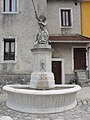
Fontaine au Dauphin fountain
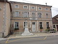
City Hall and Memorial to the Fallen

Memorial to the Fallen

Meuse and landscape near Chalaines


_fontaine.JPG)
_mairie.JPG)
_monument_aux_morts.JPG)

literature
- Le Patrimoine des Communes de la Meuse. Flohic Editions, Volume 2, Paris 1999, ISBN 2-84234-074-4 , pp. 1026-1029.
Web links
- Chalaines on the IGN side
- Village church Église de la Nativité de-la-Bienheureuse-Vierge-Marie
- Location of the place and brief information