Maizey
| Maizey | ||
|---|---|---|

|
|
|
| region | Grand Est | |
| Department | Meuse | |
| Arrondissement | Commercy | |
| Canton | Saint-Mihiel | |
| Community association | Sammiellois | |
| Coordinates | 48 ° 56 ' N , 5 ° 31' E | |
| height | 212-393 m | |
| surface | 14.91 km 2 | |
| Residents | 165 (January 1, 2017) | |
| Population density | 11 inhabitants / km 2 | |
| Post Code | 55300 | |
| INSEE code | 55312 | |
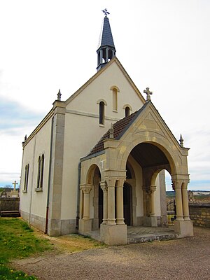
 Saint-Nicolas chapel |
||
Maizey is a French commune with 165 inhabitants (as of January 1, 2017) in the Meuse department in the Grand Est region (until 2015 Lorraine ); it belongs to the Arrondissement Commercy and the community association Sammiellois .
geography
Maizey is located around 53 kilometers southwest of Metz in the east of the Meuse department. The place is just west of the Lorraine Regional Nature Park . Large areas in the south of the municipality are forested (Fôret Domaniale de la Pitancerie). The place is between the Canal de la Meuse and the Meuse . The latter partially forms the municipal boundary. The community consists of the village of Maizey and a few individual farms.
Neighboring municipalities are Rouvrois-sur-Meuse and Lamorville in the north, Valbois in the northeast, Saint-Mihiel in the southeast, Chauvoncourt in the southwest and Les Paroches and Dompcevrin in the west.
history
Like all parishes in the area, the parish suffered from conflict in the Middle Ages. The worst devastation was caused by the Hundred Years War and the Thirty Years War . The name of the community was first mentioned in a document in 973 under the Latin name Mariscum . In the Middle Ages, today's community was in the Barrois non mouvant in the Duchy of Lorraine and belonged to the Bailliage Saint-Mihiel. From 1766 until the French Revolution , the community was in the Grand-gouvernement de Lorraine-et-Barrois . Maizey belonged to the District of Saint-Mihiel from 1793 to 1801 and was part of the canton of Lacroix. The municipality has been in the canton of Saint-Mihiel since 1801 and is assigned to the Arrondissement of Commercy. During the First World War, the place was almost completely destroyed.
Population development
The population development is typical for a French rural community. The development between 1793 and 1836 is normal with strong growth. Then the rural exodus began in the community. During the First World War, the place was completely destroyed. Therefore, in November 1918, not a single one of the former 266 residents lived in the municipality, as 110 of the 115 houses were completely destroyed. Some of the previous residents returned in the following years. Between 1926 and 1975, emigration continued until its low point in 1975. From the high of 1836 to 1975 the decrease was 72.4 percent. There was strong growth between 1975 and 1982 (1999–2011: +23.3 percent). In recent years the population has decreased again.
| year | 1793 | 1836 | 1911 | 1921 | 1926 | 1962 | 1968 | 1975 | 1982 | 1990 | 1999 | 2006 | 2011 | 2016 |
| Residents | 334 | 543 | 266 | 175 | 200 | 175 | 157 | 150 | 185 | 179 | 175 | 185 | 176 | 166 |
| Sources: Cassini and INSEE | ||||||||||||||
Attractions
- Village church of Saint-Étienne from 1925 (reconstruction of the destroyed village church)
- Saint-Nicolas chapel (also called Notre-Dame-des-Neiges ) by the village cemetery from the 18th century
- Sainte-Marie chapel in the south of the commune; rebuilt after the First World War
- Memorial to the Fallen
- three wayside crosses ( Croix au Loup near Ste. Marie, Croix Marchal on the D964 and on the D101 northwest of the village)
traffic
The community is on the D964. These and the D101 are the most important regional transport links for the municipality, which is far from the motorways.
Until the end of passenger traffic, the Lérouville – Pont-Maugis railway , which is now only used for goods traffic, passed west of the municipality. The next stop was Dompcevrin, 500 meters away. An application for resumption of passenger traffic has been submitted to the responsible ministry in Paris. However, this request has not yet been decided. Closest train stations are Lérouville and Commercy.
literature
- Le Patrimoine des Communes de la Meuse. Flohic Editions, Volume 2, Paris 1999, ISBN 2-84234-074-4 , pp. 817-818.
