
Houdelaincourt
| Houdelaincourt | ||
|---|---|---|

|
|
|
| region | Grand Est | |
| Department | Meuse | |
| Arrondissement | Commercy | |
| Canton | Ligny-en-Barrois | |
| Community association | Haute Saulx and Perthois-Val d'Ornois | |
| Coordinates | 48 ° 33 ' N , 5 ° 28' E | |
| height | 277-402 m | |
| surface | 16.07 km 2 | |
| Residents | 299 (January 1, 2017) | |
| Population density | 19 inhabitants / km 2 | |
| Post Code | 55130 | |
| INSEE code | 55248 | |

Houdelaincourt is a French commune with 299 inhabitants (as of January 1, 2017) in the Meuse department in the Grand Est region (before 2016 Lorraine ). It belongs to the Arrondissement Commercy and the Canton of Ligny-en-Barrois (until 2015 the Canton of Gondrecourt-le-Château ).
geography
The municipality is located about 34 kilometers southeast of Bar-le-Duc in the south of the Meuse department. The municipality consists of the place Houdelaincourt and is located on the Ornain and the Rhine-Marne Canal . Large parts of the west of the municipality are forested (called Grand Bois ). Neighboring municipalities are Baudignécourt in the north, Delouze-Rosières in the east, Abainville in the south-east, Bonnet in the south and south-west and Saint-Joire in the north-west.
history
The name of today's municipality was first mentioned in 982 as Hodelincurt in a document about Gérard de Toul. In the Middle Ages the community belonged to the Duchy of Bar and then to the Duchy of Lorraine . More precisely to the Office ( Bailliage ) Saint-Thiébaud. With this rule, Houdelaincourt fell to France in 1766. Until the French Revolution , the community was in the Grand-gouvernement de Lorraine-et-Barrois . From 1793 to 1801 the municipality was assigned to the Gondrecourt district and part of the Demange aux Eaux canton, then from 1801 to 2015 part of the Gondrecourt-le-Château canton. Since 1801 Houdelaincourt is assigned to the Arrondissement Commercy.
Population development
| year | 1793 | 1876 | 1936 | 1962 | 1968 | 1975 | 1982 | 1990 | 1999 | 2006 | 2011 | 2016 |
| Residents | 450 | 621 | 385 | 441 | 432 | 395 | 370 | 358 | 346 | 358 | 349 | 306 |
| Source: Cassini and INSEE | ||||||||||||
Attractions
- Saint-Pierre-ès-liens village church from the 16th century
- Notre-Dame-de-la-Consolation chapel from 1921
- Two wayside crosses; one in rue de la Maix west of the village and another wayside cross in rue de l'Église
- Two lavoirs (wash houses) within the village; the Fontaine-lavoir de plan demi-circulaire has been a monument historique since 1988
- Memorial to the Fallen

Notre-Dame-de-la-Consolation chapel
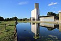
Rhine-Marne Canal and silo at Houdelaincourt

former lavoir of the community, today an MH


literature
- Le Patrimoine des Communes de la Meuse. Flohic Editions, Volume 1, Paris 1999, ISBN 2-84234-074-4 , p. 496.
Individual evidence
- ^ Name forms of the community
- ↑ Information on the population development and the political affiliation of the municipality
- ↑ Population 2006, 2011 and 2016
- ↑ moving sights
- ^ Fontaine-lavoir de plan demi-circulaire
- ↑ Memorial to the Fallen