
Burey-la-Cote
| Burey-la-Cote | ||
|---|---|---|

|
|
|
| region | Grand Est | |
| Department | Meuse | |
| Arrondissement | Commercy | |
| Canton | Vaucouleurs | |
| Community association | Commercy-Void-Vaucouleurs | |
| Coordinates | 48 ° 30 ' N , 5 ° 42' E | |
| height | 261-383 m | |
| surface | 4.29 km 2 | |
| Residents | 87 (January 1, 2017) | |
| Population density | 20 inhabitants / km 2 | |
| Post Code | 55140 | |
| INSEE code | 55089 | |
 Saint-Léger village church |
||

Burey-la-Côte is a French commune with 87 inhabitants (as of January 1, 2017) in the Meuse department in the Grand Est region (until 2015 Lorraine ); it belongs to the Arrondissement Commercy and the community association Communauté de communes de Commercy-Void-Vaucouleurs .
geography
Burey-la-Côte is located around 25 kilometers southwest of the city of Toul in the south of the Meuse department. In terms of traffic, the municipality is far away from national traffic routes near the D964. The place is west of the Meuse on the Ruisseau de Goussaincourt . The Bois de Burey-la-Côte forest area covers large parts of the western municipality.
Neighboring communities are Montbras in the north-west and north, Sauvigny in the east and south-east, Goussaincourt in the south and Taillancourt in the south-west.
history
Like all places in the area, Burey-la-Côte suffered from conflicts in the Middle Ages. The worst devastation was caused by the Hundred Years War and the Thirty Years War . The name of today's parish was first mentioned in a document in 1327 under the name Burey . In the Middle Ages the place belonged to the Bailliage Chaumont within the Champagne region . Until the French Revolution , the place was in the Grand-gouvernement de Lorraine-et-Barrois .
Burey-la-Côte belonged to the Gondrecourt district from 1793 to 1801. In addition to the canton of Goussaincourt from 1793 to 1801. The municipality has been assigned to the canton of Vaucouleurs and the Arrondissement of Commercy since 1801.
Population development
The parish shares the fate of many rural parishes in France. The population grew in the first half of the 19th century. This was followed by a rural exodus that greatly reduced the number of residents (1831–1990: −83.1 percent). The population has been growing again since 1990 (1990–2016: +69.2 percent).
| year | 1793 | 1831 | 1962 | 1968 | 1975 | 1982 | 1990 | 1999 | 2006 | 2011 | 2016 |
| Residents | 230 | 307 | 82 | 74 | 70 | 57 | 52 | 73 | 66 | 84 | 88 |
| Sources: Cassini and INSEE | |||||||||||
Attractions
- Saint-Léger village church
- Three wayside crosses near the village
- Memorial plaque for the fallen on the church wall
- Two wash houses ( lavoirs )
- Water tower
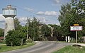
Burey-la-Côte water tower

Memorial plaque for the fallen


literature
- Le Patrimoine des Communes de la Meuse. Flohic Editions, Volume 2, Paris 1999, ISBN 2-84234-074-4 , pp. 1024-1025.
Web links
- Burey-la-Côte on the IGN side
- Saint-Léger village church
- Location of the place and brief information