
Taillancourt
| Taillancourt | ||
|---|---|---|

|
|
|
| region | Grand Est | |
| Department | Meuse | |
| Arrondissement | Commercy | |
| Canton | Vaucouleurs | |
| Community association | Commercy-Void-Vaucouleurs | |
| Coordinates | 48 ° 32 ' N , 5 ° 42' E | |
| height | 257-422 m | |
| surface | 11.09 km 2 | |
| Residents | 127 (January 1, 2017) | |
| Population density | 11 inhabitants / km 2 | |
| Post Code | 55140 | |
| INSEE code | 55503 | |
 View of Taillancourt |
||

Taillancourt is a French commune with 127 inhabitants (as of January 1, 2017) in the Meuse department in the Grand Est region (until 2015 Lorraine ); it belongs to the Arrondissement Commercy and the community association Communauté de communes de Commercy-Void-Vaucouleurs .
geography
Taillancourt is located around 40 kilometers west-southwest of Nancy in the south of the Meuse department. The place is on the Meuse . Large parts of the municipality are forested (Bois de Taillancourt).
Neighboring municipalities are Champougny in the north and northeast, Montbras in the east, Burey-la-Côte and Goussaincourt in the southeast, and south, Vouthon-Bas in the southwest, Amanty in the west and Maxey-sur-Vaise in the west and northwest.
history
Like all places in the area, Taillancourt suffered from conflict in the Middle Ages. The worst devastation was caused by the Hundred Years War and the Thirty Years War . The name of today's parish was first mentioned in a document in 1327 under the name Tallancourt . In the Middle Ages, today's municipality was within the Champagne region and belonged to the Bailliage Chaumont. From 1766 until the French Revolution , the community was in the Grand-gouvernement de Lorraine-et-Barrois . Taillancourt belonged to the District Gondrecourt from 1793 to 1801. From 1793 to 1801 it was part of the canton of Maxey sur Vaise. It has been in the canton of Vaucouleurs since 1801. The parish has been assigned to the Arrondissement of Commercy since 1801.
Population development
The parish shares the fate of many rural parishes in France. From 1840 the rural exodus begins. From the high in 1800 to the low in 1982, the number of residents decreased by 81.2 percent. In the last few decades the population has grown again strongly (1982–2016: +37.5 percent).
| year | 1793 | 1800 | 1841 | 1962 | 1968 | 1975 | 1982 | 1990 | 1999 | 2006 | 2011 | 2016 |
| Residents | 486 | 510 | 496 | 129 | 108 | 115 | 96 | 98 | 121 | 132 | 150 | 132 |
| Sources: Cassini and INSEE | ||||||||||||
Attractions
- Saint-Gengoult village church from 1760; Choir from 1840
- three village fountains and door portals on rue Delle
- Memorial to the Fallen
- Wash house (Lavoir) from the 18th century
- two wayside crosses in the village center and on the D964

Town hall (Mairie) of the municipality

Saint-Gengoult village church
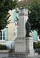
Memorial to the Fallen

Bridge over the Meuse


traffic
The community is located on the D964 far away from national traffic connections.
The closest train station is Pagny-sur-Meuse on the Paris – Strasbourg line , around 19 kilometers away.
literature
- Le Patrimoine des Communes de la Meuse. Flohic Editions, Volume 2, Paris 1999, ISBN 2-84234-074-4 , pp. 1054-1056.
Web links
- Taillancourt on the IGN side
- Saint-Gengoult village church
- Location of the place and brief information