
Pont-sur-Meuse
| Pont-sur-Meuse | ||
|---|---|---|

|
|
|
| region | Grand Est | |
| Department | Meuse | |
| Arrondissement | Commercy | |
| Canton | Commercy | |
| Community association | Commercy-Void-Vaucouleurs | |
| Coordinates | 48 ° 48 ' N , 5 ° 33' E | |
| height | 224-332 m | |
| surface | 3.63 km 2 | |
| Residents | 133 (January 1, 2017) | |
| Population density | 37 inhabitants / km 2 | |
| Post Code | 55200 | |
| INSEE code | 55407 | |
_mairie.JPG) Town hall (Mairie) of the municipality |
||

Pont-sur-Meuse is a French commune with 133 inhabitants (as of January 1, 2017) in the Meuse department in the Grand Est region (until 2015 Lorraine ); it belongs to the Arrondissement Commercy and the community association Communauté de communes de Commercy-Void-Vaucouleurs .
geography
Pont-sur-Meuse is located around 48 kilometers west-northwest of Nancy in the southern half of the Meuse department. The place is located on the Meuse in the far west of the Lorraine Regional Nature Park . In contrast to most of the municipalities in the region, only small parts of the municipality are forested.
Neighboring municipalities are Mécrin in the north-west and north, Apremont-la-Forêt in the north, Boncourt-sur-Meuse in the east and south-east, Lérouville in the south and Vadonville in the south-west and west.
history
Like all places in the area, Pont-sur-Meuse suffered from conflicts in the Middle Ages. The worst devastation was caused by the Hundred Years War and the Thirty Years War . The name of today's community was first mentioned in a document in 1106 under the name Pons . In the Middle Ages, today's community was in the Barrois non mouvant within the county of Apremont and belonged to the Bailliage Saint-Mihiel. From 1766 until the French Revolution , the community was in the Grand-gouvernement de Lorraine-et-Barrois . Pont-sur-Meuse belonged to the District of Commercy from 1793 to 1801. From 1793 to 1801 it was part of the canton of Vignot. It has been in the canton of Commercy since 1801 and is assigned to the Arrondissement of Commercy.
Population development
The population development is atypical for a French rural community. The development between 1793 and 1851 is normal with strong growth. Until the First World War there was no rural exodus from the community. Because of the war, the population fell sharply between 1911 and 1921. In 1962 the population was the same as it was in 1921. After a population decline since then, the population is now at a low point. From the peak in 1851 until today, the decrease was 52.1 percent.
| year | 1793 | 1851 | 1856 | 1876 | 1911 | 1921 | 1962 | 1968 | 1975 | 1982 | 1990 | 1999 | 2006 | 2011 | 2016 |
| Residents | 193 | 284 | 204 | 273 | 256 | 183 | 182 | 165 | 144 | 150 | 154 | 145 | 142 | 142 | 136 |
| Sources: Cassini and INSEE | |||||||||||||||
Attractions
- Saint-Gérard village church
- Memorial to the fallen in the village cemetery
- two wayside crosses on Rue Haute to the west and east of the village

Saint-Gérard village church
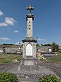
Memorial to the Fallen

Wayside cross on rue Haute
_%C3%A9glise_(01).JPG)
_monument_aux_morts_au_cimeti%C3%A8re.JPG)
_croix_de_chemin_Rue_Haute.JPG)
traffic
The community is located on the D12. The D964, which passes to the west, and the Route nationale 4 , which runs just a few kilometers to the south, with the next connection in Saulvaux, are the most important national transport links for the municipality.
The closest train station is Lérouville on the Paris – Strasbourg and Lérouville – Metz rail lines, less than a kilometer away.
literature
- Le Patrimoine des Communes de la Meuse. Flohic Editions, Volume 1, Paris 1999, ISBN 2-84234-074-4 , p. 308.
Web links
- Pont-sur-Meuse on the IGN side
- Saint-Gérard village church
- Location of the place and brief information