
Sepvigny
| Sepvigny | ||
|---|---|---|

|
|
|
| region | Grand Est | |
| Department | Meuse | |
| Arrondissement | Commercy | |
| Canton | Vaucouleurs | |
| Community association | Commercy-Void-Vaucouleurs | |
| Coordinates | 48 ° 33 ' N , 5 ° 41' E | |
| height | 252-382 m | |
| surface | 6.31 km 2 | |
| Residents | 74 (January 1, 2017) | |
| Population density | 12 inhabitants / km 2 | |
| Post Code | 55140 | |
| INSEE code | 55485 | |
.jpg) Partial view of the village |
||

Sepvigny is a French commune with 74 inhabitants (as of January 1, 2017) in the Meuse department in the Grand Est region ( Lorraine until 2015 ); it belongs to the Arrondissement Commercy and the community association Communauté de communes de Commercy-Void-Vaucouleurs .
geography
Sepvigny is located around 21 kilometers southwest of the city of Toul in the south of the Meuse department on the border with the Meurthe-et-Moselle department . In terms of traffic, the municipality is far away from national traffic routes near the D964. The place is on the Meuse . In contrast to many other municipalities in the region, Sepvigny is only sparsely forested.
Neighboring communities are Chalaines in the north, Gibeaumeix (in the department of Meurthe-et-Moselle) in the northeast, Uruffe (in the department of Meurthe-et-Moselle) in the east, Champougny in the southeast and south, Maxey-sur-Vaise in the southwest, Burey-en- Vaux in the west and Neuville-lès-Vaucouleurs in the north-west.
history
Like all places in the area, Sepvigny suffered from conflicts in the Middle Ages. The worst devastation was caused by the Hundred Years War and the Thirty Years War . The name of today's municipality was first mentioned in a document in 1051 under the Latin name Saviniacum . In the Middle Ages the community belonged to the Duchy of Bar and then to the Duchy of Lorraine . More precisely to the Bailliage Toul in the Barrois non mouvant . With this rule Sepvigny fell to France in 1766. Until the French Revolution , the community was in the Grand-gouvernement de Lorraine-et-Barrois . Sepvigny was part of the Gondrecourt district from 1793 to 1801. Also since 1793 to the canton of Vaucouleurs. The parish has been assigned to the Arrondissement of Commercy since 1801.
Population development
The parish shares the fate of many rural parishes in France. The population grew in the first half of the 19th century. This was followed by a rural exodus, which greatly reduced the number of residents (1856–1946: −72 percent). In the last few decades the population has continued to shrink to a lesser extent (1968–2016: −28.6 percent).
| year | 1793 | 1856 | 1906 | 1946 | 1962 | 1968 | 1975 | 1982 | 1990 | 1999 | 2006 | 2011 | 2016 |
| Residents | 270 | 346 | 174 | 97 | 102 | 105 | 94 | 73 | 85 | 81 | 81 | 79 | 75 |
| Sources: Cassini and INSEE | |||||||||||||
Attractions
- Fortified church of Saint-Évre (12th-14th centuries), monument historique since 1908
- Notre-Dame-des-Sept-Douleurs chapel (12th and 16th centuries) and cemetery in Vieux-Astre, monument historique since 1910
- 16th century stone cross on Rue de la Croix, Monument historique since 1909
- Memorial to the Fallen
- Wash house (lavoir)

Saint Èvre fortified church
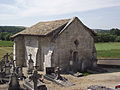
Chapel and cemetery
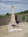
Memorial to the Fallen

Landscape near Sepvigny
.jpg)


.jpg)
literature
- Le Patrimoine des Communes de la Meuse. Flohic Editions, Volume 2, Paris 1999, ISBN 2-84234-074-4 , pp. 1052-1054.