
Vaudeville-le-Haut
| Vaudeville-le-Haut | ||
|---|---|---|

|
|
|
| region | Grand Est | |
| Department | Meuse | |
| Arrondissement | Commercy | |
| Canton | Ligny-en-Barrois | |
| Community association | Portes de Meuse | |
| Coordinates | 48 ° 27 ' N , 5 ° 36' E | |
| height | 300-451 m | |
| surface | 9.71 km 2 | |
| Residents | 55 (January 1, 2017) | |
| Population density | 6 inhabitants / km 2 | |
| Post Code | 55130 | |
| INSEE code | 55534 | |
 View of Vaudeville-le-Haut |
||

Vaudeville-le-Haut is a French commune with 55 inhabitants (as of January 1, 2017) in the Meuse department in the Grand Est region (until 2015 Lorraine ); it belongs to the Arrondissement Commercy and the municipality of Portes de Meuse . The community belonged to the canton of Gondrecourt-le-Château until 2015 . The residents call themselves Vaudevillois / Vaudevilloises .
geography
Vaudeville-le-Haut is located around 50 kilometers southwest of Nancy in the very south of the Meuse department on the border with the Vosges department . Large parts of the municipal area are forested (Bois de Baconvaux, Bois de Vaudeville, La Cumine).
Neighboring municipalities are Vouthon-Haut in the north, Les Roises in the east, Seraumont and Chermisey (both in the Vosges department) in the south, Avranville (in the Vosges department) in the south-west, Dainville-Bertheléville in the west and Gondrecourt-le-Château in the north-west.
history
Like all places in the area, Vaudeville-le-Haut suffered from conflicts in the Middle Ages. The worst devastation was caused by the Hundred Years War and the Thirty Years War . The name of today's municipality was first mentioned in a document in 965 under the name Woldesinguesilla / Woldesingesvilla . In the Middle Ages, the community belonged to the Barrois mouvant and was part of the Champagne . It was subordinate to the Kastlanei Bassigny in the Bailliage Chaumont. Vaudeville-le-Haut belonged to the Gondrecourt district from 1793 to 1801. From 1793 to 1801 it was in the canton of Goussaincourt. From 1801 to 2015, Vaudeville-le-Haut was part of the canton of Gondrecourt-le-Château . The parish has been assigned to the Arrondissement of Commercy since 1801.
Population development
Because of its remoteness, the rural exodus was pronounced, as in many small communities in France. The population shrank from the high in 1851 to 1982 by 81.4 percent. After a short growth phase between 1990 and 1999, a further decline followed in recent years.
| year | 1793 | 1851 | 1866 | 1962 | 1968 | 1975 | 1982 | 1990 | 1999 | 2006 | 2011 | 2016 |
| Residents | 271 | 279 | 262 | 57 | 64 | 53 | 52 | 52 | 54 | 65 | 66 | 56 |
| Sources: Cassini and INSEE | ||||||||||||
Attractions
- Saint-Pierre village church
- Memorial to the fallen in the village cemetery
- Wayside cross in the village center
- Wash house ( Lavoir ) east of the village
- former mill at Ruisseau du Moulin
- former cemetery for cholera victims

Town Hall (Mairie) of Culey
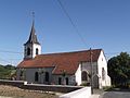
Saint-Pierre village church

Village entrance

former mill at Ruisseau du Moulin


traffic
The community is far away from national traffic routes. The D138 and the D164 are important for regional traffic.
The closest stop on a railway line is Neufchâteau in the Vosges department, around 12 kilometers away.
literature
- Le Patrimoine des Communes de la Meuse. Flohic Editions, Volume 1, Paris 1999, ISBN 2-84234-074-4 , pp. 502-503.
Web links
- Vaudeville-le-Haut on the IGN side
- Saint-Pierre village church
- Location of the place and brief information