
Boviolles
| Boviolles | ||
|---|---|---|

|
|
|
| region | Grand Est | |
| Department | Meuse | |
| Arrondissement | Commercy | |
| Canton | Vaucouleurs | |
| Community association | Commercy-Void-Vaucouleurs | |
| Coordinates | 48 ° 39 ′ N , 5 ° 25 ′ E | |
| height | 241-395 m | |
| surface | 8.13 km 2 | |
| Residents | 97 (January 1, 2017) | |
| Population density | 12 inhabitants / km 2 | |
| Post Code | 55500 | |
| INSEE code | 55067 | |
_mairie_et_croix_de_chemin.JPG) Town hall (Mairie) and wayside cross |
||

Boviolles is a French commune with 97 inhabitants (as of January 1, 2017) in the Meuse department in the Grand Est region (until 2015 Lorraine ); it belongs to the Arrondissement Commercy and the community association Communauté de communes de Commercy-Void-Vaucouleurs . The municipality belonged to the canton of Void-Vacon until 2015 .
geography
Boviolles is located around 23 kilometers southeast of the city of Bar-le-Duc in the south of the Meuse department. In terms of transport, the community is a few kilometers south of Route nationale 4 with the next connection in Void-Vacon. The place is on the river Barboure . Large parts of the municipality are forested (Le Chanois, Le Nouvellois and La Rippe).
Neighboring municipalities are Chanteraine in the north-west, Sauvoy in the north-east, Marson-sur-Barboure in the east and south-east, Tréveray and Saint-Amand-sur-Ornain in the south and Naix-aux-Forges in the west.
history
Remains of an oppidum and from Gallo-Roman times prove an early settlement.
Like all places in the area, Boviolles suffered from conflicts in the Middle Ages. The worst devastation was caused by the Hundred Years War and the Thirty Years War . The name of today's municipality was first mentioned in a document in 1135 under the name Boviola / Boviolta . In the Middle Ages the place belonged to the Barrois mouvant and was part of the Champagne .
Boviolles belonged to the District Commercy from 1793 to 1801. Also from 1793 to 1801 to the canton of Reffroy and from 1801 to 2015 to the canton of Void-Vacon. The parish has been assigned to the Arrondissement of Commercy since 1801.
Population development
| year | 1793 | 1831 | 1851 | 1896 | 1962 | 1968 | 1975 | 1982 | 1990 | 1999 | 2006 | 2011 | 2016 |
| Residents | 348 | 356 | 320 | 196 | 119 | 115 | 96 | 79 | 92 | 91 | 95 | 109 | 95 |
| Sources: Cassini and INSEE | |||||||||||||
Attractions
- Remains of an oppidum
- Fortified church Église de la Nativité with nave from the 15th century
- Rectory
- Village fountain in the center of the village
- Memorial to the Fallen
- Several wayside crosses around the village
- Houses from the 17th to 19th centuries
- Former mill in La Barboure
- Wash house ( lavoir )

Remains of a temple from Gallo-Roman times

Fortified church Église de la Nativité

Village fountain and town center

crossroads
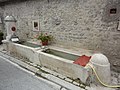
one of the village fountains
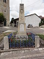
Memorial to the Fallen

Wash house (lavoir)
.jpg)
_%C3%A9glise_de_la_Nativit%C3%A9-de-la-Sainte-Vierge_(02).JPG)
_fontaine_centre-bourg.JPG)
_croix_de_chemin_B.JPG)
_fontaine_avec_petit_lavoir.JPG)
_monument_aux_morts.JPG)
_lavoir_(01).JPG)
literature
- Le Patrimoine des Communes de la Meuse. Flohic Editions, Volume 2, Paris 1999, ISBN 2-84234-074-4 , pp. 1222-1223.
Web links
- Boviolles on the IGN side
- Village church Église de la Nativité
- Location of the place and brief information