
Champougny
| Champougny | ||
|---|---|---|

|
|
|
| region | Grand Est | |
| Department | Meuse | |
| Arrondissement | Commercy | |
| Canton | Vaucouleurs | |
| Community association | Commercy-Void-Vaucouleurs | |
| Coordinates | 48 ° 33 ' N , 5 ° 42' E | |
| height | 254-383 m | |
| surface | 5.91 km 2 | |
| Residents | 83 (January 1, 2017) | |
| Population density | 14 inhabitants / km 2 | |
| Post Code | 55140 | |
| INSEE code | 55100 | |
 Saint-Brice fortified church |
||

Champougny is a French commune with 83 inhabitants (as of January 1, 2017) in the Meuse department in the Grand Est region (until 2015 Lorraine ); it belongs to the Arrondissement Commercy and the community association Communauté de communes de Commercy-Void-Vaucouleurs .
geography
Champougny is located around 21 kilometers southwest of the city of Toul in the south of the Meuse department on the border with the Meurthe-et-Moselle department . In terms of traffic, the municipality is far away from national traffic routes near the D964. The place is on the Meuse . In contrast to many other municipalities in the region, Champougny is only sparsely forested.
Neighboring municipalities are Sepvigny in the north, Uruffe (in the Meurthe-et-Moselle department) in the northeast, Pagny-la-Blanche-Côte in the east, Montbras in the southeast, Taillancourt in the south and Maxey-sur-Vaise in the west.
history
Like all places in the area, Champougny suffered from conflicts in the Middle Ages. The worst devastation was caused by the Hundred Years War and the Thirty Years War . The name of today's community was first mentioned in a document in 650 under the Latin name Camponiacum . In the Middle Ages, the place belonged to the area of the Duchy of Bar and then to the Duchy of Lorraine . More precisely to the Bailliage Toul in the Barrois non mouvant . With this rule Champougny fell to France in 1766. Until the French Revolution , the place was in the Grand-gouvernement de Lorraine-et-Barrois .
Champougny belonged to the Gondrecourt district from 1793 to 1801. Also since 1793 to the canton of Vaucouleurs. The parish has been assigned to the Arrondissement of Commercy since 1801.
Population development
The parish shares the fate of many rural parishes in France. The population grew in the first half of the 19th century. This was followed by rural exodus, which greatly reduced the number of residents (1891–1990: −74.5 percent). In the last decades the population has grown again strongly (1990–2011: +115.7 percent).
| year | 1793 | 1836 | 1891 | 1962 | 1968 | 1975 | 1982 | 1990 | 1999 | 2006 | 2011 | 2016 |
| Residents | 216 | 248 | 200 | 92 | 84 | 67 | 57 | 51 | 80 | 100 | 110 | 93 |
| Sources: Cassini and INSEE | ||||||||||||
Attractions
- Saint-Brice fortified church
- Chapel Notre-Dame des Afflicted ; Origins in the Middle Ages, today's chapel from the 17th century
- Former fortress Fort de Pagny-la-Blanche-Côte
- Commemorative plaque for the fallen
- z´Two wash houses ( lavoirs )
- Crossroads on the D145 towards Sepvigny
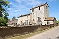
Saint-Brice fortified church

Notre-Dame-des-Affligés chapel

Champougny wash-house


literature
- Le Patrimoine des Communes de la Meuse. Flohic Editions, Volume 2, Paris 1999, ISBN 2-84234-074-4 , pp. 1029-1031.