
Baudrémont
| Baudrémont | ||
|---|---|---|

|
|
|
| region | Grand Est | |
| Department | Meuse | |
| Arrondissement | Commercy | |
| Canton | Dieue-sur-Meuse | |
| Community association | Aire à l'Argonne | |
| Coordinates | 48 ° 50 ' N , 5 ° 23' E | |
| height | 268-352 m | |
| surface | 6.81 km 2 | |
| Residents | 50 (January 1, 2017) | |
| Population density | 7 inhabitants / km 2 | |
| Post Code | 55260 | |
| INSEE code | 55032 | |

Baudrémont is a French commune with 50 inhabitants (as of January 1, 2017) in the Meuse department in the Grand Est region (before 2016 Lorraine ). It belongs to the Arrondissement Commercy and the canton Dieue-sur-Meuse (until 2015 the canton Pierrefitte-sur-Aire ).
geography
The municipality is located about 18 kilometers northeast of Bar-le-Duc in the center of the Meuse an der Aire department . The municipality consists only of the place Baudrémont. Large parts of the community east of the village are forested. The most important forest area is called Bois de Baudrémont . Neighboring municipalities are Gimécourt in the north-west and north, Kœur-la-Petite in the north-east and east, Courcelles-en-Barrois in the south-east, Lignières-sur-Aire in the south and Levoncourt in the south and south-west.
history
The name of today's municipality was first mentioned in a document in 709 under the Latin name Baudemotrovilla . In the Middle Ages, the place belonged to the area of the Duchy of Bar and then to the Duchy of Lorraine . More precisely to the Amt ( Bailliage ) Bar. With this rule, Baudrémont fell to France in 1766. Until the French Revolution , the community was in the Grand-gouvernement de Lorraine-et-Barrois . From 1793 to 1801 the municipality was assigned to the Saint-Mihiel district and part of the canton of Sampigny. And from 1801 to 2015 part of the canton of Pierrefitte-sur-Aire. Since 1801, Baudrémont has been assigned to the Arrondissement of Commercy.
Population development
| year | 1793 | 1800 | 1806 | 1841 | 1936 | 1962 | 1968 | 1975 | 1982 | 1990 | 1999 | 2006 | 2011 | 2016 |
| Residents | 97 | 297 | 311 | 288 | 72 | 75 | 54 | 56 | 50 | 48 | 50 | 47 | 54 | 52 |
| Source: Cassini (censuses up to 1999) and INSEE (official estimates as of January 1 from 2006) | ||||||||||||||
Attractions
- Saint Didier village church
- Fallen memorial
- Wayside cross west of the village

Town hall (Mairie) of Baudrémont
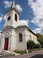
Saint Didier village church

Interior of the church

crossroads
Fallen memorial

Lemaire water pump

Éternel bridge over the Aire
_mairie.jpg)
.jpg)
.jpg)
_croix_de_chemin.jpg)

_pompe_Lemaire_A.jpg)
_pont_%C3%A9ternel.jpg)
literature
- Le Patrimoine des Communes de la Meuse. Flohic Editions, Volume 2, Paris 1999, ISBN 2-84234-074-4 , p. 736.
Individual evidence
- ^ Name forms of the community
- ↑ Information on the population development and the political affiliation of the municipality
- ↑ Population 2006, 2011 and 2016