
Vadonville
| Vadonville | ||
|---|---|---|

|
|
|
| region | Grand Est | |
| Department | Meuse | |
| Arrondissement | Commercy | |
| Canton | Commercy | |
| Community association | Commercy-Void-Vaucouleurs | |
| Coordinates | 48 ° 48 ' N , 5 ° 32' E | |
| height | 224-326 m | |
| surface | 5.21 km 2 | |
| Residents | 260 (January 1, 2017) | |
| Population density | 50 inhabitants / km 2 | |
| Post Code | 55200 | |
| INSEE code | 55526 | |
_%C3%A9glise_(01).jpg) Vadonville village church |
||

Vadonville is a French commune with 260 inhabitants (as of January 1, 2017) in the Meuse department in the Grand Est region ( Lorraine until 2015 ); it belongs to the Arrondissement Commercy and the community association Communauté de communes de Commercy-Void-Vaucouleurs .
geography
Vadonville is located around 50 kilometers west-northwest of Nancy in the southern half of the Meuse department. The place is near the Meuse on the Canal de la Meuse just west of the Lorraine Regional Nature Park . Large parts of the west of the municipality are forested (Bois Beaula, Bois de Vadonville, Gros Bois and La Haie).
Neighboring municipalities are Sampigny in the northwest and north, Mécrin in the northeast, Pont-sur-Meuse in the east, Lérouville in the southeast, Chonville-Malaumont in the south and southwest and Grimaucourt-près-Sampigny in the west.
history
Like all places in the area, Vadonville suffered from conflict in the Middle Ages. The worst devastation was caused by the Hundred Years War and the Thirty Years War . The name of today's parish was first mentioned in a document in 1106 under the Latin name Vodonis-villa . In the Middle Ages, today's community was in the Barrois mouvant within Champagne and belonged to the Bailliage Saint-Mihiel. From 1766 until the French Revolution , the community was in the Grand-gouvernement de Lorraine-et-Barrois . Vadonville was part of the District Commercy from 1793 to 1801. From 1793 to 1801 it was part of the Canton of Dagonville. It has been in the canton of Commercy since 1801 and is assigned to the Arrondissement of Commercy.
Population development
The population development is atypical for a French rural community. The developments between 1793 and 1851 are normal with strong growth and the subsequent strong rural exodus until 1872. However, the number of inhabitants grew again after that and in 1926 was only slightly below the high of 1851. Between 1926 and 1975 there was another wave of emigration. Since then, the population has stabilized and is now higher than it was in 1793.
| year | 1793 | 1851 | 1872 | 1926 | 1962 | 1968 | 1975 | 1982 | 1990 | 1999 | 2006 | 2011 | 2016 |
| Residents | 217 | 435 | 326 | 431 | 308 | 329 | 253 | 278 | 261 | 239 | 249 | 260 | 261 |
| Sources: Cassini and INSEE | |||||||||||||
Attractions
- Village church Église de la Nativité de-la-Bienheureuse-Vierge-Marie
- Memorial to the Fallen
- Wash house (Lavoir) on the Route de Grimaucourt
- two wayside crosses in the rue de la Voie du Bois and in the village cemetery

Town hall (Mairie) of the municipality

Village church Église de la Nativité de-la-Bienheureuse-Vierge-Marie
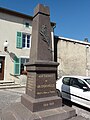
Memorial to the Fallen
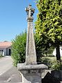
crossroads
_mairie.jpg)
_%C3%A9glise_(02).jpg)
_monument_aux_morts.jpg)
_croix_de_chemin.jpg)
traffic
The community is located on the D964. The national route 4 , which runs just a few kilometers to the south with the next connection in Saulvaux, is the most important supraregional transport connection for the municipality.
The closest train station is Lérouville on the Paris – Strasbourg and Lérouville – Metz lines , around one kilometer away.
literature
- Le Patrimoine des Communes de la Meuse. Flohic Editions, Volume 1, Paris 1999, ISBN 2-84234-074-4 , pp. 311-312.
Web links
- Vadonville on the IGN side
- Village church Église de la Nativité de-la-Bienheureuse-Vierge-Marie
- Location of the place and brief information