
Maxey-sur-Vaise
| Maxey-sur-Vaise | ||
|---|---|---|
.svg)
|
|
|
| region | Grand Est | |
| Department | Meuse | |
| Arrondissement | Commercy | |
| Canton | Vaucouleurs | |
| Community association | Commercy-Void-Vaucouleurs | |
| Coordinates | 48 ° 32 ' N , 5 ° 40' E | |
| height | 252-409 m | |
| surface | 10.90 km 2 | |
| Residents | 293 (January 1, 2017) | |
| Population density | 27 inhabitants / km 2 | |
| Post Code | 55140 | |
| INSEE code | 55328 | |
 Town hall ( Mairie ) of Maxey-sur-Vaise |
||

Maxey-sur-Vaise is a French commune with 293 inhabitants (as of January 1, 2017) in the Meuse department in the Grand Est region . It belongs to the Arrondissement of Commercy , the canton of Vaucouleurs and the municipality of Commercy-Void-Vaucouleurs .
geography
Maxey-sur-Vaise is surrounded by the neighboring communities of Épiez-sur-Meuse in the north-west, Burey-en-Vaux and Sepvigny in the north, Champougny in the north-east, Taillancourt in the east and south and by the community of Amanty in the canton of Ligny-en-Barrois in the West.
Population development
| year | 1962 | 1968 | 1975 | 1982 | 1990 | 1999 | 2006 | 2012 | 2016 |
| Residents | 372 | 373 | 355 | 330 | 293 | 328 | 310 | 314 | 302 |
| Source: Cassini and INSEE | |||||||||
Attractions
- Saint-Pierre-Saint-Paul church, built in the 18th century, destroyed in 1790, reconstructed in the 19th century
- Notre-Dame-de-Grâce chapel, built in the 18th century
- Cenotaph for the fallen soldiers of the First World War

Saint-Pierre-Saint-Paul Church
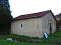
Notre-Dame-de-Grâce chapel

cenotaph


literature
- Le Patrimoine des Communes de la Meuse. Flohic Editions, Volume 2, Paris 1999, ISBN 2-84234-074-4 , pp. 1035-1037.
Web links
Commons : Maxey-sur-Vaise - Collection of images, videos and audio files