
Frémeréville-sous-les-Côtes
| Frémeréville-sous-les-Côtes | ||
|---|---|---|

|
|
|
| region | Grand Est | |
| Department | Meuse | |
| Arrondissement | Commercy | |
| Canton | Commercy | |
| Community association | Commercy-Void-Vaucouleurs | |
| Coordinates | 48 ° 48 ' N , 5 ° 39' E | |
| height | 233-375 m | |
| surface | 6.44 km 2 | |
| Residents | 137 (January 1, 2017) | |
| Population density | 21 inhabitants / km 2 | |
| Post Code | 55200 | |
| INSEE code | 55196 | |
 Village center of the municipality |
||

Frémeréville-sous-les-Côtes is a French commune with 137 inhabitants (as of January 1, 2017) in the Meuse department in the Grand Est region (until 2015 Lorraine ); it belongs to the Arrondissement Commercy and the community association Communauté de communes de Commercy-Void-Vaucouleurs .
geography
Frémeréville-sous-les-Côtes is located around 40 kilometers west-northwest of Nancy in the east of the Meuse department. The place is located in the far west of the Lorraine Regional Nature Park . The south of the communities is wooded (maringue).
Neighboring communities are Apremont-la-Forêt in the north, Broussey-Raulecourt in the north-east, Geville in the east and south-east, Vignot in the south and south-west and Girauvoisin in the west.
history
The name of today's community was first mentioned in a document in 1106 under the name Framea-villa . Like all places in the area, Frémeréville-sous-les-Côtes suffered from conflicts in the Middle Ages. The worst devastation was caused by the Hundred Years War and the Thirty Years War . In the Middle Ages, the place was in the Barrois mouvant in the Duchy of Lorraine and belonged to the Bailliage Saint-Mihiel. From 1766 until the French Revolution , the place was in the Grand-gouvernement de Lorraine-et-Barrois .
Frémeréville-sous-les-Côtes belonged to the District of Commercy from 1793 to 1801. From 1793 to 1801 it was part of the canton of Vignot. It has been in the canton of Commercy since 1801 and is assigned to the Arrondissement of Commercy. Until 1924 the municipality name was Frémeréville, without today's addition.
Population development
The population development is atypical for a French rural community. The development between 1793 and 1851 is normal with strong growth. From 1876 the rural exodus began in the community. Because of the war, the population fell sharply between 1911 and 1921. After a further decline in population, the number of inhabitants fell to a low point by 1982. From the high in 1841 to 1982 the decrease was 77.6 percent. Since then, the population has doubled (1982-2016: +104.2 percent).
| year | 1793 | 1841 | 1876 | 1911 | 1921 | 1962 | 1968 | 1975 | 1982 | 1990 | 1999 | 2006 | 2011 | 2016 |
| Residents | 244 | 317 | 295 | 169 | 120 | 103 | 81 | 78 | 71 | 77 | 75 | 95 | 119 | 145 |
| Sources: Cassini and INSEE | ||||||||||||||
Attractions
- Saint-Etienne village church
- Memorial to the Fallen
- Wash house ( Lavoir ) by the church
- several wayside crosses (on the Rue Haute, on the D130 east of the village and on the D958)

Saint-Etienne village church and wash house
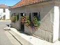
Wash house (Lavoir) by the church

Village fountain

Stained glass window of the Saint-Étienne church


traffic
The community is located on the D130. The D958, which passes to the west, and the Route nationale 4 , which runs just a few kilometers to the south, with the next connection in Void-Vacon, are the most important national transport links for the municipality.
The closest train station is Commercy on the Paris – Strasbourg line , around six kilometers away. The Lérouville – Metz railway passes in the north of the municipality . The closest train station on this line is Lérouville. All other stops between Lérouville and Onville have been canceled.
literature
- Le Patrimoine des Communes de la Meuse. Flohic Editions, Volume 1, Paris 1999, ISBN 2-84234-074-4 , p. 297.
Web links
- Frémeréville-sous-les-Côtes on the IGN side
- Saint-Etienne village church
- Location of the place and brief information