
Les Paroches
| Les Paroches | ||
|---|---|---|

|
|
|
| region | Grand Est | |
| Department | Meuse | |
| Arrondissement | Commercy | |
| Canton | Saint-Mihiel | |
| Community association | Sammiellois | |
| Coordinates | 48 ° 55 ' N , 5 ° 31' E | |
| height | 212-339 m | |
| surface | 10.24 km 2 | |
| Residents | 416 (January 1, 2017) | |
| Population density | 41 inhabitants / km 2 | |
| Post Code | 55300 | |
| INSEE code | 55401 | |
_mairie.JPG) Mairie (Town Hall) from Les Paroches |
||

Les Paroches is a French commune with 416 inhabitants (as of January 1, 2017) in the Meuse department in the Grand Est region ( Lorraine until 2015 ); it belongs to the Arrondissement Commercy and to the community association Communauté de communes du Sammiellois .
geography
Les Paroches is located around 54 kilometers southwest of the city of Metz in the east of the Meuse department. In terms of traffic, the community is far away from the motorways on the D34. The Meuse partially forms the eastern border of the municipality, which is extensively forested (Bois des Paroches).
history
During the First World War, the community was partially destroyed by acts of war. The Refricourt district was completely wiped out. Les Paroches was part of the Saint Mihiel district from 1793 to 1801. In addition, from 1793 to 1801 to the canton of Dompcevin and from 1801 to the canton of Saint-Mihiel. The parish has been assigned to the Arrondissement of Commercy since 1801.
Population development
| year | 1793 | 1836 | 1881 | 1911 | 1921 | 1926 | 1962 | 1968 | 1975 | 1982 | 1990 | 1999 | 2006 | 2014 |
| Residents | 356 | 490 | 385 | 404 | 186 | 227 | 243 | 209 | 256 | 308 | 345 | 358 | 351 | 417 |
| Sources: Cassini and INSEE | ||||||||||||||
Attractions
- Village church L'Assomption from the 16th century (renovated in 1925)
- Chapel of Our Lady of Refroicourt 19th century
- Memorial to the Fallen
- Wayside cross on the main street

L'Assomption village church

House chapel
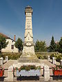
Memorial to the Fallen

crossroads
_%C3%89glise_de_l%27Invention-de-Saint-%C3%89tienne_ext%C3%A9rieur_(01).JPG)
_oratoire,_ext%C3%A9rieur.JPG)
_monument_aux_morts_(01).JPG)
_croix_de_chemin.JPG)
literature
- Le Patrimoine des Communes de la Meuse. Flohic Editions, Volume 2, Paris 1999, ISBN 2-84234-074-4 , p. 821.