
Ugny-sur-Meuse
| Ugny-sur-Meuse | ||
|---|---|---|

|
|
|
| region | Grand Est | |
| Department | Meuse | |
| Arrondissement | Commercy | |
| Canton | Vaucouleurs | |
| Community association | Commercy-Void-Vaucouleurs | |
| Coordinates | 48 ° 38 ' N , 5 ° 42' E | |
| height | 248-302 m | |
| surface | 4.29 km 2 | |
| Residents | 109 (January 1, 2017) | |
| Population density | 25 inhabitants / km 2 | |
| Post Code | 55140 | |
| INSEE code | 55522 | |
_mairie.JPG) Town hall ( Mairie ) of Ugny-sur-Meuse |
||

Ugny-sur-Meuse is a French commune with 109 inhabitants (as of January 1, 2017) in the Meuse department in the Grand Est region (until 2015 Champagne-Ardenne ). The municipality belongs to the Arrondissement Commercy and to the municipality association Commercy-Void-Vaucouleurss founded in 2016 .
geography
_city_limit_sign_and_Meuse_bridge.JPG)

The municipality of Ugny-sur-Meuse is located on the Meuse , about 13 kilometers west of Toul and 18 kilometers southeast of Commercy . The almost forest-free municipal area, only 4.29 km², is enclosed by a large horseshoe-shaped arch of the Meuse, which forms the municipal boundary in the north, east and south. The terrain rises gradually to the southwest and reaches the highest point in the municipality at 302 m above sea level in the district of L'Enfer near a former quarry. Ugny-sur-Meuse is surrounded by the neighboring communities of Saint-Germain-sur-Meuse in the north and northeast, Rigny-la-Salle in the southeast and south, and Vaucouleurs in the southwest and west.
Place name
The name Ugny is probably derived from the Germanic name Unno or Hunno (from the Old Norse hunn = bear ). The place name appeared for the first time in 1011 as Unniacum . The name developed over Ugney (1300), Ugneyum-prope-Valiscolorem (1402), Vgny (1700), Ugni (1707) and Unniacus or Hugny (1711) to the name Ugny when the community was founded in 1793. It was not until 1919 that Ugny received the suffix -sur-Meuse to distinguish it from other communities of the same name .
Population development
| year | 1962 | 1968 | 1975 | 1982 | 1990 | 1999 | 2007 | 2016 |
| Residents | 165 | 142 | 106 | 117 | 119 | 119 | 106 | 108 |
| Sources: Cassini and INSEE | ||||||||
Attractions
- Parish church of Saint-Loup from the 12th century, Monument historique
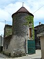
- Two pigeon towers, with a square and a round tower
- Several wells
- Remnants of an old wash house ( Lavoir )
- Seven war graves from the Second World War: crew of an English military aircraft, an Avro Lancaster , which was shot down by German anti-aircraft cartillery on April 27, 1944
- Two wayside crosses
- Fallen memorial

Saint-Loup church

Square pigeon tower
Round pigeon tower
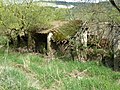
Ruins of the wash house
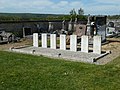
War graves

crossroads

Fallen memorial


_croix_de_chemin.JPG)
_monument_aux_morts_(03).JPG)
Economy and Infrastructure
Seven farms are located in the municipality of Ugny-sur-Meuse (cereal and vegetable growing, cattle breeding).
The Ogny-sur-Meuse stop on the Bologne – Pagny-sur-Meuse railway line was in operation for almost 100 years until passenger transport was discontinued in 1970. A large part of the track system has now been dismantled.
- Former route of the railway line in the municipality of Ugny-sur-Meuse


_ancien_chemin_de_fer_(02)_entre_rochers.JPG)
_ancien_chemin_de_fer_(05)_sous_viaduc_carr%C3%A9.JPG)

_ancien_chemin_de_fer_(06)_viaduc_4_arcs.JPG)
By Ugny-sur-Meuse which the leads Maas -turns following highway D 36 of Vaucouleurs to Pagny-sur-Meuse . In Pagny-sur-Meuse, seven kilometers away, there is a connection to the motorway-like RN 4 from Saint-Dizier to Toul .
literature
- Le Patrimoine des Communes de la Meuse. Flohic Editions, Volume 2, Paris 1999, ISBN 2-84234-074-4 , pp. 1056-1058.
supporting documents
- ↑ toponym on cassini.ehess.fr
- ↑ Ugny-sur-Meuse on cassini.ehess.fr (French)
- ↑ Ugny-sur-Meuse on INSEE
- ↑ Parish Church of Saint-Loup in the Base Mérimée of the French Ministry of Culture (French)
- ↑ Farms on annuaire-mairie.fr (French)