
Bannoncourt
| Bannoncourt | ||
|---|---|---|

|
|
|
| region | Grand Est | |
| Department | Meuse | |
| Arrondissement | Commercy | |
| Canton | Dieue-sur-Meuse | |
| Community association | Sammiellois | |
| Coordinates | 48 ° 58 ′ N , 5 ° 30 ′ E | |
| height | 210-329 m | |
| surface | 8.72 km 2 | |
| Residents | 155 (January 1, 2017) | |
| Population density | 18 inhabitants / km 2 | |
| Post Code | 55300 | |
| INSEE code | 55027 | |
 View of Bannoncourt |
||

Bannoncourt is a French commune with 155 inhabitants (as of January 1, 2017) in the Meuse department in the Grand Est region (before 2016 Lorraine ). It belongs to the Arrondissement Commercy and the canton Dieue-sur-Meuse (until 2015 the canton Pierrefitte-sur-Aire ). The inhabitants call themselves Bannoncourtois / Bannoncourtoises .
geography
The municipality is located about 32 kilometers northeast of Bar-le-Duc in the south of the Meuse department. The municipality consists of the town of Bannoncourt and is located on the Meuse and near the Maas Canal . Large parts of the west of the municipality are forested (called Bois de Bannoncourt ). Neighboring municipalities are Lacroix-sur-Meuse in the north-east and east, Rouvrois-sur-Meuse in the east and south-east, Maizey in the south-east, Dompcevrin in the south, Lahaymeix in the south-west and Woimbey in the west and north-west.
history
Finds from 2009 show early settlement in pre-Christian and Gallo-Roman times. The name of today's community was first mentioned in 815 as Banonocurtis in a document from Ludwig the Pious . In the Middle Ages, the place belonged to the area of the Duchy of Bar and then to the Duchy of Lorraine . More precisely to the Office ( Bailliage ) Saint-Mihiel. With this rule, Bannoncourt fell to France in 1766. Until the French Revolution , the community was in the Grand-gouvernement de Lorraine-et-Barrois . From 1793 to 1801 the municipality was assigned to the district of Saint-Mihiel and part of the canton of Dompcevin, then from 1801 to 2015 part of the canton of Pierrefitte-sur-Aire. Since 1801 Bannoncourt has been assigned to the Arrondissement of Commercy.
Population development
| year | 1793 | 1821 | 1846 | 1881 | 1962 | 1968 | 1975 | 1982 | 1990 | 1999 | 2006 | 2011 | 2016 |
| Residents | 343 | 383 | 385 | 375 | 166 | 165 | 155 | 151 | 163 | 195 | 182 | 172 | 153 |
| Source: Cassini and INSEE | |||||||||||||
Attractions
- Bridge Pont de Bannoncourt ; destroyed in World War I and rebuilt between 1920 and 1930
- Saint-Nicolas village church ; rebuilt after the First World War
- three wayside crosses: Croix du Poteau , Croix du Grand Pont and the village cemetery
- a stele with an inscription at the village cemetery
- Viaduc de la Meuse railway viaduct ; built from 2002
- Memorial to the Fallen
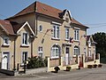
Town Hall (Mairie) of Bannoncourt

Saint-Nicolas church
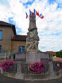
Memorial to the Fallen

Wayside cross south of the village

Pont de Bannoncourt

Railway viaduct over the Meuse

Landscape on the Little Maas
_mairie.JPG)


_croix_de_chemin_sud.JPG)


literature
- Le Patrimoine des Communes de la Meuse. Flohic Editions, Volume 2, Paris 1999, ISBN 2-84234-074-4 , p. 735.
Individual evidence
- ^ Name forms of the community
- ↑ Information on the population development and the political affiliation of the municipality
- ↑ Population 2006, 2011 and 2016
- ↑ Memorial to the Fallen