
Rigny-la-Salle
| Rigny-la-Salle | ||
|---|---|---|

|
|
|
| region | Grand Est | |
| Department | Meuse | |
| Arrondissement | Commercy | |
| Canton | Vaucouleurs | |
| Community association | Commercy-Void-Vaucouleurs | |
| Coordinates | 48 ° 37 ' N , 5 ° 42' E | |
| height | 242-392 m | |
| surface | 10.28 km 2 | |
| Residents | 365 (January 1, 2017) | |
| Population density | 36 inhabitants / km 2 | |
| Post Code | 55140 | |
| INSEE code | 55433 | |
_vue_du_village.JPG) View of the village |
||

Rigny-la-Salle is a French commune with 365 inhabitants (as of January 1, 2017) in the Meuse department in the Grand Est region ( Lorraine until 2015 ); it belongs to the Arrondissement Commercy and the community association Communauté de communes de Commercy-Void-Vaucouleurs .
geography
Rigny-la-Salle is located around 16 kilometers southwest of the small town of Toul in the south of the Meuse department on the border with the Meurthe-et-Moselle department . In terms of traffic, the municipality is not located on supraregional traffic routes. The nearby D964 and the route nationale 4 running a few kilometers to the north with the next connection in Pagny-sur-Meuse are the most important transport links for the municipality. The place is on the Ruisseau de Beaumelle near the Meuse , which in parts forms the western municipal boundary. Large parts of the east of the municipality are wooded (Bois de Rigny-la-Salle). The community consists of the now merged villages of Rigny-la-Salle and La Petite Fin and a few individual farms.
Neighboring municipalities are Saint-Germain-sur-Meuse in the north, Foug (in the Meurthe-et-Moselle department) in the northeast, Choloy-Ménillot (in the Meurthe-et-Moselle department) in the east, Rigny-Saint-Martin in the south, Chalaines in the Southwest, Vaucouleurs in the west and Ugny-sur-Meuse in the northwest.
history
Like all places in the area, Rigny-la-Salle suffered from conflicts in the Middle Ages. The worst devastation was caused by the Hundred Years War and the Thirty Years War . The name of today's municipality was first mentioned in a document in 971 under the Latin name Rigneium . In the Middle Ages the community belonged to the Barrois mouvant and was within the Champagne region . Rigny-la-Salle was part of the Bailliage Chaumont. Until the French Revolution , the community was in the Grand-gouvernement de Lorraine-et-Barrois . Rigny-la-Salle belonged to the Gondrecourt district from 1793 to 1801. Also since 1793 to the canton of Vaucouleurs. The parish has been assigned to the Arrondissement of Commercy since 1801.
Population development
The parish shares the fate of many rural parishes in France. In the first half of the 19th century the population was always more than 700 people. From 1876 there was a rural exodus, which greatly reduced the number of residents (1876–1990: −52.8 percent). The population has grown again in the last few decades.
| year | 1793 | 1836 | 1876 | 1962 | 1968 | 1975 | 1982 | 1990 | 1999 | 2006 | 2011 | 2016 |
| Residents | 625 | 826 | 640 | 405 | 409 | 397 | 332 | 302 | 323 | 365 | 398 | 368 |
| Sources: Cassini and INSEE | ||||||||||||
Attractions
The Château de Malpierre , which burned down in 1831 , is to be rebuilt over the next few years.
- Village church Église de la Nativité de-la-Vierge from 1834
- Calvary
- Town hall (Mairie) of the municipality
- Memorial to the fallen in front of the town hall
- Memorial to the fallen in the village cemetery
- Military graves for those killed in World War II in the village cemetery
- two wayside crosses north and east of the village
- Wash house (Lavoir) north of Rigny-la-Salle
- Source La Bonne Vierge in the Bois de Rigny-la-Salle

Village church Église de la Nativité de-la-Vierge

Calvary

City Hall and Memorial to the Fallen

Memorial to the Fallen
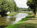
Ruisseau de Beaumelle and landscape near Rigny-la-Salle

Relief on a house wall

_calvaire.JPG)
_mairie.JPG)
_monument_aux_morts_(01).JPG)
_Aroffe_(Ruisseau_de_la_Beaumelle)_(01).JPG)
_relief_labor_sanitas_sur_une_maison.JPG)
literature
- Le Patrimoine des Communes de la Meuse. Flohic Editions, Volume 2, Paris 1999, ISBN 2-84234-074-4 , pp. 1044-1045.
Web links
- Rigny-la-Salle on the IGN side
- Village church Église de la Nativité de-la-Vierge
- Location of the place and brief information