Havlíčkův Brod
| Havlíčkův Brod | ||||
|---|---|---|---|---|
|
||||
| Basic data | ||||
| State : |
|
|||
| Region : | Kraj Vysočina | |||
| District : | Havlíčkův Brod | |||
| Area : | 6496 ha | |||
| Geographic location : | 49 ° 36 ' N , 15 ° 35' E | |||
| Height: | 422 m nm | |||
| Residents : | 23,256 (Jan. 1, 2019) | |||
| Postal code : | 580 01 | |||
| License plate : | J | |||
| traffic | ||||
| Railway connection: |
Brno – Havlíčkův Brod Znojmo – Kolín |
|||
| structure | ||||
| Status: | city | |||
| Districts: | 14th | |||
| administration | ||||
| Mayor : | Jan Tecl (as of 2010) | |||
| Address: | Havlíčkovo náměstí 57 58061 Havlíčkův Brod |
|||
| Municipality number: | 568414 | |||
| Website : | www.muhb.cz | |||
Havlíčkův Brod , until 1945 Německý Brod (German Deutschbrod ) is a city in Eastern Bohemia, in the Vysočina region in the Czech Republic. It is located 24 kilometers north of Jihlava and belongs to the Okres Havlíčkův Brod .
geography
Havlíčkův Brod is located at the foot of the Bohemian-Moravian Highlands ( Českomoravská vrchovina ) at a ford (= Brod ) over the Sázava , into which the Šlapanka flows on the eastern outskirts . Neighboring towns are Knyk and Český Dvůr in the north, Krátká Ves , Žižkovo Pole , Stříbrné Hory and Pohled in the east, Dlouhá Ves and Bartoušov in the southeast, Svatý Kříž and Šmolovy in the south, Krásná Hora in the southwest, Okrouhlice in the west and Veselý in the west.
history

The first Slavic settlement, mentioned in the Cosmas Chronicle as Habrystig , was probably built as early as the 12th century. After rich silver ore deposits were discovered nearby, a subject town was founded in 1257, which was owned by Smil von Lichtenburg ( Smil Světlický z Lichtenburka ). The place name "Brod Smilonis" ( Smilův Brod ), first mentioned in 1269, probably goes back to this . The miners needed for mining came from Saxony , the Harz and Tyrol . 1278 Smilův Brod received the Jihlava town and mining law. The place name "Broda Theutunicalis" ( Deutschbrod ) is first recorded for the year 1308. In 1310 the city was walled and a warehouse for market goods was built. In the 13th century Deutschbrod developed into an economically important place with mining, handicrafts and agriculture. Since the administration of the city was in the hands of the German-speaking citizens, who also formed the urban upper class and the guilds , and the local Czechs were mostly active as craftsmen and farmers, national tensions arose.
The German miners introduced new mining techniques around 1300, e.g. B. the drainage of pit water through horizontal tunnels or with water wheels . After 1320, silver mining lost its importance. On the one hand, the depletion of the silver ore was becoming apparent; on the other hand, the nearby Kuttenberg developed into a center of silver mining. A city fire in 1340 caused an additional economic weakening. Nevertheless, after 1360 a water pipe was laid and the main streets paved. The decline of silver mining resulted in an economic restructuring of Deutschbrod into a center of trade, handicrafts and agriculture.
Since the German patriciate and the coming of the Teutonic Order sided with King Sigismund during the Hussite Wars , national tensions especially increased. This is probably why the city was conquered by Jan Žižka on January 22, 1422 and completely destroyed. The city was not resettled until 1429. 1436 came Deutschbrod to the Trčka of Lípa , under which the city experienced an economic and cultural boom. From 1561–1600 it was owned by the Counts of Thurn and then came back to the Trčka von Lípa. After the death of Jan Rudolf Trčka von Lípa in 1634 and a court case against him after his death, his possessions were confiscated by the emperor in 1636. A year later, Emperor Ferdinand III. Deutschbrod became a free royal city . During the Thirty Years War the city was plundered and pillaged several times. In addition, the population was decimated by a plague epidemic. In 1654 only 213 houses were inhabited, in which 1,200 people lived. On July 31, 1714, a downpour in the area of Žďár nad Sázavou and Polná led to a flash flood of the Šlapanka and Sázava , which reached the city in the late afternoon and rose continuously until midnight. 90 houses and the covered bridge over the Sázava were completely torn away, and many more were badly damaged. The bell tower of St. Catherine's Church was swept away with the two bells to Okrouhlice . 70 people were carried away by the floods, only twelve bodies could be found. After the flood had withdrawn on August 3, a 0.5 m high black mud layer with remains of buildings and fences remained. The damage amounted to over 100,000 Rhenish guilders.
In 1849 Deutschbrod became the seat of a judicial district . In 1868 the city became the seat of the Deutschbrod district , to which 81 localities belonged. In the 19th century there was an industrial development. Above all, spinning mills, knitting mills and the textile and machine industries settled here. The economic upswing was promoted in 1871 by the commissioning of the Austrian Northwest Railway , which ran from Vienna via Znojmo and Iglau to Prague. Subsequently, Deutschbrod became an important railway junction .
During the First World War there was a large colony of barracks for mostly Jewish refugees from the war zones in Galicia and Bukovina in Rozskošská ul. - on the site of today's psychiatric clinic . Due to the inadequate hygienic conditions in the refugee camp, which is inhabited by up to 9,000 people, typhoid fever broke out , and many children also contracted a scarlet fever and measles epidemic . The small Jewish cemetery on the outskirts of Deutschbrod offered no place to bury the numerous dead from the camp, so a Jewish typhus cemetery was set up north of the new municipal cemetery .
At the beginning of May 1945 Deutschbrod became the last headquarters of General Field Marshal Ferdinand Schörner . After the armistice of May 8, 1945, numerous German soldiers fleeing from Moravia to western Bohemia were captured by the Soviets. In the course of the persecution of the Germans , the German-speaking place names were also abolished. "Německý", the Czech word for "German", was removed from the place name and the town was renamed "Havlíčkův Brod" in honor of the writer Karel Havlíček Borovský who died in 1856 .
The textile and agricultural machinery industry was expanded further after 1945. In addition, the food and chemical industries developed. As potatoes are grown on large arable land in the vicinity of Havlíčkův Brod, there is a corresponding experimental and research institute in the town. In 1960 the communities Okrouhličtí Dvořáci , Perknov and Pohledští Dvořáci were dissolved and Havlíčkův Brod was added. In 1976 Termesivy was incorporated .
The population increased continuously: in 1880 it was 5,549, in 1910 it was 10,702, 1930: 12,702, 1950: 15,122 and 1991: 24,872 inhabitants.
culture and education
In the 16th and 17th centuries the school and education system developed in Deutschbrod. He came from the Hungarian county of Neutra and worked around 1600
- Lorenz Benedikt von Nedožery (1555-1615; Vavřinec Benedikt z Nudožer )
as head of the city school. Here he created the first systematic representation of the Czech language. The grammar school founded in 1730, which was initially run by the Augustinian Barefooters and, after the abolition of the order by Emperor Joseph II, by the Premonstratensians , was visited by the following students:
- Josef Dobrovský (1753–1829), theologian, Slavist and philologist
- Karel Havlíček Borovský (1821–1856), writer
- Bedřich Smetana (1824–1884), composer
- František Jaromír Rubeš (1814–1853), writer
From 1844 on Havlíček's initiative, theater performances were held in the Czech language. Today the city has technical schools and a commercial academy.
City structure
The city Havlíčkův Brod consists of the districts Březinka ( Bscheschinka ) Havlíčkův Brod ( Deutschbrod ) Herlify ( Riedelhof ) Jilemník ( Illemnik , older Illmik , Gilemnik ) Klanečná ( Klanetschna ) Květnov ( flower village ) Mírovka ( Friedenau ), Poděbaby ( Podiebab , older Poywans ), Suchá ( drought ), Svatý Kříž ( Heiligenkreuz ), Šmolovy ( Schmolow , also Schmalhof ), Termesivy ( Termeshof ), Veselice ( Weselitz ) and Zbožice ( Zboschitz ).
Attractions
- Market square and surroundings with numerous Gothic, Renaissance and Baroque houses.
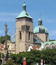
- The Marian column in the market square was probably created by Giovanni Battista Bulla in 1715. The figures of Saints Andrew, Florian, Johannes von Nepomuk and Wenceslaus are located on its base.
- The parish church of the Assumption of the Virgin Mary from the 13th century was destroyed in the Hussite Wars and was only rebuilt in 1633–1637 under Jan Rudolf Trčka von Lípa. The main altar with carvings dates from 1661. The dome was painted by Johann Jakob Stevens von Steinfels .
- The oldest bell in Bohemia is located in the church tower, which was not destroyed. It was cast around 1300.
- The Augustinian monastery with the monastery church of the Holy Family was built between 1678 and 1733.
Town twinning
Are sister cities of Havlíčkův Brod
-
 Brielle , the Netherlands, since 1985
 -
 Spišská Nová Ves , Slovakia, since 1995
 -
 Brixen (South Tyrol / Italy), since 2007 ( Karel Havlíček lived there in exile from 1851 to 1855 )
Personalities
- Johann Stamitz (1717–1757), founder of the early classical Mannheim school
- Antonín Kalina (1870–1922), politician
- Vilém Kurz (1872–1945), pianist and music teacher
- Robert Mahler (1882–1953), composer; Founder of the Mahler Orchestra in Valdivia, Chile
- Pavel Landovský (1936–2014), actor, playwright and director
- Jaroslav Holík (1942–2015), Czechoslovak national ice hockey player
- Josef Augusta (1946–2017), ice hockey player and coach
- Pavel Poc (* 1964), politician
- Martin Čech (1976–2007), ice hockey player
- Jarmila Machačová (* 1986), racing cyclist
literature
- Joachim Bahlcke , Winfried Eberhard, Miloslav Polívka (eds.): Handbook of historical places . Volume: Bohemia and Moravia (= Kröner's pocket edition . Volume 329). Kröner, Stuttgart 1998, ISBN 3-520-32901-8 , pp. 107-109.
- Anne Kotzan: Knaur's cultural guide in color Czech Republic, Slovak Republic. Droemer Knaur, Munich 1993, ISBN 3-426-26609-1 , pp. 84-86.
- Karl Hinterlechner: Geological conditions in the area of the Deutschbrod map sheet (Zone 7 / XIII). In: Yearbook of the Imperial Royal Geological Institute. Vol. 57, 1907, ZDB -ID 217948-9 , pp. 115-374 .
Web links
- Havlíčkův Brod (Czech)
- Bohemia 1915, history, 102 districts
- The crisis in the bohemian mining industry around 1400
Individual evidence
- ↑ Český statistický úřad - The population of the Czech municipalities as of January 1, 2019 (PDF; 7.4 MiB)
- ↑ http://www.pesek.wz.cz/okrouhlice/cesky/dejiny.htm
- ^ A b Antonín Profous: Místní jména v Čechách: Jejich vznik, původ, význam a změny. Vol. I-IV .; Prague
- ^ City website - Partnerská města , accessed on May 11, 2017


